| ルブア・ハーリー沙漠(الربع الخالي)内および周囲の露頭のほとんどが炭酸塩であるにもかかわらず、ルブア・ハーリー沙漠(الربع الخالي)の大部分では堆積物は主に珪質で、その最大90%が石英で、残りは主に長石です。ただし、ルブア・ハーリー沙漠(الربع الخالي)東部では、単結晶石英が約71〜76%、長石が14〜16%を占め、残りは炭酸塩、チャート、変成粒子で構成されています。 | In most of Rub’ al Khali (الربع الخالي), sediments are mainly siliceous, up to 90% quartz, and rest mainly feldspar, although almost all outcrops in and around Rub’ al Khali (الربع الخالي) are carbonate. In eastern Rub’ al Khali (الربع الخالي), monocrystalline quartz makes up about 71–76%, feldspar makes up 14–16%, and rest consists of carbonate, chert, and metamorphic grains. |
| 堆積物は淡黄色から赤みがかった黄色で、石英粒子の表面に酸化鉄が薄く付着しているため、東部でも赤く見えます。アラビア湾(الخليج العربي)から約100 km以内のルブア・ハーリー沙漠(الربع الخالي)北部と東部の砂丘はおおむね石灰質で、炭酸塩はドロマイトまたは方解石に対して二次的な量のままです。沙漠の最北東部でも堆積物は珪岩のままで、不思議なことに深い赤色をしています。 | Color of deposits is light yellow to reddish yellow, and surfaces of quartz particles are lightly coated with ferric oxide, so they appear red even in eastern Rub’ al Khali (الربع الخالي). Within about 100 km from Arabian Gulf (الخليج العربي), dunes in northern and eastern Rub’ al Khali (الربع الخالي) are largely calcareous, with carbonates remaining secondary to either dolomite or calcite. Even in northeastern Rub’ al Khali (الربع الخالي), sediments remain quartzite, and interestingly they show a deep red color. |
| もともと先カンブリア時代の主なアラビア楯状地(الدرع العربي)の結晶質岩石から大量の砂が侵食されました。侵食された砂の多くは、新第三紀のハドルク層(تكوين حضرك)とホフーフ層(تكوين الهفوف)、カンブリア紀〜オルドビス紀のサク層(تكوين ساق)とワジッド層(تكوين واجد)などの多くの砕屑層に取り込まれました。これらの地層が風化して侵食されたことで、大量の緩い砂が解放されました。 | Large amounts of sand were originally eroded from crystalline rocks of main Precambrian Arabian Shield (الدرع العربي). Much of this eroded sand is incorporated into many clastic layers, including Hadrukh Formation (تكوين حضرك) and Hofuf Formation (تكوين الهفوف) of Neogene, and Saq Formation (تكوين ساق) and Wajid Formation (تكوين واجد) of Cambro‑Ordovician. Large amounts of loose sand were released as these formations weathered and eroded. |
| 中新世と鮮新世の時代に、隆起したアラビア楯状地(الدرع العربي)からの排水が内部ホモクラインの中生代の断崖を突き破り、大量の石英質の砕屑性堆積物を運び込み、現在の中新世ハドルク層(تكوين حضرك)と鮮新世ホフーフ層(تكوين الهفوف)を形成しました。未分化の上部第三紀の砂と泥灰土であるこれらの砂質の新第三紀層は、後にルブア・ハーリー沙漠(الربع الخالي)にある大量の砂の供給源になりました。 | During Miocene and Pliocene, drainage from uplifted Arabian Shield (الدرع العربي) broke through Mesozoic cliffs of interior homocline and deposited large amounts of quartz detrital sediments, forming what are now Miocene Hadrukh Formation (تكوين حضرك) and Pliocene Hofuf Formation (تكوين الهفوف). As undifferentiated Upper Tertiary sand and marl, these sandy Neogene layers later became a major source of large amounts of sand in Rub’ al Khali (الربع الخالي). |
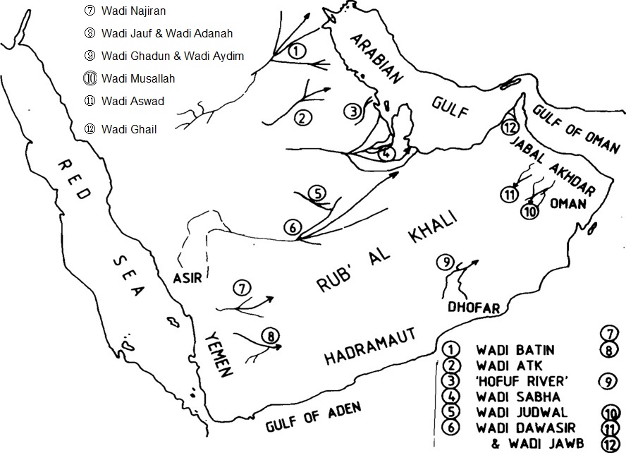
| 中新世と鮮新世の間は多湿で湿潤な気候が優勢で、鮮新世初期の第四紀には非常に大きな扇状地が形成されました。サラワート山脈(جبال السروات)の分水嶺に広い集水域を持つ涸れ谷ビーシャ(وادي بيشة)と涸れ谷タスリース(وادي تثليث)を支流としている涸れ谷ダワースィル(وادي الدواسر)は、その他の涸れ谷サフバー(وادي الصهباء)、涸れ谷ナジュラーン(وادي نجران)、涸れ谷ハブーナ(وادي حبونة)などの主要な涸れ谷と共に、礫岩と砂の堆積物をルブア・ハーリー沙漠(الربع الخالي)に運び込みました。これらの堆積物が、現在のルブア・ハーリー沙漠(الربع الخالي)の赤い砂の源になっています。 | A humid climate dominated between Miocene and Pliocene, and a very large alluvial fan formed in early Quaternary of Pliocene. Wadi ad‑Dawasir (وادي الدواسر), which has Wadi Bisha (وادي بيشة) and Wadi Tathlith (وادي تثليث) as its tributaries with wide catchment areas in watershed of Sarawat Mountains (جبال السروات), represents this system. Other major wadis such as Wadi as‑Sahba (وادي الصهباء), Wadi Najran (وادي نجران), and Wadi Habunah (وادي حبونة) also carried gravel and sand into Rub’ al Khali (الربع الخالي). These deposits became source of today’s red sand in Rub’ al Khali (الربع الخالي). |
| 降水量が多い時期には、ザグロス山脈(جبال زاغروس)やイラン高原(الهضبة الإيرانية)の他の高地が強く侵食され、堆積物はチグリス川(نهر دجلة)、カロン川(نهر كارون)、その他の河川によってアラビア湾(الخليج العربي)へ運ばれました。特にルブア・ハーリー沙漠(الربع الخالي)の北部および北東部の砂丘には、陸地化して乾燥していた時期のアラビア湾から、現在よりも強い風によって堆積物が運ばれてきました。 | During periods of high rainfall, Zagros Mountains (جبال زاغروس) and other highlands of Iranian Plateau (الهضبة الإيرانية) were heavily eroded, and sediments were carried to Arabian Gulf (الخليج العربي) by Tigris River, Karun River, and other rivers. In northern and northeastern Rub’ al Khali (الربع الخالي), sediments were transported by winds stronger than today from Arabian Gulf during times when it had been exposed land and extremely dry. |
| ザグロス山脈(جبال زاغروس)のさまざまな地層は、その分布範囲がルブア・ハーリー沙漠(الربع الخالي)の堆積物の主な発生源であることが、ほぼ確認されています。イラン南部に広く露出するアガジャリ層(تكوين آغاجاري)は、主に石英砂岩で構成されています。同様に、バフティヤーリー礫岩(تكوين بختياري)は石英砂を多く含む厚いマトリックスを持っていますが、炭酸塩はザグロス山脈では一般的です。 | Various formations of Zagros Mountains (جبال زاغروس) are now considered major sources of sediments in Rub’ al Khali (الربع الخالي). Agha Jari Formation (تكوين آغاجاري), widely exposed across southern Iran, is mainly composed of quartz sandstone. Bakhtiari Conglomerate (تكوين بختياري) also contains a thick matrix of quartz sand, while carbonates are common in Zagros Mountains. |
| アラブ首長国連邦北部の砂丘に含まれる炭酸塩物質の多くはザグロス山脈(جبال زاغروس)に由来し、シャマール風によってルブア・ハーリー沙漠(الربع الخالي)地域へ運ばれました。これらの堆積物は、アラビア湾(الخليج العربي)沿岸のジャーフーラ沙漠(صحراء الجافورة)や白い海岸砂丘を形成するとともに、ルブア・ハーリー沙漠(الربع الخالي)の堆積物増加にも寄与しています。 | Carbonate sediments in dunes of northern United Arab Emirates originate from Zagros Mountains (جبال زاغروس) and were transported by shamal winds to Rub’ al Khali (الربع الخالي). These sediments also form Jafurah Desert (صحراء الجافورة) and white coastal dunes along Arabian Gulf (الخليج العربي), and they further contribute to sediment accumulation in Rub’ al Khali (الربع الخالي). |
| 第3のルブア・ハーリー沙漠(الربع الخالي)への堆積物供給源としては、オマーンのハジャル山脈(جبال الحجر)があります。この山脈の高い山々から南東へ流れる多くの急な涸れ谷(ワーディー)が、東部と北東部に大量の沖積層と砂利を供給しており、この豊富な供給源によって、ウルーク・ムウタリダ(عروق المترادة)やガニーム・サンド(كثبان غانم)のような、高く大きな三日月形砂丘が形成されました。 | A third source of sediment to Rub’ al Khali (الربع الخالي) is Hajar Mountains (جبال الحجر) in Oman. Many steep wadis flowing southeast from this high mountain range supply large amounts of alluvium and gravel to eastern and northeastern Rub’ al Khali, and this abundant source produced large high crescent dunes such as Uruq Al Mutaridah (عروق المترادة) and Ghanim Sands (كثبان غانم). |