4 Heavy Rainfall and Post-Ice Age

目次
Contents
4.1 最後の地殻変動
4.1 Last Crustal Movement
| アラビア半島での最後の地殻変動は、300万年前の鮮新世中期(500万年から160万年前)に始まり、ザグロス(زاغروس)山脈を現在の標高まで押し上げ、半島の西東斜面をさらに増加させました。 | Last crustal movement at Arabian Peninsula began 3 million years ago in middle of Pliocene (5 to 1.6 million years ago), pushing Zagros (زاغروس) Mountains to their current elevation and further increasing west-east slope of Arabian Peninsula |
| アラビア湾が誕生し、アラビア半島東部では地層に油田の石油貯蔵構造となる「褶曲」と呼ばれるうねり状の曲がり角が作られました。 | Arabian Gulf was born, and in eastern part of this Peninsula, a swell-like bend called “fold”, which became oil storage structure of oil field, was created in stratum. |
4.2 多雨期と氷河と氷の時代
4.2 Pluvial Period and Glacier & Ice Period
| 同じく300万年から200万年前、アラビア半島では雨が多く降り、初期は非常に湿度が高かっただけでなく、気温も上昇しました。亜熱帯林がアラビア半島の大部分を覆い、動物相は中央アフリカのものと似ていました。 | During that period, 3 to 2 million years ago, it rained heavily on Arabian Peninsula, and not only was it very humid in early days, but temperatures also increased. Subtropical forests covered most of Arabian Peninsula, and its fauna was similar to that of Central Africa. |
| しかし、260万年前から地球規模の気候変動があり、アラビア半島はますます冷涼で乾燥し、長い氷河と氷の時代が始まりました。 | However, there had been global climate change since 2.6 million years ago, and Arabian Peninsula had become increasingly cool and dry, marking e beginning of a long glacier and ice period. |
| 陸地を覆っていた森林はまばらになり、サバンナと呼ばれる木と草の土地が景観となり、動物相の数も新しい環境に適応するために変化しました。 | Forests that covered land have become sparse, and land of trees and grass called Savanna had become a landscape, and number of Fauna had changed to adapt to new environment. |
4.3 三大水系
4.3 Three Major River Systems
| 3 つの古代大河川である涸れ谷ルマ(وادي الرمة) /涸れ谷バーティン(وادي الباطن)、涸れ谷サフバー(وادي السهباء)および涸れ谷ダワースィル(وادي الدواسر) は、アラビア半島のこの時代を象徴しています。 | Three Great Ancient Rivers (Wadi Rumah (وادي الرمة) / Wadi Batin (وادي الباطن), Wadi Sahba (وادي السهباء), Wadi Dawasir (وادي الدواسر) represented this period of Arabian Peninsula. |
| これら 3 つの古代河川は西側の山々を浸食し、アラビア半島を横切って東側のアラビア湾へと流れていました。 | Those three ancient rivers eroded mountains on west side and flowed across Arabian Peninsula toward Arabian Gulf on east side. |
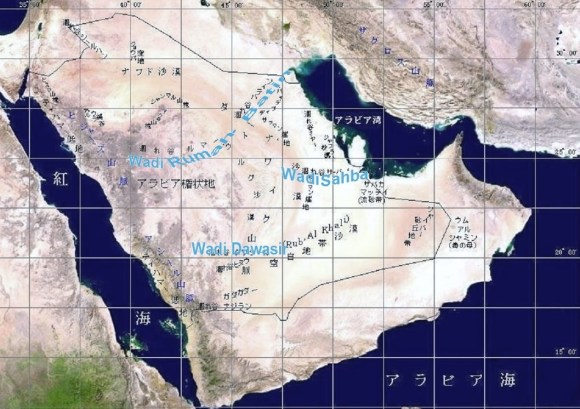
| アラビア半島の三大古代川 | Three Great Ancient Rivers |
| (Nasa衛星写真上へ高橋作図) | (Map drawn by Takahashi on NASA satellite image) |
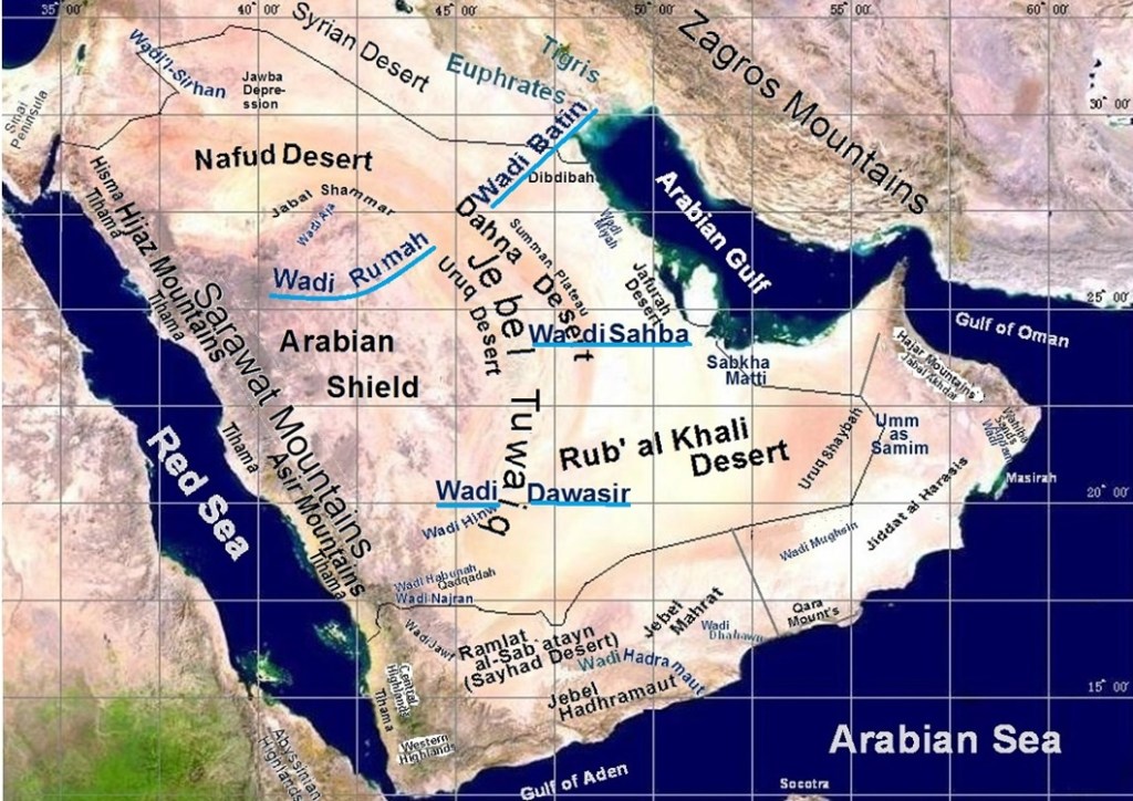
| アラビア半島の三大古代川 | Three Great Ancient Rivers |
| (Nasa衛星写真上へ高橋作図) | (Map drawn by Takahashi on NASA satellite image) |
4.4 涸れ谷ルマ・バーティン水系
4.4 Wadi Rumah / Batin River System
| 涸れ谷ルマは、アラビア半島中央部の排水路でした。この涸れ谷には、西側の溶岩帯から東側の中心部に流れるいくつかの支流があります。 | Wadi Rumah was a drainage channel in central part of Arabian Peninsula. This Wadi has several tributaries that flow from lava belts on west side to central part on east side. |
| これらの支流には、涸れ谷カハド(وادي قهد)、涸れ谷サーフーク(وادي ساحوق)、涸れ谷ジャリール(وادي جرير)などが挙げられます。西部の熔岩地帯には、フタイム熔岩地帯(حرة هتيم)、カイバル熔岩地帯(حرة خيبر)、ラハート熔岩地帯(حرة رهاط)があります。 | These tributaries include Wadi Qahad (وادي قهد), Wadi Sahuq (وادي ساحوق), and Wadi Jareer (وادي جرير). Western lava area includes Harrat Hutaym (حرة هتيم), Harrat Khaybar (حرة خيبر), and Harrat Rahat (حرة رهاط). |
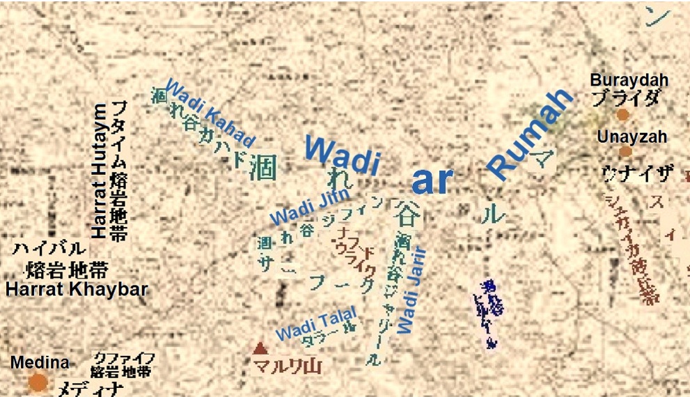
| 涸れ谷ルマの流域 | Watershed of Wadi ar Rumah |
| Google Map上への高橋追加作図 | Additions on Google Map drawn by Takahashi |
| 涸れ谷ルマの下流は、現在ダフナー沙漠(صحراء الدهناء)に覆われていますが、水は地下を流れて涸れ谷バーティンに流れているようです。涸れ谷バーティンは、クウェートに流れ、アラビア湾に直接注ぎ込んでいました。涸れ谷バーティンは河口で扇形の三角州を形成しました。 | Lower reaches of Wadi Rumah are now covered by Dahna Desert (صحراء الدهناء), but water seems to be underground and flowing to Wadi Batin. Wadi Batin flows to Kuwait, it had directly poured into Arabian Gulf. Wadi Batin formed a fan-shaped delta at its estuary. |
| 三角州は、現在ディブディバ(دبدبة)と呼ばれる広大な砂利平野で、カイスーマ(قيصومة)を頂点としてクウェートを囲むアラビア半島北東部の大部分を占めています。 | Delta is vast gravel plain now called Dibdibah (دبدبة), which occupies most of northeastern part of Arabian Peninsula with Qaysumah (قيصومة ) at top and surrounding Kuwait. |
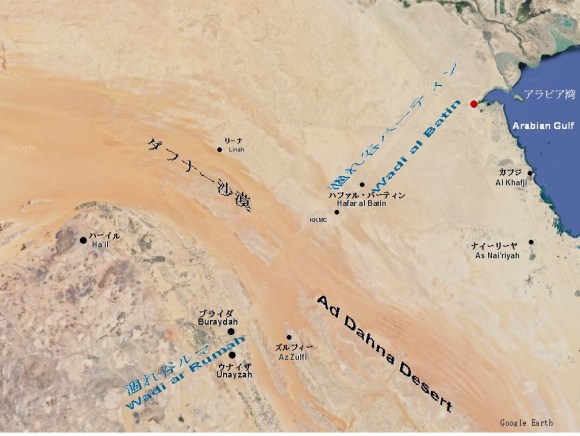
| 涸れ谷ルマ・バーティン | Wadi ar Rumah / Wadi al Batin |
| Google Map上への高橋追加作図 | Additions on Google Map drawn by Takahashi |
4.5 涸れ谷サフバー水系
4.5 Wadi Sahba River System
| 涸れ谷サフバーは中央アラビアの排水路を形成しました。その本流は、リヤード(رياض)の南、中央半島のやや東で主要な支流に合流します。主要な支流は、涸れ谷ニサーフ(وادي نساح)、涸れ谷ハウタ(وادي حوطة)、涸れ谷ビルク(وادي البرك)です。 | Wadi Sahba formed a drainage channel in Central Arabia. Its main stream joins its major tributaries, south of Riyadh (رياض), slightly east in Central Arabian Peninsula. Main tributaries are Wadi Nisah (وادي نساح), Wadi Hawtat (وادي حوطة) and Wadi Birk (وادي البرك). |
| それぞれトゥワイク山脈(جبال طويق)を流れ、その後、北から流れてくる涸れ谷ハニーファ(وادي حنيفة)に合流します。涸れ谷ハニーファは、ハルジュ(خرج)から東に流れ、ハラド(حرض)近くのスンマーン高原(الصمان)を通過し、カタール半島の付け根近くのアラビア湾に注ぎます。 | Each run respectively through Jebel Tuwaiq (جبال طويق). Then, it joins Wadi Hanifa (وادي حنيفة), which flows from north, near Kharj (خرج). It flowed east from Kharj, pass through Summan Plateau (الصمان) near Haradh (حرض) and pouring into Arabian Gulf near base of Qatar Peninsula. |
| この涸れ谷は、古代には南ナジュド(جنوب نجد)全体を排水する主要な川でもありました。 | This Wadi was also a major ancient river that drained entire Southern Najd (جنوب نجد) in that time. |
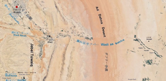
| 涸れ谷サフバー | Wadi Sahba |
| Google Map上への高橋追加作図 | Takahashi’s additions to Google Maps |
| 河口デルタの名残は、流砂地帯「サブハ・マッティー(سبخة مطي)」と薄い砂利の扇状地です。この扇状地は、ハラドから今日の海岸まで広がっています。 | Remnants of its estuary delta are quicksand belt “Sabkha Matti (سبخة مطي ” and a thin gravel alluvial fan. This alluvial fan extends from Haradh to today’s coast. |
| その長さは200km、弧の幅はウカイル(العقير)からカタールまで150kmでした。 | Its length was 200km and its arc width was a 150km from Uqayr (لعقير) to Qatar. |
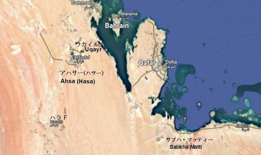
| 涸れ谷サフバーの河口部 | Estuary of Wadi Sahba |
| Google Map上への高橋追加作図 | Takahashi’s additions to Google Maps |
4.6 涸れ谷ダワースィル水系
4.6 Wadi Dawasir River System
| 涸れ谷ダワースィル(وادي الدواس ر)は、アシール山脈(جبال عسير)の東斜面からの流水を集め、スライル(السليل)近くでトゥワイク山脈(جبال طويق)を切り通していました。 | Wadi Dawasir (وادي الدواسر) collects running water from eastern slopes of Asir Mountains (جبال عسير) and swept through Jebel Tuwaiq (جبال طويق) near Sulayyil (السليل). |
| 同様に、その支流である涸れ谷ヒンウ(وادي الحنو)は、カルヤ・アル=ファーウ(قرية لفاو)遺跡近くのトゥワイク山脈を貫いていました。合流後、涸れ谷ダワースィルは東に流れ、アラビア楯状地から浸食された土、砂、瓦礫などでルブア・ハーリー沙漠(الربع الخالي) (空白地帯)の広い地域を埋め尽くしました。 | Similarly, its tributary, Wadi Hinw (وادي الحنو), pierced Jebel Tuwaiq near Qaryat al Faw (قرية الفاو) ruins. After merging, Wadi Dawasir flowed eastward and filled a large area of Rub’ al Khali desert (الربع الخالي), with soil, sand, rubble etc. eroded from Arabian Shield. |

| 涸れ谷ダワースィル地方とその周辺 | Wadi Dawasir and its surroundings |
| Google Map上への高橋追加作図 | Takahashi’s additions to Google Maps |
| 現在、涸れ谷ダワースィルの下流は、厚い漂砂のため、はっきりしません。しかし、かつては、海に覆われていたルブア・ハーリー沙漠に低地のデルタを形成し、ルブア・ハーリー沙漠の南東部にある巨大な湖に注ぎ込んでいました。 | Nowadays, lower reaches of Wadi Dawasir are not clear due to thick sand drift. However, it formed a low-lying delta in Rub’ al Khali desert, which had once been covered by sea, and poured into a huge lake in Southeastern Rub’ al Khali desert. |
| 現在、湖の遺跡は流砂地帯(サブカ(سبخة))となっています。そして、この地域は、特に車が立ち往生しやすいため、通過するのが難しい場所であり、アラビア語で「すべての毒の母」を意味する「ウンム・アル=サミーン(أم السميم)」と呼ばれています。 | Currently, ruins of lake are a quicksand zone (Sabkha (سبخة). And as this area is especially easily to be gotten car stuck, it is a difficult place to pass, called “Umm al Samin (أم السميم)” which means ” mother of whole poisons” in Arabic. |
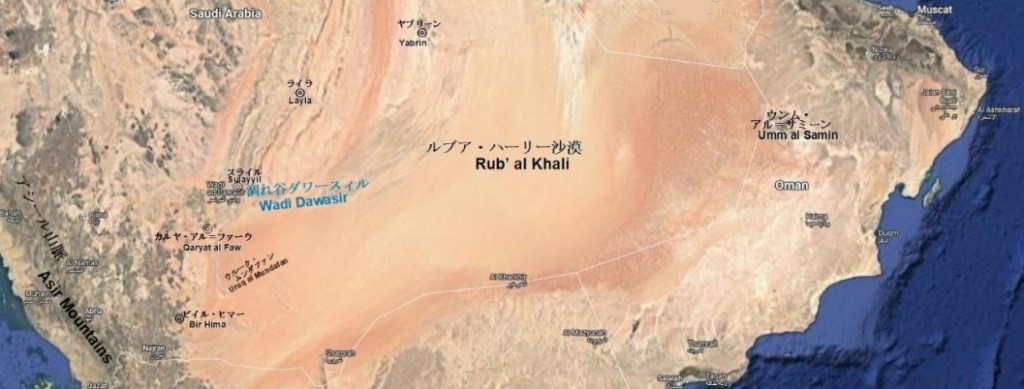
| ダワースィル古代川の流域 | Ancient Flow Traces of Wadi Dawasir |
| Google Map上への高橋追加作図 | Takahashi’s additions to Google Maps |
4.7最後の極地氷河活動期
4.7 Last Activity of Polar Glaciers
| 260万年前からの世界規模の気候変動は、厚い氷層を持つ極地の氷河の最後の活動が始まることを意味しました。地球表面の水資源の多くは広大な氷層に閉じ込められ、海面は大幅に低下しました。 | Global climate change from 2.6 million years ago meant that last activity of polar glaciers with thick ice layers would begin. Many of water resources on surface of Earth were confined to vast ice layer, and sea level declined significantly. |
| 150万年前の更新世初期には、海面は現在の高さより75m高まっていました。更新世の海面は徐々に低下し、氷河が最盛期だった2万年前には、海面は現在よりも100m低くなっていました。 | 1.5 million years ago during early Pleistocene, sea level was 75 meters above current height. Pleistocene sea level gradually declined, and 20,000 years ago, when glaciers were at their peak, sea level was 100 meters lower than it is today. |
| アラビア湾は、ホルムズ海峡(مضيق هرمز)まで干上がり、オマーン湾(خليج عمان)に直接流れ込むチグリス川(نهر دجلة)とユーフラテス(الفرات)の流れを除いて、イランからドバイ(دبي)をまで歩ける平野でした。 | Arabian Gulf was dried up to Strait of Hormuz (مضيق هرمز) and was a walkable plain from Iran to Dubai (دبي) except for river stream of Tigris River (نهر دجلة) and Euphrates (نهر الفرات), which flowed directly into Gulf of Oman (خليج عمان). |
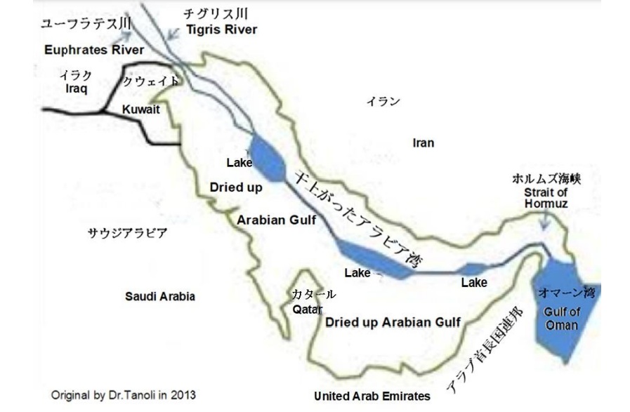
| 干上がったアラビア湾 | Dried up Arabian Gulf |
| 「約14,000年前のアラビア湾地図」への高橋による追加作図 | Additions to “Arabian Gulf Reconstruction circa 14,000 Years B.P.” by Takahashi |
4.8 氷期終わりに近くの湿潤期
4.8 Moist Period near End of Ice Age
| 氷期が終わりに近づいた約3万5000年前に始まり、1万8000年前まで続いた湿潤時代は、陸地の様相を一変させました。 | Moist period, which began about 35,000 years ago, when ice age was nearing its end, and lasted until 18,000 years ago, completely changed appearance of land. |
| しかし、3つの古代河川は長い間砂丘やその他の脆弱な堆積物によって堰き止められていたため、豊富な川の水量でさえも川を元の状態に戻すには不十分でした。 | However, three ancient rivers had been blocked by dunes and other fragile sediments for so long that even abundant river flows were not enough to restore those rivers to their original states. |
| ヤブリーン(يبرين)、ライラ(ليلى)、アハサー(أحساء)(ハサー(حسا))の広大な湖、そしてさらに南にあるウルーク・ムンダファン(عروق المندفن)とラムラト・アル=サバタイン湖(رملة السبعتين)は、風景の中に永久に残るものとなりました。 | Vast lakes of Yabrin (يبرين), Layla(ليلى), Ahsa (أحساء) (Hasa (حسا)) and also those of Uruq al Mundafan (عروق المندفن) and Ramlat al-Sab’atayn (رملة السبعتين) in further south had become permanent features in landscape. |
| 森林と草原が地面を覆い、バッファローやレイヨウなどの草食動物が戻り、カバが湖の水生植物を食べていました。今日残っている骨は、ゾウが地面を歩き回っていたことを示しています。それら様子は、ビイル・ヒマー(بئر حما)等、多くの場所で岩絵に残されています。 | Forests and grasslands covered ground, herbivores such as buffalo and antelope returned and hippos were eating aquatic plants in lakes. Remained bones of today show that elephants were roaming ground. These scenes are depicted in rock arts in many places, such as Bir Hima (بئر حما). |
| 約17,000年前以来、これらの湖は枯渇したか、その表面が大幅に縮小しました。中央アラビアを歩き回っていたレイヨウ、バッファロー、カバなどの多くの化石は、乾燥したシルト湖の底に埋まっています | Since about 17,000 years ago, these lakes were depleted or their surface had shrunk significantly. Many fossils such as antelope, buffalo and hippopotamus that roamed Central Arabia are buried in bottom of dry silt lakes. |
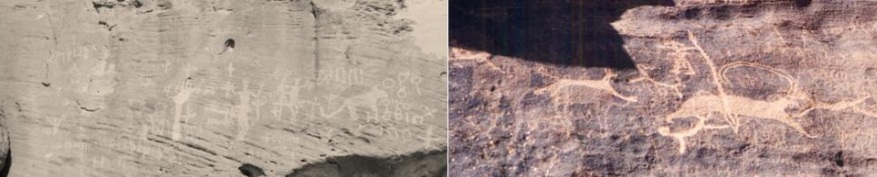
| 古代の岩絵(狩の風景)撮影 高橋 | Ancient rock arts (hunting scenes) Photography by Takahashi |
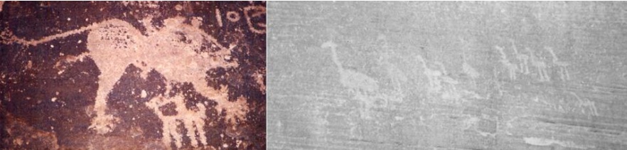
| 古代の岩絵(ライオンと一群れの駝鳥) 撮影 高橋 | Ancient rock arts (a lion and a flock of ostrich) Photography by Takahashi |
4.9 乾燥期と砂丘形成
4.9 Dry Period and Forming Dune Areas
| 3,000 年間の乾燥期に、土壌は、乾燥して塵とな り、卓越風向に沿って移動し、15,000 年前までに アラビア半島の 3 分の 1 を覆う砂丘地帯を形成し ました。安定した表土がなくなると、すぐに土は乾 燥して塵となり、風に運ばれて砂丘を形成します。 | During 3,000-year dry period, soil dried, became dust and moved along predominant wind direction, forming a dune area covering one third of Arabian Peninsula by 15,000 years ago. Once stable topsoil is gone, immediately soil dries and becomes dust and is carried by wind to develop dunes. |
| この時期にグレート・ナフード沙漠(الكبير النفود)、アド=ダフナー沙漠(الدهناء)、ルブア・ハーリー(الربع الخالي)沙漠等の砂丘が形成され、現在まで続いています。動物への影響は非常に深刻で、動物は、永 久に水が溜まる窪地に追いやられました。この間、 赤い砂は、北のグレート・ナフード沙漠からアド= ダフナー沙漠を通って南のルブア・ハーリー沙漠まで移動しています。 | Great Nafud (الكبير النفود), Ad Dahna (الدهناء) and Rub’al Khali (الخالي الربع) desert dunes were formed during this period and continue to this day. Effects on animals were so severe that they were driven into depressions with permanent water. During this time, red sand is moving from Great Nafud in north Rub’ al Khali desert in south through Ad Dahna. |
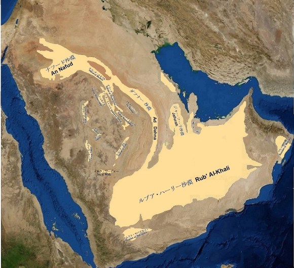
| アラビア半島の砂丘地帯 | Sand dunes on Arabian Peninsula |
| Nasa衛星写真上へ高橋作図 | Additions by Takahashi on NASA Satellite Image |
4.10基本的な乾燥化の中での湿潤気候
4.10 Humid Climates amidst Arid Trend
| 9,000 年前に雨が戻ったということは、人類がこの 地に再び定住するための良好な環境が戻ったことを 意味しました。 | Return of rainfall 9,000 years ago meant that good environmental conditions would return for humankind to re-establish itself in land. |
| この時代における湿潤気候の復活 は、アラビア半島の南半分で顕著でした。オマーン のドファール(ظفار)地方にのみ雨をもたらすモンス ーンが北上し、ルブア・ハーリー沙漠全体に季節的 に雨を降らせました。 | Revival of humid climate of this period was remarkable in southern half of Arabian Peninsula. Monsoon, which only bring rain to Dhofar (ظفار) in Oman, moved north and made rain seasonally throughout Rub’ al Khali desert. |
| 永久草原が戻り、砂丘は表土 で覆われて安定し、湖の残骸には水が再び満たされ ました。湿潤気候は 4,500 年前、紀元前 1 千年紀 初期と紀元前 1 千年紀初期に再び現れましたが、 半島は、基本的にかなり乾燥化が進みました。 | Permanent grasslands returned, dunes were covered with topsoil and stabilized, and lake remains were refilled with water. Humid climates reappeared 4,500 years ago and in early 1st millennium BC and early 1st millennium BC, but Arabian Peninsula basically has progressed much drier. |
| 砂丘 の景観は乾燥するにつれて形成され、そしてその表面は過去数世紀にわたって移動してきた極度に乾燥 した砂で覆われています。 | Landscape of dunes has been created as it dries. And its surface is covered with extremely dry sand that has moved over last few centuries. |
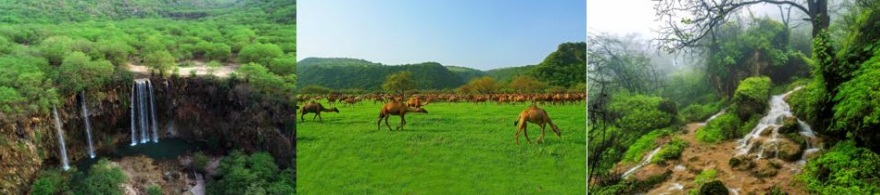
| サムハン山(جبل سمحان)と涸れ谷ダルバート (وادي دربات) | Samhan Mountain (جبل سمحان) and Wadi Darbat (وادي دربات) |

