
Surface Layers forming Basis of Terrain


Birth of Arabian Shield
(アラビア楯状地)


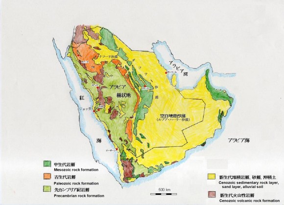
「アラビア半島の地形は、それぞれ景観に特徴のある火成岩系の花崗岩地帯と熔岩地帯、堆積岩系の砂岩地帯と石灰岩地帯および風成された砂丘地帯の5つの地帯に分けられる」と筆者は考えていいます。なお、変成岩は火成岩や堆積岩の一部として扱っい、地形用語としての「アラビア楯状地」は、その地上に露出している中央部および西部を指しています。
The terrain of the Arabian Peninsula is separated to 5 characteristic zones, which are the Granite Zone, the Lava Zone (Harrat), the Sandstone Zone, the Limestone Zone and the Sand Dune Zone. The Granite Zone and the Lava Zone (Harrat) are derived from the Igneous Rock. The Sandstone Zone and the Limestone Zone are derived from the Sedimentary Rock. The Sand Dune Zone is formed by the action of the erosion and the aeolian process. The Metamorphic rocks are treated here as the part of the Igneous Rock and/or the Sedimentary Rock and also the topographical term “the Arabian Shield” refers to the central and western parts exposed above the ground.
花崗岩地帯はアラビア楯状地の主要部を成し、緩やかに起伏していますが、場所によってハーイルのアジャー山塊の様に赤黒い大地が筋肉状の盛り上がりを見せています。花崗岩の山は、滑らかな山肌を残している赤黒部分、角が丸みを帯びた四角形に割れた暗い大石部分および更に小さな四角張った小石に割れて黒ずんだ黄土色に見える部分に、ほぼ3等分されます。
The Granite Zone forms the main part of the Arabian Shield and is gently undulating, but in some places the red-black the monolithic rock shows a ridge like muscular, such as the Jibal Aja in Ha’il. The granite Zone is roughly divided into three equal parts: the red-black part that leaves the monolithic rock with a smooth surface, the dark part formed of the square big stones with rounded corners, and the dark ocher part formed of the squared pebbles.
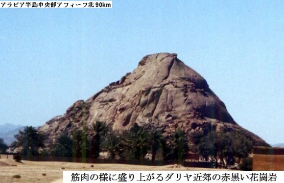
Red-black granite rising like muscles near Dariyah, 200km southwest of Qasim.
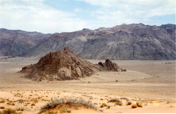
Granite rocky mountain near Hufail village, 50km west of Hayil
熔岩地帯(ハッラ)は、サラワート山脈に沿って、北部はヨルダンから続くハッラ(ラジル)熔岩地帯、中央部はマディーナ北のハイバル熔岩地帯とマディーナから南へと延びるラハート熔岩地帯、南部はバーハ北のビクーム熔岩地帯およびアブハー西の海岸に沿ったビルク熔岩地帯等、大小の熔岩地帯が発達しています。最大の熔岩地帯はハッラ(ラジル)熔岩地帯で、シリアからヨルダンを抜けて北部サウジアラビアまで広がる大規模なシャマー熔岩地帯の南の3分の1であり、北西から南東に長さ270km、幅75kmで広がっています。熔岩地帯は火山岩、熔岩、火山灰で被われており、火山がこの地域の至る所に散らばっていますが、噴火している火山は見られません。ハーイル南東にあるターバ火口の割れ目等一般に知られているような火山活動は、極めて限られていますが、2009年5月にヤンブー北のシャカ熔岩地帯で震度5.6の地震があり、アイス村の住人が暫く避難していた事もありました。これらの火山は高くも大きくもありませんが、ターイフの北東254kmにあるワアバ火口等は周囲が11キロに及びます。ワアバ火口はその底に白いリン酸ナトリウム等が堆積しているのが特徴的です。熔岩は粘性が低い為に非常に長い距離を流れ、この薄い熔岩膜には土壌の水分蒸発や温度上昇を抑えるマルチ効果があるので、熔岩地帯では多くの植生が育っています。
The Lava Zone (Harrat) runs along the Sarawat Mountains from Jordan to the north to Yemen to the south. Large and small the lava zones (the lava plain) are developing. The main ones are;
In the north, the Harrah (the Harrat Al Rajil),
In the center, the Harrat Khaybar (north of Medina) and the Harrat Rahat (extending south from Madinah),
In the south, the Harrat al Buqum (north of Bahah) and the Harrat al Birk (west coast of Abha).
The largest lava zone is the Harrah (the Harrat Al Rajil), that is 75km wide with 270 km long from northwest to southeast. The Harrah (the Harrat Al Rajil) is one-third southern part of the large the Harrat Ash Shamah, which stretches from Syria through Jordan to northern Saudi Arabia.
The lava zone is covered with the volcanic rock, the lava, the volcanic ash, etc., and the volcanoes are scattered throughout the area, but the erupting volcanoes are not seen. It is generally known as the crevice of the eruptive crater at Tabah in the southeastern part of Ha’il. However, such volcanic activity is relatively limited. In May 2009, there was an earthquake with a seismic intensity of 5.6 at the Harrat Al-Shaqa north of Yanbu, and residents of Ais village had been evacuated for a while. These volcanoes are neither tall nor large, but the Wahbah Crater, 254 km northeast of Taif, is an exception. Its circumference extends for 11 kilometers. The Wahbah Crater is characterized by the accumulation of the white trisodium phosphate on its bottom. The lava here flows a very long distance due to its low viscosity. Many vegetation grows in the lava zone because this thin lava membrane has the effects of the Mulching that suppress soil evaporation and temperature rise.
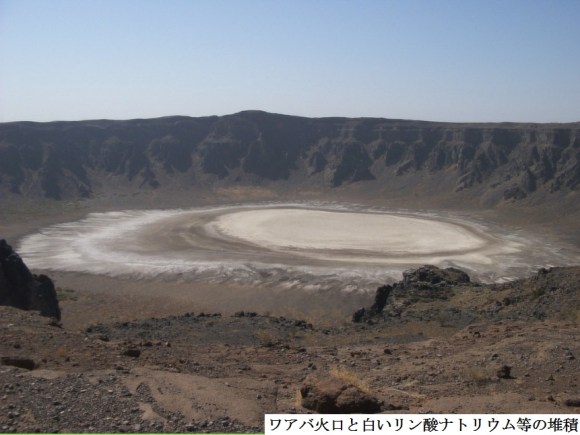
キシュブ熔岩地帯(Harrat Kishb)の西端にあります。
The Wahbah crater is located at the western end of the Harrat Kishb, which has many crater hills around 250 km northeast of Taif.
This crater is covered with white sodium phosphate precipitated.

A small lava area (Harrat) centered around 35km east-northeast of Jizan.
砂岩地帯では厚い山並みが発達しています。砂岩は時として空想的な形の岩を作り出し、多くの場所で絵画的な風景を作っています。冬のハーイル周辺のフッタ、ジュッバ、バカア等では雨さえ降れば、花崗岩の丘や砂岩の丘に囲まれた窪地に多くの小さな湖が現れ、その周囲は花や木々の緑が色づき、美しい牧草地になります。タブーク州ウラー渓谷では青い空を背景に麓の緑に縁取られ、黒い熔岩を被った赤い砂岩の垂直に近い長い絶壁が回廊の様に続いています。アシール州ビーシャでは切り立った丘の間の小さな渓谷を進むとそこここにナツメ椰子の畑を持つ、青空に映える静かで美しい佇まいの小さな村々が見られます。アブハーの南にあるハバラの切り立った断崖は、今ではケーブルカーが備えられていますが、「昔はバニー・マーリク族が崖下に隠れ住み、下帯だけの男達だけが縄を使って上り下りしていた」と云います。この赤い砂岩はアブハーのスーダ山等、サラワート山脈の頂上部も被っています。
Imposing mountains are developing in the Sandstone Zone. Red sandstone sometimes creates fantasy-shaped rocks, creating pictorial landscapes in many places. In winter around Ha’il, Khottah, Jubbah, Baq’a, etc., if it rains, many small lakes will appear in the depressions surrounded by granite hills and sandstone hills, and the surrounding area will be green with flowers and trees. Colors and becomes a beautiful meadow. In the `Ula Valley of the Tabuk Province, a long, near-vertical cliff of red sandstone covered with black lava continues like a corridor, bordered by green at the foot of the mountain against a blue sky. In Bisha, in the ‘Asir Province, a small village can be seen with a quiet and beautiful appearance against the blue sky, with fields of the date palm (Phoenix Dactylifera), going through a small valley between steep red sandstone hills. The overhanging red sandstone cliffs of Habalah, south of Abha, are now equipped with cable cars, but in the old days, the Bani Maleek hid under the cliffs, and only men in the lower belt climbed up and down with ropes. Red sandstone also covers the summits of the Sarawat Mountains, including the Soudah Mountains in Abha.

Hablah Cliffs 40km west-southwest of Abha
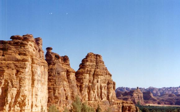
Steep red sandstone cliffs on either side of the Al Ula Valley, 380 km north of Madinah
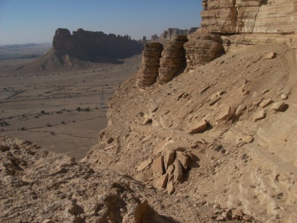
石灰岩地帯は半島の北部や東部を被い、飽きるほど果てしない広がりに特徴があります。内部は鍾乳洞が発達して大きな地下空間があります。しかし、地表部分は一般的に単調と云えるほど平な大地になっています。スンマーン台地やトゥワイク山脈の様な石灰岩の絶壁は、砂岩の絶壁より多少は丸みを持ちますが、西部劇にでも登場するような平頂山も形成します。その様な例はリヤードの近郊にも「世界の果て」、「ファイサル尖塔」、「第一駱駝の切り通し(キャメルパス)」等と名づけられている景観があります。
The Limestone Zone covers the northern and eastern parts of the peninsula and is characterized by an endless expanse. Inside, the karst caves have developed like the mazes and have a large underground space, but the surface of the earth is generally flat. Escarpments such as the Summan Plateau, the Jebel Tuwaiq etc. are somewhat rounder than sandstone cliffs, but also form the butte (an isolated hill with steep sides and a small flat top), as they appear in a Western movie. In the suburbs of Riyadh, there are landscapes named “the Edge of The World”, “the Faisal Pinnacle”, “the Camel Pass No. 1” and so on.

のリヤード西北西50km付近の断崖の一部
Part of the Tuwaiq Mountains (Jebel Tuwaiq) near 50km
West-northwest of Riyadh, known as the “End of the World”
リヤード西40km付近のトゥワイク山脈の一部
Part of the Tuwaiq Mountains near 40km west of Riyadh, called the First Camel Pass, a difficult part of the ancient Mecca Highway.

聳えるファイサル尖塔
The Faisal Pinnacle towering under the cliff, called Camel Pass,
at the west of Riyadh in the Tuwaiq Mountains.

The Pinnacle in the Hidden Valley of t the Wadi Nisah.
石灰岩地帯のもう一つの特徴は泉、緑地、湖等が多い事ですが、円形農場灌漑のために地下水のポンプによる汲み上げで水位が下り、今ではその多くが見られなくなってしまいました。一昔前まで、リヤード南東35kmにあるアイン・ヒート(ダフル・ヒート)やハルジュ泉の立て穴等もその入り口まで豊富な水がありましたが、今では水位が80m以上も下がってしまっています。カナート(地下水道)利用と美しい湖水で有名だったリヤード南方約300キロのライラも大小の湖が完全に干上がり、湖の化石になってしまっています。カナートは、ライラ、ドゥーマ・ジャンダル、タイマー、ハサーなどでの最も重要な灌漑方法の一つでしたが、地下水汲み上げで水位が下がり、完全に廃れてしまっています。ナツメヤシの水盤灌漑の浅い池では稲作が行われていた程、地下水の湧出量が豊富だった東部のカティーフやハサーでさえも海岸からの海水浸入に悩まされています。地上とは対照的に、地下での複雑な構造の鍾乳洞の発達が今日では多くの洞窟探検家を魅了しています。
Another feature of the Limestone Zone is that there are many springs, green areas, lakes, etc., but many of them are no longer seen because the water level was lowered by pumping groundwater for irrigation of the Center Pivot. In the decades ago, there was plenty of water up to the entrance of the Ain Hit (the Dahl Hit) located 35km southeast of Riyadh and also Ayun Al Seihs (the “eyes”) in Kharj. However now their water level has dropped by more than 80m. As to Layla, about 300 kilometers south of Riyadh, it was famous for its use of the Qanat (underground sewer) and the beautiful lake water. However, the large and small lakes have completely dried up and turned into the fossil lakes. The Qanat was one of the most important irrigation methods in Layla, Dumat al-Jundal, Tayma, Hasa (Ahsa), etc., but it has been completely abolished due to the drop in the underground water level due to the pumping of groundwater. Even Qatif and Hasa (Ahsa), where the amount of the groundwater discharged was so abundant that rice was cultivated in the shallow irrigation ponds for the date palms, have suffered from the seawater infiltration from the coast. In contrast to the above ground, the development of the complex limestone underground caves attracts many of the cave explorers today.
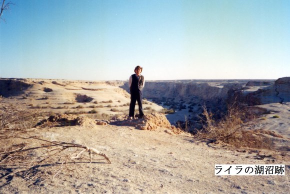
Lake ruins on the limestone plateau east of Layla, 260 km south of Riyadh

のジュバイル崖地下にある地底湖で知られる鍾乳洞
Ain Hit (Dahl Hit) known as an underground lake, beneath the Jubayl cliff,
35 km southeast of Riyadh and 45 km northwest of Kharj
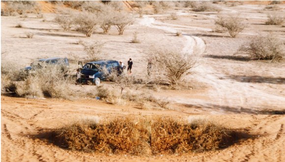
砂丘地帯はアラビア半島の特徴の一つで、広がったシート状や帯状の移動する砂がこの半島の3分の1強を被っています。7つの主要な砂丘地帯があり、その中のルブア・ハーリー沙漠は、砂が55万平方キロを被っている世界最大の砂沙漠です。北の偉大なナフード沙漠も大きく6万平方キロあります。この二つの間に横たわっているのがダフナー沙漠で、1,000キロに及ぶ東へ少し膨らんだ大きな弧型をして二つの砂の海を結んで北から南へと川の様に砂を運んでいます。ウルーク沙漠はシュカイカ砂丘帯、スワイラート砂丘帯、スィッル砂丘帯、クナイフィザ砂丘帯、ダヒー砂丘帯等の総称で、砂丘の細い帯が断続的に所々で重複しながらカスィームの直ぐ南からトゥワイク山脈の西の縁をダフナー沙漠と平行してワーディー・ダワースィルまで並んでいます。唯一、白いジャーフーラ沙漠はホフーフと南のルブア・ハーリー沙漠の間に横たわる移動する砂丘の塊です。ラムラト・サバタアインはイエメンのルブア・ハーリー沙漠外縁部で2.6万平方キロを被い、サイハド沙漠を包括しています。ワヒバ沙漠はオマーン東部の1.25万平方キロを被い、南縁はアラビア海に接している。その他、至る所で小さな砂沙漠が紅海岸のティハーマから岩だらけの涸れ谷の多いナジュドを抜け、アラビア湾岸まで陸地の多くの部分を横切ってつぎはぎの様に散らばっています。冬の雨は砂丘に貯えられ、その間の凹地に湧き出してジルフィー西の泉池、リヤード西のカララ湖(クルカーラ湖)、リヤード北のラウダ・フライム、ハーイル周辺の小さな湖群等のオアシスを作り出しています。又、砂丘の凹地には砂丘に貯えられた水の湧き出す多くの井戸があります。
The Sand Dune Zone, one of the characteristics of the Arabian Peninsula, the spreading sheet-like and strip-shaped moving sand covers more than one-third of the Peninsula. There are seven major the Sand Dune Zones, of which the Rub’al Khali Desert is the largest sand dune zone in the world with 550,000 square kilometers. The Great Nafud Desert in the north is also large, with 60,000 square kilometers. Lying between the two is the Dahna Desert, which carries sand from north to south like a sand river, connecting two seas of sand in a large arc that bulges eastward for 1,000 kilometers. The Uruq Desert is a general term for the Nafud Ash uqyyiqah, the Nafud al-Thuwayrat, the Nafud as Sirr, the Nafud Qunayfidhah, the Nafud al-Dahi, etc. and runs from just south of Qasim to Wadi al Dawasir. The Dahna Desert lines continuously to the east of the Jebel Tuwaiq, while the Uruq Desert lines intermittently to the west of Jebel Tuwaiq with narrow bands of dunes. The only white desert, the Jafurah Desert, is a mass of moving dunes that lies between Hasa (Ahsa) (Hofuf) and the Rub’al Khali Desert in the south. The Ramlat al-Sab’atayn covers 26,000 square kilometers at the outer edge of the Rub’al Khali Desert in Yemen and covers the Sayhad Desert. The Sharqiya Sands cover 15,000 square kilometers east of Oman and border the Arabian Sea on the southern edge. Elsewhere, small sand dune deserts are scattered across many parts of the Peninsula, from Tihama on the Red Sea Coast through the rocky Najd to the Arabian Gulf. Winter rains are stored in the dunes and spring up into the depressions between them, creating oasis such as west of Zilfi, the Lake Qurqarah southwest of Riyadh, Rawdhat Khuraym northeast of Riyadh, and small lakes around Ha’il. In addition, there are many wells in the depressions of the dunes where the water stored in the dunes springs out.

A luxurious villa with farmland and orchards between the dunes near Riyadh.

Shiqat al Kharitah, 180 km east of Najran and 120 km west of Sharourah Air Force Base, one of the dunes in the Rub’al Khali desert.
The Lake Qurqarah in the Nafud Qunayfidhah, southwest of Riyadh.

The Rawdhat Khuraym northeast of Riyadh
