
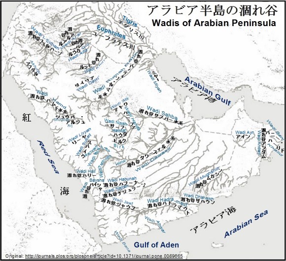
Wadis of Arabian Peninsula


Birth of Arabian Shield
(アラビア楯状地)
前書き
Preface
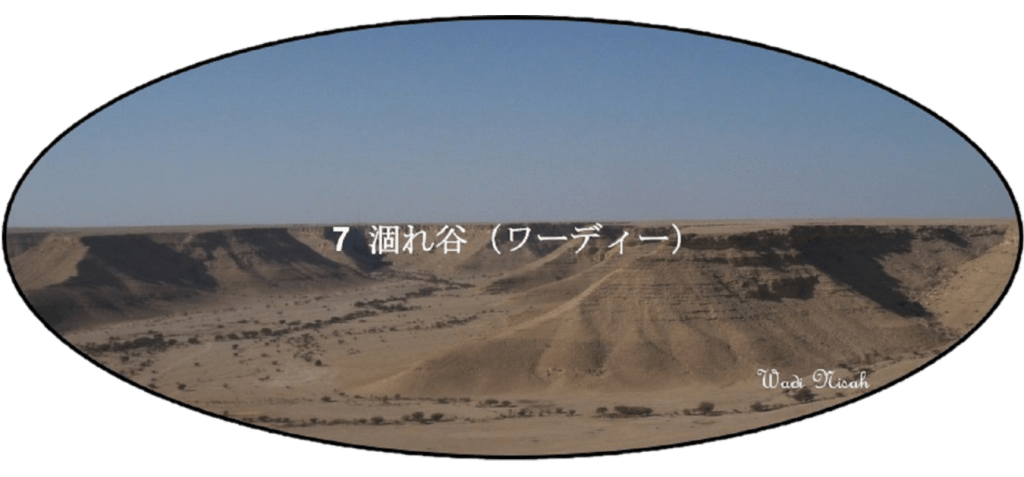
山脈、平原や砂丘地帯と共にアラビア半島の地形を形作る涸れ谷(ワーディー)には大小さまざまあります。現在はそのほとんどが砂や沈泥でおおわれて埋まっています。かつては海や太古の湖まで流れ出ていた水系の一部であるものが多いのですが、枯渇した太古の湖の一部であるものも少なくありません。
涸れ谷(ワーディー)と云う呼び名は、一時的に水の流れのある場所であれば、どこにでもに使われています。殆ど平らな沙漠でも涸れ谷と呼ばれて不思議に思いますが、一旦、雨が降るとそんな平らな場所であっても広い範囲から大量の水が集まり河を作り出します。
谷状に成った涸れ谷は、両側の山の高さの割に谷の幅がやたらに広く感じます。これは平らな土地で集水域が大きく、山の高さの割に流水量が多いのに加え、風で運ばれた砂等の堆積で場合によっては数十メートルから百メートルを超える程、埋められている為と、考えられます。
涸れ谷の始まりは降雨等の水源さえあれば沙漠の何処でも良いのですが、涸れ谷の終焉には
アラビア湾に注ぐ涸れ谷 (Wadis flowing into the Arabian Gulf)、
紅海に注ぐ涸れ谷 (Wadis flowing into the Red Sea) 、
アラビア海およびアデン湾に注ぐ涸れ谷 (Wadis flowing into the Arabian Sea and the Gulf of Aden) および内陸の涸れ谷 (Inland Wadis) 等、
幾つかの型があります。いずれにせよ、文末にご紹介する 旅客機の中から見た中東の河 (Middle Eastern rivers seen from an airplane) に共通する特徴を持っています。
There are various sizes of wadis. They form the terrain of the Arabian Peninsula together with mountains, plains, sand dunes, etc. however most of them are now covered with sand and/or silt. Many of wadis used to be part of the water system that flowed to the sea and/or the ancient lakes. Some of the current wadis are a part of the depleted ancient lakes.
The name wadi is used to be all places wherever there is a temporary water stream. It feels strange that even an almost flat desert is called a wadi. Once it rains, water gathers from a wide range to create a river even in such a flat place.
The valley-shaped wadis seems that the width of the valley is rather wide for the height of the mountains on both sides. This seems two(2) reasons; a wide-range catchment, and a big mount of running water. In addition to them, the valley is filled with the sand accumulation carried by the wind. In some cases, its depth is several tens of meters to more than a hundred meters.
A beginning of a wadi can be anywhere in the desert as long as there is a water source such as rainfall, but an end of a wadi is classified to the several types;
Wadis flowing into the Arabian Gulf 、
Wadis flowing into the Red Sea,
Wadis flowing into the Arabian Sea and the Gulf of Aden and
Inland Wadis , etc.
アラビア半島の涸れ谷一覧 List of wadi valleys on the Arabian Peninsula
| アラビア湾に注ぐ涸れ谷 | لوديان تتدفق إلى الخليج العربي | Wadis flowing into the Arabian Gulf |
| 涸れ谷バーティン・ルマ水系 | وادي الرمة / وادي الباطن | Wadi ar Rumah / al Batin system |
| 涸れ谷サフバー水系 | وادي السهباء | Wadi as Sahba system |
| 涸れ谷ダワースィル水系 | وادي الدواسر | Wadi al Dawasir system |
| 涸れ谷ミヤー水系 | وادي المياه | Wadi al Miyah system |
| 紅海に注ぐ涸れ谷 | تصب الوديان في البحر الأحمر | Wadis flowing into the Red Sea |
| 涸れ谷ハムド水系 | وادي حمض | Wadi Hamd sysytem |
| 涸れ谷ハリー水系 | وادي حلي | Wadi Hali system |
| 涸れ谷バイシャ水系 | وادي بيشة | Wadi Baysha system |
| その他 | الأودية الأخرى | The other systems |
| アラビア海およびアデン湾に注ぐ 涸れ谷 | الأودية التي تصب في بحر العرب وخليج عدن | Wadis flowing into the Arabian Sea and the Gulf of Aden |
| 涸れ谷バニー・カーリド | وادي بني خالد | Wadi Bani Khalid |
| 涸れ谷アンダーム | وادي أندام | Wadi Andam |
| 涸れ谷ダウアン(涸れ谷ザハウン) | وادي دوعن | Wadi Dawan (Wadi Dhahawn) |
| 涸れ谷ハドラマウト | حضرموت وادي | Wadi Hadramaut system |
| 涸れ谷アフワール | احـور وادي | Wadi Ahwar |
| 涸れ谷バナー | وادي بنا | Wadi Bana |
| 内陸の涸れ谷 | الوديان الداخلية | Inland Wadis |
| 涸れ谷スィルハーン | وادي سرجوج | Wadi’l-Sirhan |
| 涸れ谷アルアル | وادي عرعر | Wadi Ar’ar, etc |
| 涸れ谷ダイリア | وادي الديرع | Wadi Dayri |
| 涸れ谷アフダル | وادي الأخضر | Wadi Akhdar |
| 涸れ谷アトク | وادي العتك | Wadi ‘Atk |
| 涸れ谷リーヤ | وادي لية | Wadi Liyyah |
| スバイウ水系および涸れ谷ランヤ | وادي سبيع ووادي رنية | Wadi Subay and Wadi Ranyah |
| 涸れ谷ハブーナおよびナジュラーン | وادي حبونة ووادي نجران | Wadi Najran and Wadi Habunah |
| 涸れ谷ジャウフ | وادي الجوف | Wadi Jawf Wadi |
| 涸れ谷ムガシン | وادي مقشن | Wadi Mughshin |
| 涸れ谷アイン | وادي العين | Wadi Ayn |
アラビア半島の涸れ谷地図 Wadi Valley Map of the Arabian Peninsula
アラビア湾に注ぐ涸れ谷
Wadis flowing into the Arabian Gulf
紅海側やアラビア海側の涸れ谷の多くは、海に直接流れ込む河口を持っているのに対して、アラビア湾側の涸れ谷は三大水系(涸れ谷ルマ・バーティン、涸れ谷サフバーおよび涸れ谷ダワースィル)に見られる様に太古には海まで注いでいました。
現在では北から順にそれぞれディブディバと呼ばれる扇型の三角州礫原、流砂帯サブハ・マッティーを含む薄い砂利の扇状地および流砂地帯ウンム・サミームで終焉しています。
又、涸れ谷ミヤーのナイーリーヤにある河口跡は今では海から100kmも遠く離れてしまっており、旧河口と海岸との間に形成されたのサブハ(含塩沈泥低地あるいは塩湖)に注いでいます。「多少の起伏はありますが、ナイーリーヤ近傍に横たわる幾つかのサブハを俯瞰してみると、昔は涸れ谷ミヤーの河口であった」と確信できます。
アラビア湾で顕著な河口型地形はナイーリーヤ北100kmに位置するカフジの入り江があります。ただし、主としてその内陸にひろがる広大なサブハ(含塩沈泥低地あるいは潟)への潮の干満による海水の水路となっており、水流が海水なので涸れ谷とは呼ばれていません。
アラビア湾で顕著な河口型地形はナイーリーヤ北100kmに位置するカフジの入り江があります。ただし、主としてその内陸にひろがる広大なサブハ(含塩沈泥低地あるいは潟)への潮の干満による海水の水路となっており、水流が海水なので涸れ谷とは呼ばれていません。
アラビア湾岸で海まで注いる川には、カティーフとハサー両オアシスの灌漑越流水がありましたが、湧水量が減って今ではほとんど見られなく成りました。
Many of the wadis either on the Red Sea side or on the Arabian Sea & the Gulf of Aden side are flowing directly into the sea. On the other hand, the wadis on the Arabian Gulf side poured into the sea in ancient times as seen in the three major water systems (the Wadi ar Rumah & al Batin, the Wadi as Sahba and the Wadi al Dawasir).
Presently, the Wadi ar Rumah & al Batin is ended to the fan-shaped river delta gravel plain called the Ad Dibdibah. The Wadi-as-Sahba is ended to the thin graveled wide river delta which includes the Sabkha Matti (a quicksand zone). Similarly, the Wadi al Dawasir is ended to the vast quicksand zone of the Umm al Samim.
Also, the ancient river mouth of the Wadi al-Miyah at the As Nai’riyah is 100 km inland away from the Arabian Gulf, and several Sabkhas (salt silt lowlands or salt lake) have been formed between them. The Wadi al-Miyah currently pours into those Sabkhas. If you take a bird’s eye view, you are confident that it was the ancient river mouth in spite of some undulations surrounding those Sabkhas.
The prominent estuary terrain in the Arabian Gulf is the cove of the Al Khafji, located 100 km north of the As Nai’riyah. However, it is not called a wadi because it is a seawater channel mainly due to the ebb and flow of the tide to the vast Sabkha (salt silt lowland or lagoon) that extends inland.
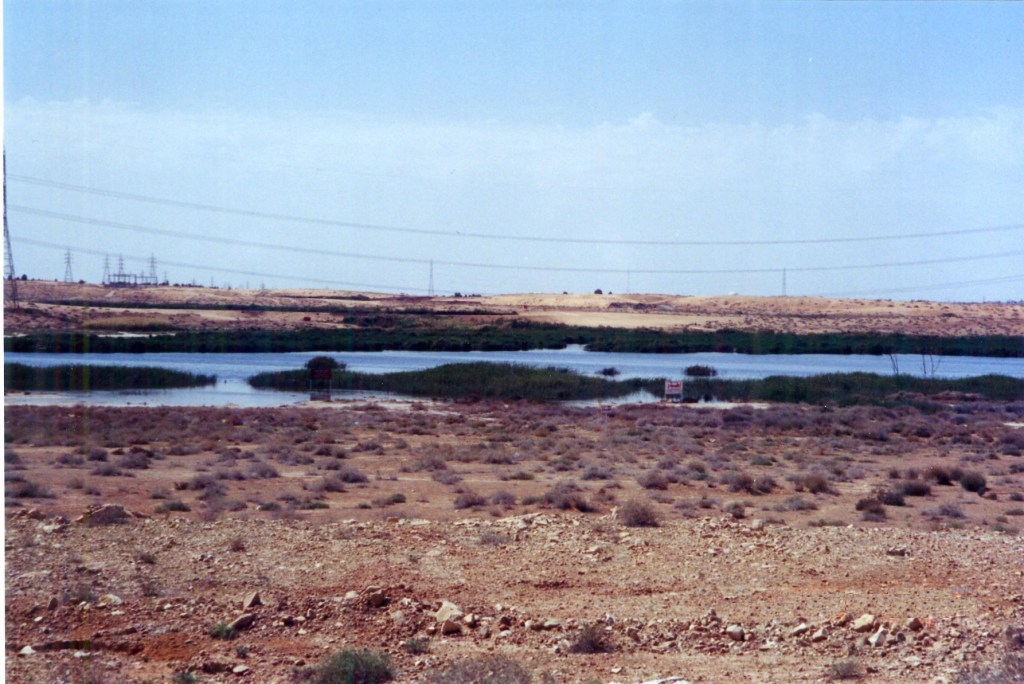
The streams that flows into the Arabian Gulf were overflow of irrigation water from both Al the Qatif and the Al-Hasa Oasises. Once the amount of spring water has decreased, those streams also have been disappeared.
涸れ谷バーティン・ルマ水系
Wadi al Batin / ar Rumah system
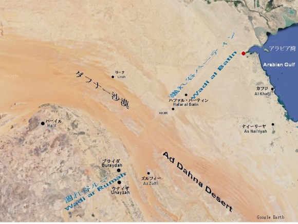
Wadi ar Rumah and Wadi al Batin are apparently separated by the Ad Dahna Desert, however the flow is thought to continue as shallow water (shallow underground water)
涸れ谷カハド、涸れ谷ジフィン、涸れ谷ヒルムール、涸れ谷ジャリール等、ヒジャーズ山脈の内陸側に並ぶフタイム熔岩地帯、ハイバル熔岩地帯、キシュブ熔岩地帯等から東側の流水域を合わせ、カスィームを抜け、ハファル・バーティンからシャットゥルアラブ川河口方面へと流れていました。
Harrat Hutaym, Harrat Khaybar, and Harrat Kishb line with the inland of the Hijaz Mountains. The drainage basin of the Wadi al Batin/ar Rumah system is in these lava areas and their eastwards. This system collects the streams of tributaries such as Wadi al Jifin, Wadi Hirmul, and Wadi Jaree, etc. Then it flowed through Al Qasim, and also Hafar al Batin toward the mouth of the Shatt al-‘Arab.

A plain near Kabshan, upstream of Wadi Hirmul, a tributary of Sha’ib ad Dath whichi is the southern branch of Wadi ar Rumah.
浅瀬を跳ねて渡って行くほど大発生していました。
In the south of Buraydah, a part of the old riverbed had become sewage pools, in which Tilapia that escaped from the fish farm was so largely outbreak that a great number of fishes were bouncing in a shallow water and/or bank and pushing each other.

A scene of Wadi Hafal al Batin after the rain near the city of Hafal al Batin.( By Mr. Gal.Shammari)
涸れ谷サフバー水系
Wadi as Sahba system
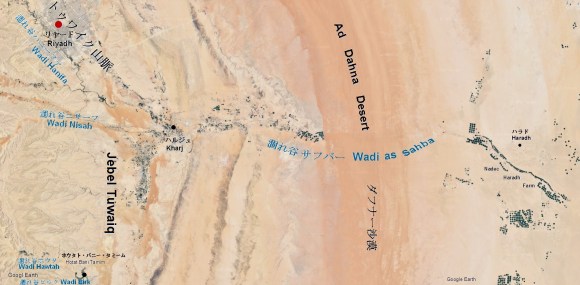
Wadi as-Sahba runs by cutting through Jebel Tuwaiq and dividing Ad Dahna desert
ナジュド中央部のトゥワイク山脈を東へと抜けた涸れ谷ニサーフ、涸れ谷ハウタ、涸れ谷ビルクと北からの涸れ谷ハニーファをハルジュで集め、東へとハラドを抜け、カタール半島つけ根部の南へと流れていました。
Wadi Nisah, Wadi Hawtat, Wadi Birk, etc., cut through Jebel Tuwaiq running the central part of the Najd region from north to south at south of Riyadh. Those wadis merge at Kharj to form the Wadi as Sahba system. It further merge Wadi Hanifa from the north. Then it flowed east through Haradh to the southern base of Qatar Peninsula.


涸れ谷ダワースィル水系
Wadi al Dawasir system

ナジュド南西部は北からは、涸れ谷ビーシャの流水域、南からは涸れ谷タスリースの流水域で覆われています。 二つのの涸れ谷は、ダワースィル市で合流し、東へ流れ、南西の古代都市跡のカルヤ・ファーウから流れ込む涸れ谷ヒンウを合わせます。 それからルブア・ハーリー沙漠を縦断してサウジ・オマーン国境の大流砂地帯ウンム・サミームへと流れていました。
The southwestern part of Najd is covered with 2 wadis water basins. Wadi Bisha covers from the north, and Wadi Tathlith covers from the south. The two Wadi meet at the city of al Dawasir and flows eastword. Then Wadi al Hinw joins from the southwest, which is the direction of the ancient city of Qaryat al Faw. Then it traverses the Rub’al Khali desert to the large quicksand of Umm al Samim on the Saudi/Oman border.

A large reiver bed of Wadial Dawasir extending deep into the eastern part of the “Empty Quarter”.
The ancient city ruins of “Qaryat al Faw” on the right bank of Sha’ib al Faw of the up stream of Wadi al Hinw..
涸れ谷ミヤー水系
Wadi al Miyah system
上記の三大水系と比べると規模は小さいですが、シャルキーヤ地方(サウディアラビア東部州)を流れる涸れ谷がもう一つあります。それが涸れ谷ミヤーです。ダフナー沙漠の東側にはスンマーン台地と呼ばれるカルスト台地がダフナー沙漠と並行するように延びています。降雨等は、この台地の集水域を東に流れて涸れ谷ミヤーに流れ込みます。涸れ谷ミヤーは,ダンマーム西南西135kmに位置するウライイラ村付近から北へと150km流れてナイーリーヤの南でアラビア湾に注いでいました。
Although it is smaller than the above three major water systems, there is an another Wadi valley. It runs through the Ash Sharqiyah region. That is Wadi al-Miyah. To the eastward of Ad Dahna, the Karst Plateau (Limestone Floor) extends parallel to it and is called As Sunman Plateau. Precipitation and the likes flowed east, through the water basin on this plateau, into Wadi al-Miyah. Wadi al-Miyah flowed 150km north to As Nai’riyah from the vicinit of ‘Uray’Irah village, 135 km west-southwest of Dammam, and poured into the Arabian Gulf.
紅海に注ぐ涸れ谷
Wadis flowing into the Red Sea

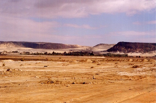
Near the mouth of Wadi Aba Al Qizaz, 90km south-southeast of Dhuba

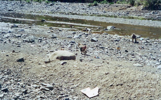
A flock of baboons is playing in the stream of Wadi Dili’ descending west from Abha.
紅海側に注ぐ涸れ谷は、サラワート山脈を水源としており、流れの距離も短く、大きな水流には成りません。それでも涸れ谷ハリーおよび涸れ谷バイシャ等の水系があります。アフリカから紅海をわたる西風がサラワート山脈を越える際に降雨をもたらすので、水の流れが見られる涸れ谷も少なくありません。比較的大きな水系としては、唯一、ナジュド側からサラワート山脈を越えて北北西へと紅海へ注ぐ涸れ谷ハムドがあります。
The wadis that pour into the Red Sea use the Sarawat Mountains as its water source, and the flow distance is relatively short, so that it does not become a large wadi. Still, there are water systems such as Wadi Hali and Wadi Baysha. The westerlies, that cross the Red Sea from Africa, put rainfall when they cross over the Sarawat Mountains. Therefore, there are several wadis that has the flowing-water. The relatively large water system is the Wadi Hamd. It is only one wadi which flows from the Najd side across the Sarawat Mountains. It collects water in the surrounding area of Madinah passes through the Sarawat Mountains and flows north-northwest to the Red Sea. Wadi al Jizl system collects water around Al-`Ula and flow south to join to the Wadi Hamd at near the pass.
涸れ谷ハムド水系
Wadi Hamd sysytem

涸れ谷ハムド水系は、サラワート山脈を越えてナジュド地域から紅海へと注ぐ唯一の涸れ谷であり、紅海に流入する涸れ谷の中で最も広い流水域を持っています。ラハート熔岩地帯、ナーイマ熔岩地帯、マルワ山、キシュブ熔岩地帯に囲まれた涸れ谷シュウバ水系の降水量は、ハダウダー河床に集まり、涸れ谷ハナクによってマディーナを通って涸れ谷ハムドに排水されます。ハダウダー河床は、マディーナの東約40kmから南東に伸びています。涸れ谷アキーク等も南からマディーナで涸れ谷ハナクに合流します。 涸れ谷ハムド水系にはサラワート山脈を越える辺りで、涸れ谷ジズルが北から合流します。涸れ谷ジズルは、北東のウラー渓谷を含む、ウワイリド熔岩地帯の両側に集水域を持っています。
The Wadi Hamd system is the only wadi that flows from the Najd region to the Red Sea across the Sarawat Mountains and has the widest water basin in the wadis that flow into the Red Sea. Surrounded by Harrat ar Rahat, Harrat Naimah, Jibal Al Marwah and Harrat Kishb, water precipitation of the Wadi Shu’abah system gathers on the Qa’ Hadawda riverbed and is drained by Wadi al Khanaq through Madinah to Wadi Hamd. The Qa ’Hadawda bed is extends southeast from around 40 km east of Madinah. Wadi al Aqiq, etc also join Wadi al Khanaq from the south at Madinah. Wadi Hamd system crosses the Sarawat Mountains and at the same time Wadi al Jizl joins form north. Wadi al Jizl has catchments on both sides of Harrat Uwayrid, including the northeastern Al Ula Valley. Then, Wadi Hamd flows down to northwestward in the direction of its river mouth located 45 km south-southeast of Al Wajh.
涸れ谷ハリー水系
Wadi Hali system
涸れ谷ハリー水系は、サラワート山脈の西壁とビルク熔岩地帯の間で水を集め、クンフザの南南東55kmのハリーに向かって北に流れ、紅海に注いでいます。 サラワート山脈のこの部分は、スーダ山地とタヌマ北の間にあります。 スーダ山地は、サウジアラビア領内で最も高い尾根であり、アブハの北西に位置しています。
The Wadi Hali system collects water between the west wall of the Sarawat Mountains and Harrat al Birk, flows north to Hali 55km south-southeast of Qunfudhah, and poures into into the Red Sea. This part of Sarawat Mountain is between As Sudah and Tanumah north. As Sudah is the highest ridge in the territory of Saudi Arabia and is located northwest Abha.
涸れ谷バイシャ水系
Wadi Baysha system
涸れ谷バイシャは、ダハラーン・ジャヌーブを源頭として、サラワート山脈とファイファー山地等のティハーマ山稜で囲まれた広い谷を集水し、ジーザーン北30km付近で紅海に流れ込んでいます。
Wadi Baysha, which originated from Dhahran Al Janoub, collects water in a wide valley surrounded by Sarawat Mountains and Tihama Ridge such as Fayfa Massif, and flows into the Red Sea near 30 km north of Jazan.
その他
The other systems
紅海岸の涸れ谷にはその他のには北からアカバ湾と平行してナバテア遺跡バダアを流れる涸れ谷アファール、バドルフナインを通る涸れ谷ムフィイタ、メッカからジェッダ南へと流れる涸れ谷ファーティマ、バルジュラシーからクンフザへ下る涸れ谷カヌーナ、バニー・アムルとナマース稜線からカウズへ下る涸れ谷ヤバー、アブハーからダルブへ下る涸れ谷ディリア等、幾多の涸れ谷があります。
In addition to the above three wadi sysytems, there are many other wadis that flow into the Red Sea. The main wadis among them are ; Wadi Afal, which flows from the north through Al Bad’ ,known as a Nabataeans archaeological site, parallel to the Gulf of Aqabah, and Wadi Mufiytah (Wadi as Safra), which flows through Badr Hunain. Wadi Fatimah flowing from Makkah to the southern Jeddah, Wadi Qanunah going down from Baljurashi to Qunfudhah, Wadi Yabah descending from the ridge between Bani Amruu and An Namas to Al Quz, Wadi Dili’ descending from Abha to Ad Darb, etc.
アラビア海およびアデン湾に注ぐ涸れ谷
Wadis flowing into the Arabian Sea and the Gulf of Aden
アラビア海およびアデン湾に注ぐ涸れ谷は幾つかあります。それらの中でもハジャル山脈にある涸れ谷には風光明美で名が知れている涸れ谷も少なくありません。しかしながら、この海岸線での代表的な涸れ谷としては、その中央部に注ぎ、流域にシバーム、サユーンやタリム等の古代からの町が在る涸れ谷ハドラマウトが挙げられます。
There are several wadi that pour into the Arabian Sea and the Gulf of Aden. Among them, some wadis in the Al-Hajar Mountains are known for their scenic beauty. However, a notable wadi among them is the Wadi Hadhramaut. It is poured into its central part of on this coastline and has ancient towns such as Shibam, Sa’yun and Tarim in its water basin.
涸れ谷バニー・カーリド
Wadi Bani Khalid
涸れ谷バニー・カーリドは、オマーン東部を代表する涸れ谷でハジャル山地の西側に広い幅の水域を持ち、年間間を通じて水の流れがあり、幾つもの淀みもあります。流域に石灰岩地帯があるので風光明媚な観光地としても知られています。源頭はカンダル山の北西30km付近でそこからハジャル山地の西側をハッド岬(ラアス・アル=ハッド)の南南西80kmにある漁村アシュカラへと流れて、その村の北でアラビア海に注いでいます。
Wadi Bani Khalid is a major wadi of the eastern Oman, and has its watershed in the western foot of Al-Hajar Mountains. It has the water flow throughout year and also has several water stagnations. It is also known as a scenic tourist destination because of its beauty in the harmony of water and limestone in its water basin. It origins about 30km northwest of Jebel Khandar, then flows along the western foot of Al-Hajar Mountains to the fishing village Al Ashkharah, 80km south-southwest of Ras al-Hadd, and pours into the Arabian Sea at the northern beach of this village
涸れ谷アンダーム
Wadi Andam
涸れ谷アンダームはダーヒリーヤ行政区のサマーイル州付近を源頭としてシャルキーヤ地方北部を同地方のムダイビへと流れています。海から遠く離れた内陸の流域は、緑に囲まれ穏やかな静けさに安らぎを感じさせられる観光スポットにもなっています。時として、その流れは、ワヒーバ沙漠の西側を流れて、ウスタ行政区でも漁村の多いマフート州に達することもあります。
Wadi Dhahawn is also known as Wadi Dawan. Wadi runs through Yemen’s Al Mahrah Governorate. From near the western end of Jebel Mahrat, it flows 40 km east-southeast to Al Muaqarqar, then flows 50 km south to Ariqim, again flows 100 km east Al Ghaydah. It pours into Arabian Sea, there. Al Mahrah Governorate has its office in Al Ghaydah and is adjacent to Oman’s Dhofar Governorate
涸れ谷ザハウン
Wadi Dhahawn
涸れ谷ザハウンは、涸れ谷ダウアンとも呼ばれます。オマーンのドファール特別行政区に隣接いしたイエメンのマフラ県を流れる涸れ谷です。マフラ山地の西端付近から40km東南東のムアカルカルへ流れた後、南のアリキムまで50km下り、東へ100km流れて県庁のある ガイダでアラビア海に注いでいます。
Wadi Dhahawn is also known as Wadi Dawan. Wadi runs through Yemen’s Al Mahrah Governorate. From near the western end of Jebel Mahrat, it flows 40 km east-southeast to Al Muaqarqar, then flows 50 km south to Ariqim, again flows 100 km east Al Ghaydah. It pours into Arabian Sea, there. Al Mahrah Governorate has its office in Al Ghaydah and is adjacent to Oman’s Dhofar Governorate.
涸れ谷ハドラマウト
Wadi Hadramaut system
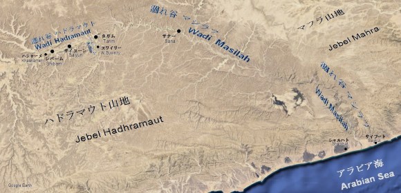
涸れ谷ハドラマウトは、イエメンを代表する肥沃な涸れ谷で、古代から人々が定住し、摩天楼の様な高い日干し煉瓦の家々が特徴的で、平均幅2㎞ 最大深さ300mもあり、シバーム、サイユーン、タリム等の町が古代から営まれてきています。この涸れ谷は、シバームの西5kmのハシャーメル付近を源頭として東に流れ、シバームの東40kmのスワイリーで、南から涸れ谷アディムが合流して、本流はその名を涸れ谷マシラフに変えてタリムまで10km程度北上します。そこからサナーまでの70kmさらに東に流れて、サナーからマフラ山地とハドラマウト山地の間を東南に200km下ってサイフートとシャルハトの間の海岸でアラビア海に注いでいます。
Wadi Hadramaut is one of Yemen’s best known wadis. This wadi is fertile and has been settled by people since ancient times. High adobe houses, like skyscrapers, are the simbol of this wadi. It has an average width of 2 km and a maximum depth of 300 m, and the towns such as Shibam, Sa’yun, and Tarim have been run since ancient times. This wadi begins in the vicinity of Khashamer, 5 km west of Shibam, and flows east, and at Al Suweiry, 40 km east of Shibam, Wadi Adim joins from the south. From there, the main stream changes its name to Wadi Masilah and heads north for about 10 km to Tarim. It flows 70 km further east from there to Sana. From Sana, Wadii Masilah passes through the valley between Jebel Mahrat and Jebel Hadhramaut, further flows down to 200 km southeast and then pours into the Arabian Sea at the coast between Sayhut and Sharkhat.
涸れ谷アフワール
Wadi Ahwar
涸れ谷アフールは、イエメン南部では主要な涸れ谷です。アビヤン県を流域としており、アフール村でアデン湾に注いでいます。
Wadi Ahwar is a main wadi in South Yemen. It has a water basin within Abyan Governorate and flows to Ahwar village and pours into the Gulf of Aden.
涸れ谷バナー
Wadi Bana
涸れ谷バナーは、イエメン南西部では主要な涸れ谷です。イエメンでは西部山地とも呼ばれているサラワート山脈南部山塊の南斜面を下り、アビヤン県を主な流域としてしています。この涸れ谷はアビヤン県の県庁所在地ジンジバールへと流れてその南でアデン湾に注いでいます。この涸れ谷の流域では降雨量が多く、河口域を中心に農地が発達しています。
Wadi Bana is a main wadi in the southwestern Yemen. It descends the southern slopes of Sarawat Mountains, also known as Western Mountains in Yemen. its main water basin is within Abyan Governorate. This wadi flows to Zinjibar, the capital of Abyan Governorate, and then pours into Gulf of Aden. There is a lot of rainfall in this water basin, therefore the agricultural lands are developing mainly in the estuary and its surroundings.
内陸の涸れ谷
Inland Wadis
内陸の涸れ谷の多くはアラビア湾側の涸れ谷と同様にサブハや地下水路に流れ込んで終わっています。幾つかの涸れ谷を集めるサブハはリジュラと呼ばれ、その典型的な例としては涸れ谷スィルハーンの町タバルジャルがあります。その名タバルジャルもリジュラが語源となっているそうです。
サブハは水が注がれている間は、水を湛えて塩湖となり、乾燥してくると水が蒸発して表土が枯渇して固まります。平で地耐力もあり、キャラバン(隊商)や大型車両の通行も可能です。しかしながら、部分的に水の残っている個所もあり、一旦、嵌まると底なし沼の様な状態となります。その様な場所は流砂地帯と呼ばれ、昔からベドウインに恐れられてきました。半島最大のサブハ地帯であるウンム・サミーム(毒の母)の名もその恐れに由来していると思われます。
内陸の涸れ谷の終わりにはジュフラと呼ばれる場所もあります。ジュフラの前後では涸れ谷の流れの方向や名前が異なっており、そこが文字通りに水の流れが終わる場所である事がわかります。例としては空白地帯西縁のライラ北北西45kmのジュフラが挙げられます。涸れた池の様な外見をしていますが、鐘乳洞に通じる隠れた水路となっています。
砂丘地帯に流れ込む涸れ谷では不浸透層があれば、その上の砂層に水が地下水となって蓄えられ、湧水地を伴うオアシスを作り出している場所が多く見受けられます。この様な例にはラウダ・フライムを含むルマーフ(リヤード北北東115km)の井戸群が挙げられます。サラワート山脈では涸れ谷が山脈両側の熔岩地帯に流れ込む場合も少なくありません。紅海側では熔岩で漉された伏流水が海岸や海岸に近い海底で湧き出し、豊かなマングローブの林を育んできました。ナジュド沙漠側では熔岩からの水の湧き出しがマハド・ザハブ金鉱西に横たわる特異な景観のスワイルキーヤ湿地帯などを作り出しています。
海に流れ出ないで内陸で終焉する涸れ谷は小規模なものまで含めると数限りなくありますが、その内の主だったものとしては涸れ谷スィルハーン、涸れ谷アトク、涸れ谷ハブーナ、涸れ谷ナジュラーン等が挙げられます。
Most of the inland wadis, like the wadis on the Arabian Gulf side, end up flowing into Sabkha and/or the shallow underground waterways. Sabkha, which collects several wadis, is called al-Rijla, a typical example of which is the town of Tabarjal in Wadi’l-Sirhan. The name Tabarjal is also derived from al-Rijla. While the water is being poured,
Sabkha is filled with water and becomes a salt lake, and when it dries, the water evaporates and the topsoil is depleted and hardened. It is flat and has a enough bearing capacity for caravan and also large vehicles to pass through it . However, there are some areas where water remains, and once it fits in, it becomes like a bottomless swamp. Such places are called quicksand and have long been feared by Bedouins. The name of Umm al Samim (mother of poison), the largest Sabkha region on the peninsula, seems to be derived from that fear.
There is also a place called Jufra at the end of the inland wadis. Before and after Jufra, the direction and name of the wadis are different, and it can be seen as the place where the flow of water literally ends. An example is the Jufra, 45 km north-northwest of Layla on the western edge of the Rub’ al Khali desert. It looks like a dried pond, but it is a hidden waterway leading to the limestone cave.
If a wadi flows into the dune area, which has impermeable layer beneath the sand, water is stored as a shallow water (shallow underground water) in the sand layer above the impermeable layer. Such place creates an oasis with springs in many cases. An example of this kind is located at Rumah (115km north-northeast of Riyadh) as many water wells, including Rawdhat Khuraym. In Sarawat Mountains, wadis often flow into lava areas on either side of the mountains. On the Red Sea side, lava-strained shallow water springs up on the coast and also the seabed near the coast, and has nurtured a rich mangrove forest. On the Najd desert side, lava springs create a unique landscape such as As-Suwayrqiyan wetlands west of the Mahd al Dhahab gold mine.
There are also innumerable wadis that end inland without flowing into the sea, including small ones. The typical inland wadis are Wadi’l-Sirhan, Wadi’Atk, Wadi Habunah, Wadi Najran, etc.
涸れ谷スィルハーン
Wadi’l-Sirhan

The area visible in the lower center of the image is the Tabarjal Large Agricultural Zone, which consists of countless center-pivot farms.
内陸型の閉じられた水系の最大規模なのは、涸れ谷スィルハーンです。幅20kmで総延長は380kmで、ドゥーマ・ジャンダル西30km付近を南南東の起点としてハッラ熔岩地帯の南西側に沿って、ヨルダンまで北北西へと延びています。ハッラ熔岩地帯はラジル熔岩地帯としても知られています。この涸れ谷は、スィルハーン窪地とも呼ばれているように流水によって侵食された谷では無く、もともとはジョウバ窪地と一体であった太古の海か湖だろうと云われています。それを裏付けるかの様に良質で大量な塩が産出できる鉱床があり、19世紀にはこの地域を占領していたオスマン帝国がこの鉱床を取り分け重視していた事が明確に記録してあります。スィルハーン窪地の全長に渡って多くの水井戸があり、タイマーより北にある最大のオアシスで、古代から隊商路として利用されてきました。
The inlands wadi are the closed drainage system. Their flows do not reach to the sea. Among such wadis in the peninsula, the largest one is Wadi’l-Sirhan. It is 20 km wide and has a total length of 380 km. Along the southwest side of the lava zone named Al Harrah, it extends north-northwest to Jordan. Al Harrah is also known as Harrat Al Rajil. As it is also called as the Al-Sirhan depression, this wadi is not a valley eroded by running water, but an ancient sea or lake that was originally integrated with the Al-Jawba depression. As if to support this, there is a deposit that can produce a large amount of high quality salt. It is clearly recorded that the Ottoman Empire, which occupied the area in the 19th century, placed particular importance on this deposit. Wadi’l-Sirhan has many fresh water wells throughout its length and is the largest Oasis north of Tayma. And therefore it has been used as a caravan route since ancient times.
警護するために1338年建造の建造しました。
The area is near the ruins of Fort Kaf located 10 km northeast of Al Qurayyat. The fort was built
by the Ottoman Empire in 1338 to guard the Wadi’l-Sirhan trade route.

Tabarjal is an important al-Rijal (catchment) in Wad`il Sirhan. There are now a plenty of large-scale farms, such as NADEC and JADCO. Those farms are mainly using “center pivot irrigation method “.

定常的に大規模な水抜が必要です。その水抜きの排水は、涸れ谷の一部をせき止めて貯水されています。
このため、周囲3kmで水深15mの淡水湖が生まれました。
To the north of Duma Jandal, a large date palm plantation were built in the wadi. Since it is originally a wetland, big scale drainage is required on a regular basis. The drainaged water is stored by damming a part of the wadi. For this, a freshwater lake was newly born with a circumference of 3 km and a depth of 15 m.
涸れ谷アルアル
Wadi Ar’ar, etc.
アラビア半島北部にはシリア沙漠へと流れ、ユーフラテス川の流域に加わる涸れ谷が幾つかあります。北部国境州で州都アルアルを流れる涸れ谷アルアルとその南東50kmで隣り合う涸れ谷アバー・カウルが比較的広がりのある水系を成し、冬場には水の流れが見られます。アルアル南南東150kmには涸れ谷ヒッルがそれらと並行するように同じくシリア沙漠へと流れています。
In the northern part of the Arabian Peninsula, there are several wadi valleys that flow into the Syrian desert and join the basin of the Euphrates. Wadi Ar’ar, which flows through the Capital city Ar’ar in the Northern Borders Province, and Wadi Aba al Qur, which runs 50 km southeast of it, adjacent to each other. These two are relatively wide water systems among them with the water runs in winter. 150km south-southeast of Ar’ar, Wadi al Khirr also flows to the Syrian Desert.
涸れ谷ダイリア
Wadi Dayri’
この半島中央北部のハーイルから南南西へは、アジャー山塊が連なっています。涸れ谷ダイリアは、そのアジャー山塊の赤黒い山肌が筋肉の様に盛り上がる花崗岩質の山肌の南東斜面の水系を集め、ハーイルを2分して北東流れ、ナフード沙漠とダフナー沙漠中間の砂丘地帯へと流れ込んでいます。
The Jibal Aja range located in the north central part of the peninsula. It runs from Hayil to the south-southwest. The Jibal Ajas range is also characterized by a red-blacky granite surface rising like trained muscles. Wadi Dayri’ collects the precipitation on its southeastern slope. Then, It flows to northeastern direction though the city of Hayil dividing it to two parts. Wadi Dayri’ reaches to the sand dune area and disappears. This area is the transition zone form the Nafud Desert to the Ad Dahna Desert.
涸れ谷アフダル
Wadi Akhdar
涸れ谷アフダルは、半島の西北部に残るヒジャーズ鉄道跡のカラア・アフダル駅舎跡から北西へタブーク盆地へと流れ込んでいます。なお、カラア・アフダル駅舎跡はマダーイン・サーリフ北192kmでタブーク市南東72kmに位置しています。
In the northwestern part of the peninsula, the remains of the Hijaz Railway are still there. Wadi al Akhdar flows from the Qa al’at al Akhdar ruins to northwest into Tabuk Basin along its abandoned railway and is ended. As the reference, the site of Qa al’at al Akhdar is located 192 km north of Mada’in Salih and 72 km southeast of Tabuk city.
涸れ谷アトク
Wadi ‘Atk
ナジュド地方では、涸れ谷スダイル等がトゥワイク山脈北部東斜面の水系を集め、涸れ谷アトクに流れ込みます。 涸れ谷アトクは、リヤドの北約120km付近でリヤド-カシム道路をほぼ直角方向に横切って、ダフナー沙漠の砂丘に向かって東に走っています。 その流れは砂丘に染み込み、消えてゆきますが、おそらくルマーフ井戸群やラウダ・フライム自然保護区などのオアシスの水源の1つになっている思われます。
In the Najid region, Wadi Sudayr and others collect precipitation on the northern eastern slopes of Jebel Tuwaiq and then flow into Wadi’Atk. Wadi’Atk runs eastward to the sand dunes of the Ad Dahna Desert across at right angles at the bridge, about 120km north of Riyadh, in the Riyadh-Qasim road. Its flow soaks into the dunes and disappears. Wadi’Atk is probably one of the water source for Oasis of the Rumah wells, the Rawdat Khuraim natural reserve., etc.

涸れ谷リーヤ
Wadi Liyyah
涸れ谷リーヤは、サラワート山脈東斜面を集水してターイフの東を抜け、メッカ新街道と並行して、北東へ85km付近まで流れて、ジャラド堆積平原に消えています。なお、ジャラド堆積平原はそこからさらに北東へと広がっています。
Wadi Liyyah collects precipitation on the eastern slopes of the Sarawat Mountains, passes east of Taif, and flows around 85km northeast in parallel with New Mecca Road. Then it disappears in the Al-Jarad depositional plain. As for reference, this plain expands to the further same direction from there.
スバイウ水系および涸れ谷ランヤ
Wadi Subay and Wadi Ranyah
涸れ谷スバイウと涸れ谷ランヤは、共にサラワート山脈のターイフ・バーハ間の山稜から北東斜面を集水する涸れ谷です。涸れ谷スバイウは上流部の涸れ谷トゥルバと涸れ谷フルマが合流した後はトゥルバ(ターイフ東130km)からフルマ(ターイフ東北東180km)まで道路に沿って流れ、フルマの下流で東に向きを変えて、スバイウ砂丘地帯へ消えて行きます。涸れ谷ランヤはナワーシフ・ビクーム熔岩地帯を挟んでその南東側を涸れ谷スバイウと並行してランヤ(ターイフ東250km)へ流れ、スバイウ砂丘地帯へと消えて行きます。涸れ谷スバイウと共にかつては涸れ谷ダワースィルの水系の一部であったと思われます。
Wadi Subay and Wadi Ranyah are both drainage valleys that collect precipitation in the northeastern slope of the ridge between Taif and Al-Bahah. The said ridge is a central part of the Sarawat Mountains. The upper reaches of Wadi Subay, such as Wadi Turbah and Wadi Khurmah merge at Turbah,130km east of Taif . Then Wadi Subay flows straight along the road from Turbah ,130km east of Taif to Al Khurmah,180km east-northeast of Taif . It turns east at downstream of Al Khurmah and disappears into the Uruq Subay dune area. Ranyah flows in parallel with Wadi Subay to Ranyah, 250 km east of Taif as sandwiching the Harrat Nawasif- Buqum lava zone. Then, it disappears into the Uruq Subay dune area. It is said those two wadis are once a part of the Wadi al Dawasir system.

涸れ谷ハブーナ・ナジュラーン
Wadi Najran and Wadi Habunah
サラワート山脈のダハラーン・ジャヌーブからナジュラーン方面へ延びる支稜があります。涸れ谷ナジュラーンは、その南側の谷間を集水して、シャルーラへ向かう道路沿いに東へ流れ、農業地帯を潤しながらナジュラーンから60km付近で、ルブア・ハーリー沙漠の砂丘地帯に消えて行きます。ナジュラーンの20km余上流には1982年の創業した貯水量8,500万トンの治水用のナジュラーン渓谷ダム(Al Madhiq Dam)が設けられています。ダムサイトまでは長いトンネルで抜けられ、観光地にもなっています。1mを越えるような大きな魚影もあることから資源の豊かさを感じられます。
涸れ谷ハブーナはこの尾根の北側の谷を集水しています。涸れ谷ナジュラーンの北をほぼ平行に東へと流れる涸れ谷です。その中流域にタマリスクの広大な群生の見られます。ルブア・ハーリー沙漠に流れ込むとその下流は小さな玉石や砂利の原を意味するカドカーダと呼ばれる礫平原になります。さらに下流域はさまざまな火成岩の欠片が固い砂の中にモザイック模様を作り出しているジリダと呼ばれる平原となっています。
A branch ridge of Sarawat extends eastward from Dhahran Al Janoub toward Najran. Wadi Najran collects precipitation in its southern valley, flows east about 60 km along the road from Najran to Charula, irrigating the agricultural villages and disappearing into the dunes of the Rubua Harley. The Najran Valley Dam (Al Madhiq Dam), which was founded in 1982 and has a storage capacity of 85 million tons, is located 20 km upstream of Najran. A long tunnel can be reached to the dam site, making it a tourist destination. A large fish shadow shows the abundance.
Wadi Habunah collects precipitation in the valley north of this branch ridge. This wadi flows almost parallel to the north of Wadi Najran. A vast community of tamarisk can be seen in the middle reaches. When it flows into the Rub’al Khali, a gravel plain called Al Qadqadah, which means a field of small boulders and gravel, spreads downstream. Further downstream is a plain called Jilida, where various igneous rock fragments create a mozaic pattern in hard sand.
涸れ谷ジャウフ
Wadi Jawf Wadi
涸れ谷ジャウフは、サラワト山脈南部のサウジアラビアとイエメンの国境に近いサ‘ダ付近を源頭として山脈の西側に沿って東南へと下り、バラーキシュを通過すると涸れ谷マザブから涸れ谷ジャウフに名前が変わり、サイハド沙漠(ラムラト・サバ‘アタイン)に流れ込んでいます。
Jawf begins in the vicinity of Saada near the Saudi Arabia / Yemen border in the southern part of the Sarawat mountains, descends southeast along the west side of Sarawat, and after passing Balaqish, its name changes from Wadi Madhab to of Wadi Jawf. Then Wadi Jawf flows into Sayhad Desert (Ramlat al-Sab’atayn).
涸れ谷ムガシン
Wadi Mughshin
涸れ谷ムガシンは、オマーンのドファール特別行政区の海岸山脈(ドファール山脈 あるいはカラ山脈と呼ばれる)とルブア・ハーリー沙漠の南端を縁取る砂丘地帯の間を流れています。1946年に行われたウィルフレッド・セシガーによる 第一回ルブア・ハーリー沙漠(横断の出発点となっていたので、名前は知られていました。しかし、流路はあまりはっきりいていませんでした。最近のGoogle Mapによれば、千本柱の都市遺跡で知られたウバールの北北東65km付近を起点に国道31号線に沿って、そのほぼ10km程度北側を走りムガシン北20kmで、ドファール特別行政区とウスタ行政区の境界の西40km付近まで流れています。なお、2004年1月修正版の国連発行のオマーン地図にはこの流路に対して涸れ谷ビン・カワールとの記載があります。イエメンのマフラ県との国境付近の北にもムガシンという地名があり、涸れ谷ミターンがありますが、これは涸れ谷ムガシンではありません。
Wadi Mughshin is one of the inland wadis in Dhofar Governorate of Oman. Wadi Mughshin runs between the coastal mountains, called the Dhofar Mountains or Al-Qara Mountains, and the dune zone bordering the southern tip of the Rub’al Khali. Its name was known because it was the starting point for Wilfred Thesiger’s first crossing of the Rub’al Khali in 1946. However, its flow path is not very clear. According to the recent Google Map, It originates from around 65km north-northeast of Ubar. Ubar is known for the ruins of the City of the Thousand Pillars. After that, it runs parallel to the Route 31 with its north side. The distance between them is about 10 km. It ends 20km north of Mughshin, where is about 40km west of the border between Wusta Governorate and Dhofar Governorate. For reference, the January 2004 revised version of the Oman map published by United Nations states this flow path as Wadi Bin Khawar. There is also another place named Mughshin in the northeastern Al Mahrah Governorate of Yemen. There is Wadi Mitan close to it, but this is not Wadi Mughshin.
涸れ谷アイン
Wadi Ayn
涸れ谷アインは、アカダル山脈から南西にウンム・サミーム流砂地帯に流れる涸れ谷の一つです。前述のウィルフレッド・セシガーが立ち寄っていることや、上流のアイン村にあるハフィート期(紀元前3100年から2700年)のネクロポリスの墓遺跡で名が知られています。涸れ谷アインと並行して涸れ谷アスワド、涸れ谷アメアなどもウンム・サミーム流砂地帯へ下っています。
Wadi Ayn is one of the drainage valleys that flows southwest from The Jebel Akhdar Mountains into the Umm al Samim quicksand. It is known for the aforementioned Wilfred Thesiger stopover and the necropolis tomb ruins in the upper Hafit period (3100–2700 BC) in the village of Ayn. In parallel with Wadi Ayn, Wadi Aswad, Wadi Amair, etc. also descend into the Umm al Samim quicksand area.
旅客機の中から見た中東の河
Observing the rivers of the middle east
旅客機の中から中東の河を眺めるとチグリス・ユーフラテス川もナイル川も樹木が生えているのは川岸だけで、そこから十数メートル離れると全くの沙漠であるのに気付かされます。これは川岸や川底に沈泥が堆積し、土管を半割りにした中を水が流れている様な状態になっている為です。
涸れ谷も基本的には同じで、砂に満たされた半割りの土管構造に集水された水は、川面が乾いていても散逸しないで涸れ谷を伏流水となって流れています。この為、平らな場所や、小さな涸れ谷でも流れの真ん中にアカシカ科のタルフやサラム、さらにはタマリスクが谷筋に沿って点在し、その存在が分ります。中でもナジュラーン北の涸れ谷ハブーナに群生するタマリスクは、数キロ単位に広がり圧巻です。涸れ谷がある程度の大きさになるとその中にタルフ、サラムやタマリスクに加えてデイツの疎林や農地が作られます。
沙漠では降雨は少なく散発的ですが、一旦降り始めると短期間の豪雨となり、鉄砲水がとうとうと流れ出す事があります。半島では鉄砲水被害防止の為に多くのダムが作られています。ナジュラーンのマズィーク・ダム、サカーカーのジョウバ窪地人口湖等、水を湛えたダム湖を形成する程に水量の多い涸れ谷は少なくありません。でも多くの場合は涸れたダム湖の湖底を中小規模の農地にして湖底に井戸を掘って灌漑水を確保しています。たとえ灌漑水が給水出来ても、水量はせいぜいダム湖の周囲に中小規模のナツメ椰子園を営める程度です
Observing the rivers of the middle east, such as the Tigris / Euphrates Nile rivers from the passenger planes, trees are growing only on the banks of the rivers. And the desert is approaching until a few meters away along the riverbank. This is because silt has accumulated on the banks and bottoms of the river, and water is flowing in the river as if passing through the half-split clay pipe.
The wadi is basically the same flow pattern. The wadi water flows as if passing through the sand-filled half-split clay pipe. The water does not dissipate even if the wadi surface is dry, but continuously flows through the wadi as shallow water. For this reason, Tahlh (Acacia Gerratdii) and Salam (Acacia tortilis) of the Acacia family and/or Tamarisk (Athel tamarisk or Tamarix aphylla) are scattered along the wadi line in the middle of the stream even on a flat plain or a small wadi. If we can not visually recognize the wadi, those trees show us its existence. One of the masterpieces is Wadi Habunah, where Tamarisk, grows and spreads over several kilometers. Wadi Habunah locates in Najran north. When the wadi reaches a certain size, farmlands of crops and/or forests of date palm are created in it in addition to Talhk, Salam, Tamarix etc.
Rainfall is low and sporadic in the desert, but once it begins to rain, it becomes a short-term heavy rain, and flash floods may finally flow out. Many dams have been built on the peninsula to prevent flash flood damage.In some cases, there are enough water to form dam lakes filled with water, such as Najran’s Al Madhiq Dam and Sakaka’s Al-Jawba Reservoir, however, in many cases, those dam lakes are dried. Therefore their bottoms are used as small and medium-sized farmland. Wells are usually to be dug in their bottoms to secure irrigation water to supplied for small and medium-sized date farms in and around those lakes.
