
Caves on the Arabian Peninsula


目次 (Index)
序文 (Introduction)
アラビア半島の基盤は、その形成の核となったアラビア楯状地(火成岩地帯)とその後に形成され、その上に積もった石灰岩を主とする堆積地帯とから出来ています。現在は、麦わら帽子を半割にした様に紅海を底としてその東側に凸型をして膨らむような形に残されているアラビア楯状地の地上に現われている部分をその約2倍の幅で堆積岩地帯が囲っています。
洞窟は、火成岩地帯に出来た熔岩洞窟(lava tube)と石灰岩地帯のカルスト地形(Karst)で形成された鍾乳洞や浸食作用によって形成された砂岩地帯の洞窟などがあります。熔岩洞窟(lava tube)は、熔岩地帯(lava zone)のあるサウジアラビアとイエメンに限られますが、鍾乳洞や砂岩洞窟は、アラビア半島全域で見られます。
洞窟は山肌等に入口のある横穴洞窟と陥没穴にしか入口の無い陥没穴洞窟に分けられます。洞窟内部にはどこも水平に近いトンネル状の場所は多いのですが、アラビア半島では山間よりも平原の方が専有面積が圧倒的に多いので、横穴洞窟よりも陥没穴洞窟の方が遥かに多いと、考えられます。
洞窟の数では面積の広いサウジアラビアが一番多いですが、大きさでは観光地化された洞窟では鉄道まで敷設しているオマーンの洞窟と思われます。クウェートとバハレインでは洞窟の存在は、掴めませんでしたが、アラビア半島全体での洞窟調査は、まだまだ道半ばなので、海中洞窟を含めて今後、発見される可能性は、大いと思います。
The foundation of the Arabian Peninsula consists of the Arabian shield (igneous rock zone) and the sedimentary zone surround it. The sedimentary zone is mainly composed of limestone, sand stone, etc that was formed after the Arabian shield and piled up on it. At present, the sedimentary rock area is about twice the width of the surface part of the Arabian shield. This part, in which is the Arabian shield appears on the ground like the feature of a half-split straw hat. The flat line is the Red Sea and expand to east in a convex and bulging shape.
Caves include lava tubes formed in the igneous rock zone and limestone karst caves (Karst) caves, as well as sandstone caves formed by erosion. Lava tubes are confined to Saudi Arabia and Yemen, where lava zones are located, while limestone caves and sandstone caves can be found throughout the Arabian Peninsula.
Caves are divided into side-hole caves with horizontal entrances on a mountainside or a hill side, and sinkhole caves with vertical entrance on the ground. In the Arabian Peninsula, the area occupied by the plains is overwhelmingly larger than that of the mountains, therefore, there are far more caves in sinkhole caves than in the side-hole caves. Even in sinkhole caves, there are many tunnel-like horizontal places.
Saudi Arabia has the largest number of caves, but in terms of size, it seems that Omani caves are dominated. The railway in caves has been laid up already for the tourist attraction. The existence of caves in Kuwait and Bahrain could not be grasped, but cave surveys in the entire Arabian Peninsula are still only halfway, therefore there might be a great possibility that they will be discovered in the future, including the caves under seawater.
サウジアラビアの洞窟
サウジアラビアでは、古代から暑さ、寒さ、そして沙嵐や砂塵嵐等からの避難場所として利用し、また、洞窟内にあるプールや流れを水源として使用してきました。610年頃、ヌール山(Jabal Al-Noor)の洞窟(Ghar Hira or Cave of Hira)でムハンマド(the Prophet Muhammad)が瞑想している時、天から大天使ジブリール(the Archangel Gabriel)(جبرائيل)が使わされ、聖典クルアーン(the Holy Qur’an)が啓示されました。これがイスラーム教の始まりと伝えられています。このように、洞窟利用の歴史は古くから行われてきました。サウジ国内にある洞窟の本格的な学術的な調査は、1999年にサウジ地質調査所(the Saudi Geological Survey)を設立され、ジョン・パインと博士(Dr. Jon Pint)などを中心とした研究班が結成された以降の事です。サウジ地質調査所は2003年にStancey Internationalから出版された「The Desert Caves of Saudi Arabia」を通じて、サウジでの洞窟調査を内外に発表しました。サウジ地質調査所はその後も調査を重ねて、これまでに250以上の洞窟を調査しています。現在は、サウジ観光・国家遺産委員会(the Saudi Commission for Tourism and National Heritage (SCTH))と協力して、洞窟の観光資源化も検討中です。
Caves on Saudi Arabia
Since ancient times, the natives have used it as a refuge from heat, cold, and sand-dust storms, and has used a pool and a stream in a cave, if available, as their water sources. Around 610, while the Prophet Muhammad was meditating in the cave Ghar Hira on Mount Jabal Al-Noor, the Archangel Gabriel (جبرائيل) was dispatched to him from heaven. The Holy Qur’an was revealed to the Prophet Muhammad by the Archangel Gabriel (جبرائيل) . This is said to be the beginning of Islam. In those ways, the history of cave use has been done since ancient times. The Saud Geological Survey was established in 1999 and then the full-fledged academic surveys of caves in Saudi Arabia were commenced with the cave research groupe led by Dr. Jon Pint, etc. In 2003, “The Desert Caves of Saudi Arabia” was published by Stancey International under the name of the Saud Geological Survey. With this book, the Saud Geological Survey reports his own cave surveys in Saudi Arabia both domestically and internationally. The Saudi Geological Survey has continued to investigate and has surveyed more than 250 caves so far. Currently, in cooperation with the Saudi Commission for Tourism and National Heritage (SCTH), the Saud Geological Survey is also considering turning the cave into a tourism resource.
スマーン・カルストの洞窟群
ズィルフィー(Az Zilfi)とジュベール(Al Jubail)の中間の東部州側にマアカラ(Ma’aqala)という部落があり、その周囲に始新世のウンム・ラデュマ石灰岩層(the Umm er Radhuma limestone formation)で形成されたスマーン・カルスト(the Summan karst)(the Ma’aqala karst)地形があります。このカルスト地帯にはダール・スルタン(Dahl Sultan) を始め、ダール・フレンドリー(Dar Friendly)、ダール・ルムルべ(Dhal Murubbeh)、苔の洞窟(Mossy Cave)、ダール・イフタン(Dahl Iftakh)等、一連の陥没穴鍾乳洞があります。これらは、マアカラ(Ma’aqala)周辺に古井戸が集中していることから類推し、最初は夕食用の皿程の小さな穴を探し当てたことが、契機となって発見されました。
The Summan Karst Caves
There is a hamlet called Ma’aqala on the eastern provincial side between Az Zilfi and Al Jubail. The Suman Karst was formed around it. The Summan karst mainly consists of the Umm er Radhuma limestone formation and also called the Ma’aqala karst.
The Suman Karst accommodates a series of sinkhole caves, such as Dahl Sultan, Dar Friendly, Dhal Murubbeh, Mossy Cave and Dahl Iftakh. These existences were inferred from the concentration of old wells around Ma’aqala, and those caves were discovered initially by finding a tiny hole which is only the size of a dinner plate.
ジャバル・カラ
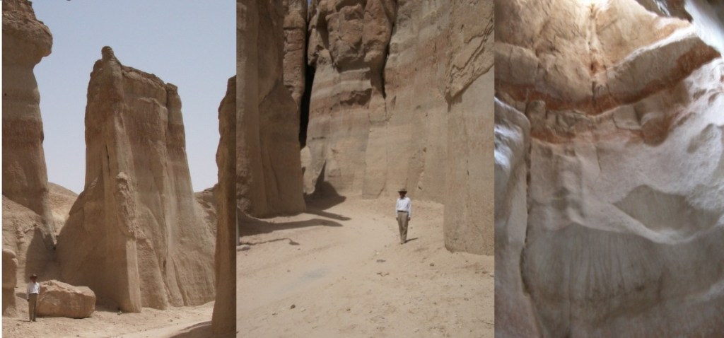
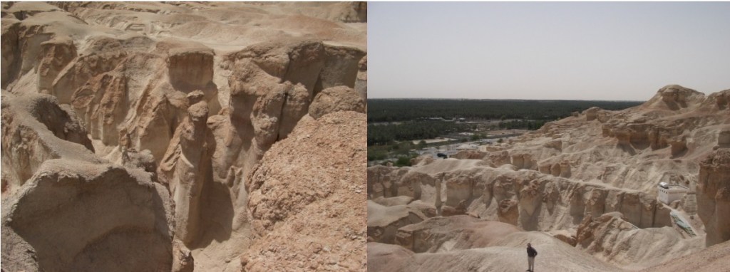
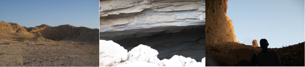
ハサー・オアシス(Al-Hasa Oasis)フフーフ(Hofuf)東10km付近の砂岩の岩山にある特異な横穴洞窟です。麓一面には広大なナツメヤシ園が広がっています。これらの横穴洞窟は、降った雨が、砂岩層を侵食して、茸型の岩を幾つも作り、それらを繋げて、谷間を作ってゆく過程ではないかと、筆者は思っています。もう一つの要因は、蒸発岩の存在です。蒸発岩は、岩塩、石膏、霰石等で構成され、挟みの様に砂岩層の一部となっています。その部分が水に溶かされ、空隙となっている場所を見ることもあるので、それが洞窟化を促進させるのだと思います。この洞窟を最初に訪れた時は、最初の階段を登って、暫く行った二股の天井は高いけれど狭い狭い大人一人横になってやっと通りられる洞窟のその先で人が昼寝していた空間がありました。その後に洞窟内の崩落があり、そこまで、奥まで入れませんでしたし、洞内を多少は照らしていた電球も消されていました。このため、狭いところでは足下が見えず、採光はずーと高いところにある自然の裂け目からの漏れてくる光だけでした。
Jabal Qarah
Al-Hasa Oasis has the characteristic side-hole cave located in the sandstone hill near 10km east of Hofuf. A vast date palm garden spreads all over the foothills. These side-hole caves might be the process that rain-fall erodes sandstone layers, creating a number of mushroom-shaped rocks, connecting them, and making a valley. Another factor is the presence of evaporative rocks. Evaporative rock is composed of rock salt, gypsum, aragonite, etc., and is part of a sandstone layer like a sandwich. There are the places where a part of them had been dissolved in water and made an empty space. This also promotes cave formation.
When I first visited this cave, I passed the first staircase and went deeper. While, its ceiling became too high and bifurcated, its passage became so narrow that only one adult could go through . Beyond that, there was a space where people were napping.
When I visited there at the second time, there was a collapse in the cave, and visitors were not able to go deeper in the cave. The light bulbs, that illuminate the cave to some extent, were also turned off. It was not possible to see under our feet in the narrow passage, and only daylight, leaking from the natural chasm at a high ceiling, assisted us.
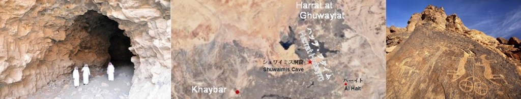
シュワイミス洞窟
ハイル地方の南西にある熔岩トンネル(Lava Tunnel)、シュワイミス(Shuwaimis Cave)(530メートル)は、ナワーシフ・ビクーム熔岩地帯(Harrat Nawasif- Buqum)のハバシ洞窟(Habashi Cave)(581メートル)とハイバル熔岩地帯(Harrat Khaybar )のウンム・ジャルサン洞窟(Umm Jirsan Cave)(1,500メートル)に次ぐ長さです。シュワイミス洞窟(Shuwaimis Cave)は、ハーイル州(Al Ḥa’il Province)のハーイト(Al Hait)(الحايط)の西北西40キロ付近で、フタイム熔岩地帯(Harrat Hutaym)にあるカドラ火山(Khadraa Volcano)山腹にあります。横穴洞窟であり、その開口部は、高さは11メートル、幅は16メートルあります。出入りが比較的容易で、内部にはアーチ型のホールがあり、洞窟内は温暖で、真ん中に小さな降雨通路があり、通気口にも成っています。この様な条件がサウジ観光国家遺産委員会(the Saudi Commission for Tourism and National Heritage (SCTH))が観光地化を検討している理由だと、思われます。
Shuwaimis Cave
Shuwaimis Cave is a lava tunnel in the southwest of the Heil region. Its length is 530 meters. This is the third longest lava tunnel after the 581-metre-long Habashi Cave in Harrat Nawasif-Buqum and the 1,500 meters of Umm Jirsan Cave in Harrat Khaybar. Khadraa Volcano in Harrat Hutaym is located about 40 km west-northwest of Al Hait(الحايط) in Al Ḥa’il Province. Shuwaimis Cave places on a mountainside of Khadraa Volcano. It is a side-hole cave with its opening of 11 meters high and 16 meters wide. It is relatively easy to get in and out, and there is an arched hall inside. The inside of the cave is warm, with a small rainfall passage in the middle that also serves as a vent. These conditions seem to be the reason why the Saudi Commission for Tourism and National Heritage (SCTH) is considering becoming a tourist destination.
アイン・ヒート又はダフル・ヒート
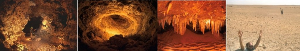
ジュバイル崖地(Jubayl Escarpment)は、リヤード(Riyadh)からハルジュ(Kharj)への高速道路の東に聳えています。その中間(リヤード南東35km、ハルジュ北西45km)には地底湖として知られていたアイン・ヒート(Ain Hit or Dahl Hit)があります。その入り口は崖地のほぼ麓にあり、30度以上もの急傾斜を降りて行きます。水面が地下水の汲み上げで地上から100m以上も下がっているために、到達する前に、洞内の暑さと暗さと湿気に耐えきれなくなり、筆者は引き返しました。ジュラ紀(145 – 208百万年前)および白亜紀に掛けての石灰岩層の鍾乳洞です。ここでは地表に無水岩と呼ばれる蒸発岩が見られます。この真珠のような灰色の岩には少し暗いシミが付いています。このシミが1938年にARAMCOの地質学者がタールのシミとして沙漠の半島で始めて発見した油兆であり、半島東部の油層を解読する為の重要な鍵と成りました。東部州でこの層を掘り下げて、沙漠の半島の莫大な原油埋蔵の最初の出油と成りました。現在では、洞窟ダイビング愛好家にとって、理想的場所となっているとの記事もあります。
Ain Hit or Dahl Hit
Jubayl Escarpment stands east of the highway from Riyadh to Kharj. In the middle (35 km southeast of Riyad, 45 km northwest of Harju), there is Ain Hit (Dahl Hit), known as an underground lake. The entrance is almost at the foot of the cliff and descends a steep incline of more than 30 degrees. Because the water surface was more than 100 meters below the ground due to groundwater pumping, I could not stand the heat, darkness and humidity in the cave before I reached water, so I turned back. It is a limestone cave of limestone formations of the Jurassic and Cretaceous. Here, evaporative rocks called anhydrous rocks can be seen on the surface. This pearly gray rock has some slightly darker stains. These stains were first discovered in 1938 by ARAMCO geologists on a desert peninsula as some tar stains, and they became an important key to deciphering the oil reservoir in the eastern part of the peninsula. Digging into this layer in the Eastern Province, it became the first oil release of the vast oil reserves of the desert peninsula. Some have said that it is now an ideal place for cave diving enthusiasts.
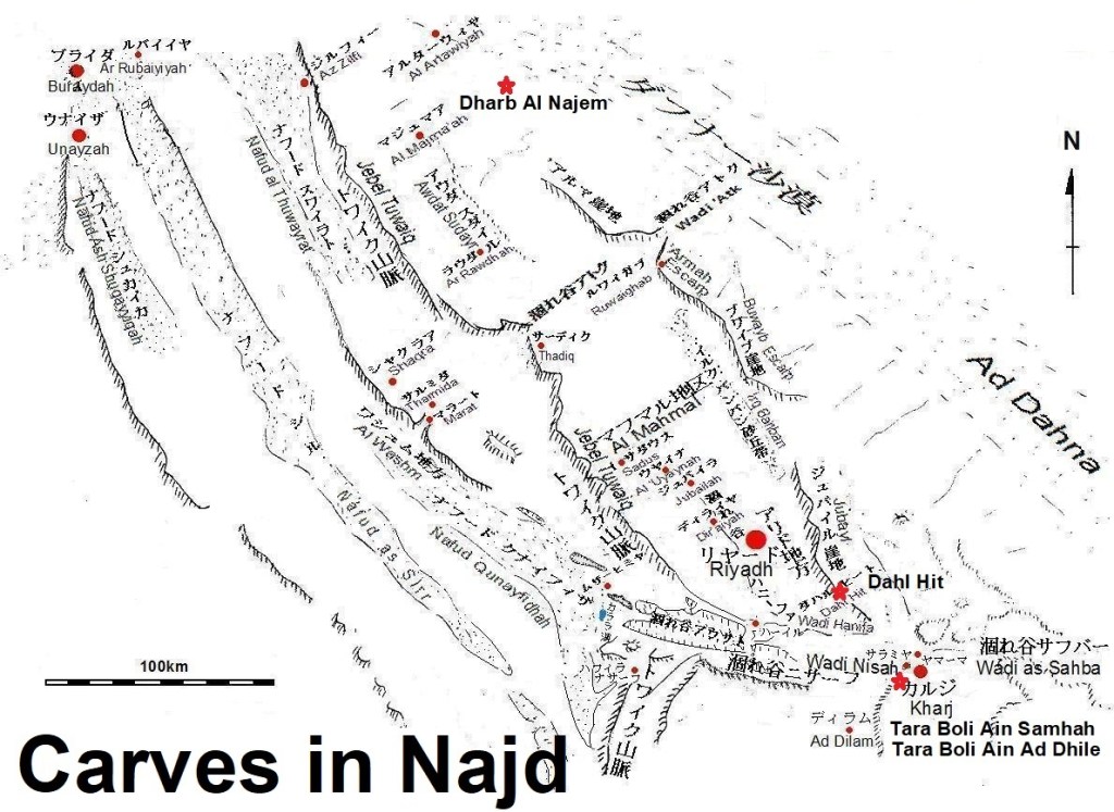
星の落ちた巨大な穴(垂直洞窟)
横穴洞窟は、昔から様々な生活用途に利用されて来ていますが、巨大な竪穴(陥没穴洞窟)は、「星の落ちた場所(Star Fell to Earth)」と呼ばれる以外にも「巨大な暗黒の吸い込み口(Huge Black Maw)」とも呼ばれ、現地の人達はイスラーム以前に多神教の神々とされていた精霊(Jin)が棲む場所として余り近寄らなかったようです。このため、自然のままに保存されて来ています。この様な洞窟にはナジェム垂直洞窟、アブルホル垂直洞窟やハルジュの陥没穴洞窟等があります。
The place of the fallen star
While Side-hole caves have been used for various living purposes since ancient times, huge pit hole (sinkhole cave) is called “Star Fell to Earth” or “a huge dark suction opening (Huge Black Maw)”, where the spirits (Jin) are believed to live in and locals didn’t get too close. The spirits (Jin) are considered polytheistic gods before Islam. Because of this, a lot of huge pit holes have come to be preserved in their natural states.
Such caves include Dharb Al Najem, Dahl Abu al Hol (Father of Fear) and Kharj’s Vertical Caves.
ナジェム垂直洞窟
ジョン・パイン博士(Dr. Jon Pint)は、ARAMCOの地質屋から「マジュマア(Al Majma’ah)近くに「星の落ちた穴(the place of the fallen star)」と呼ばれる巨大な竪穴がある」と聞き、1985年ダーラン(Dhahran)の石油鉱物大学(現在のKFUPM)で英語教師をして、週末に洞窟探しをしていた同博士は、スサナ・イバラ(Susana Ibarra)を伴い、友人とマジュマア(Al Majma’ah)に向かい、同地域出身の学生とその紹介のガイドを伴って、「星の落ちた巨大な穴(the place of the fallen star)」に向かいました。マジュマア(Al Majma’ah)から30キロ離れた、ウム・エル・ラドゥーマ地層(Umm al-Radhumah Formation)が断崖となっている崖地(escarpment)の近くで、巨大な四角いクレタ―を見つけました。その墨のような暗黒にロープで使って懸垂下降しました。100メートル下降したところでクレーターの底に辿り着きました。見上げると、降り口だった小さな四角の隙間から、光が差し込み、直径が100メートルに及ぶ、丸天井を持つ、大きなドームの底に降り立ったことが分かりました。これがナジェム(Dharb Al Najem)の発見でした。見上げると、次に下降中の友人は、蟻の大きさにしか見えませんでした。現地の人達は、こからハサー・オアシス(Al Hasa Oasisi)のホフーフ(Hofuf)まで地下水路で川が流れている。」と、話してましたが、その様な大きな水平トンネルはおろか、周囲の亀裂(cracks)を何度も覗き込みましたが、脇道の兆候(signs of a side passage)は発見できず、「ナジェム(Dharb Al Najem)は、独立した大きなドーム型の部屋である」と、ジョン・パイン博士(Dr. Jon Pint)は結論付けています。同博士は、この探索について、さまざまな発表してますが、所在については、明確に述べた記事はありません。私は、同博士の記述からジュバイル崖地から北北西へ’アルマ崖地へと続き、さらに北へ延長して来ている崖地の西側だと考えています。また、ナジェム(Dharb Al Najem)は、鍾乳洞と一応考えていますが、ジョン・パイン博士(Dr. Jon Pint)の「水平トンネルが無いとすると、この穴はどのようにして形成されたのでしょうか、もしかしたら、崩壊の大きなバージョンに過ぎず、さらに下に現地の人達が話していた、大きな地底の川があったかったのかも知れません。しかし、どうしてそれが起きたのか?そして、懸垂下降の途中で岩や石灰岩全くを見てないので、土の壁と天井だけで、どうしてこんな巨大な空っぽの空間が耐えられるのだろう?」との疑問には、今後の調査が待たれます。
Dharb Al Najem
Dr. Jon Pint was an English teacher at KFUPM in Dhahran in 1985 and spent weekend cave hunting. He said there is a huge pit called “the place of the fallen star” near Al Majma’ah according to the advice given by a geologist in ARAMCO. He went to Al Majma’ah with his wife, Susana Ibarra, and a friend.
So, accompanied by a student from the region and his introduction guide, he headed to “the place of the fallen star”, where is 30 km away from Al Majma’ah. Near the escarpment, where the Umm al-Radhumah formation forms a cliff, they found a huge square crater.
Dr. Jon Pint rappelled down with a rope in that ink-like darkness. After descending 100 meters, he reached the bottom of the crater. When he looked up, he saw that light came in through a small square gap that was the entrance to the crater, and he landed at the bottom of a large dome with a vaulted ceiling that was 100 meters in diameter. This was the discovery of Dharb Al Najem.
When he looked up, the friend, on the way to rappel down, was seemed only the size of an ant. The locals said that there is an underground river running from there to Hofuf, Al Hasa Oasisi. Dr. Jon Pint looked carefully at the cracks around the wall in many times, however he could not find any such a large horizontal tunnel, nor any signs of a side passage.
“Dharb Al Najem is a large, independent, domed room,” concludes Dr. Jon Pint. He has made various announcements about this search, but there is no clear article about its whereabouts.
I supposed that the escarpment ,extending further north from the Jubayl and ‘Armah escapements, is the escarpment described by him. Dharb Al Najem is a stalactite cave locating in its western side within the distance of 30 km from Al Majma’ah.
Dr. Jon Pint asked himself how did this hole form without the horizontal tunnel. Perhaps it was just a large version of the collapse, and the big underground river, that the locals were talking about, might exists further down.
How did it happen? And since he didn’t see any rocks or limestone during his rappelling, how can such a huge empty space withstand only the muddy walls and ceiling? Future investigations are awaited for those replies.

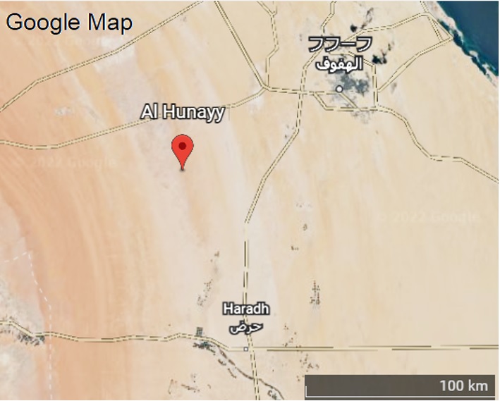
アブルホル垂直洞窟
ARAMCOの試掘要員(wildcatter)のレブリング氏(Mr. Leblings)とクリアン・ハジリ氏(Mr. Qurian Al-Hajri)が「ガワール油田(Ghawar Oil Field)の傍にも星の落ちた巨大な穴(the place of the fallen star)がある」と案内を申し出てくれました。位置的には、ジョン・パイン博士(Dr. Jon Pint)の記述からハラダ(Haradh)の北のアル・フナイ(Al Hunnay)集落の近郊と分かります。パイン博士(Dr. Jon Pint)一行は、1999年12月21日に彼らの案内でアブルホル洞窟(Dahl Abu al Hol )(Father of Fear)に向かいました。下降懸垂し、内部に入って調査した結果、深度は70メートルで、底部は100メートルの広く丸い部屋になっていて、その真ん中は急な砂の丘になっています。この垂直洞窟は、アインヒット(Ain Hit)の150メートル、ナジェムス垂直洞窟(Dharb Al Najem)の100メートルやアブスハイル(Abu Sukhayl)の75メートルに次いで。サウジアラビアでは4番目の深度があります。この部屋の上部3分の2は、石灰岩ですが、ナジェムス垂直洞窟(Dharb Al Najem)と同様に、石灰岩の溶解によって形成された洞窟ではありません。石灰岩層の下層に柔らかい鉱物の巨大な堆積物があり、これが溶解して巨大な崩壊を起こしたと考えられます。従って、現在の砂の床は、元の穴の底の相当上にあるのでしょう。底部の壁に脇道がありましたが、石灰岩ではありませんでした。数回曲がった先には、通り抜けは出来ませんでしたが、大きな部屋らしき部屋に開口部が見えました。
Dahl Abu al Hol (Father of Fear)
Mr. Leblings and Mr. Qurian Al-Hajri, who work on Aramco’s wildcatter, wrote that there is also “the place of the fallen star” near the Ghawar Oil Field, and he offered to guide Dr. Jon Pint there. Positionally, Dr. Jon Pint’s description tells us that it is near the Al Hunnay settlement north of Haradh.
Dr. Jon Pint and his group headed to Dahl Abu al Hol (Father of Fear) on December 21, 1999 with their guidance. As a result of rappelling down and going inside and investigating, this depth is 70 meters, the bottom is a wide round room of 100 meters, and the middle of it is a steep sand hill.
This vertical cave has the fourth deepest depth in Saudi Arabia after the three caves which are Ain Hit’s 150 meters, Dharb Al Najem’s 100 meters and Abu Sukhayl’s 75 meters.
The upper two-thirds of this room is limestone, but it is the same as Dharb Al Najem which is not a cave formed by the dissolution of limestone. It is thought that there is a huge deposit of soft minerals in the lower layers of the limestone formation, which melted and caused a huge collapse. Therefore, the current sandy floor is probably well above the bottom of the original hole. There was a side path on the bottom wall, but it wasn’t limestone. After a few turns, I couldn’t get through, but I saw an opening in what appeared to be a large room.
「アブルホル垂直洞窟(Dahl Abu al Hol )の発見をネット(on the web.)に掲載すると、すぐにハファル・バーティン(Hafar al-Batin)やハミース・ムシャイト (Khamis Mushayt)にも興味深い同じ様な洞窟があるとの連絡が入ってきました。」とパイン博士(Dr. Jon Pint)は述べています。
Immediately after posting the discovery of Dahl Abu al Hol on the web, Dr. Jon Pint was informed that Hafar al-Batin and Khamis Mushayt also have interesting similar caves.
ハルジュの陥没穴洞窟
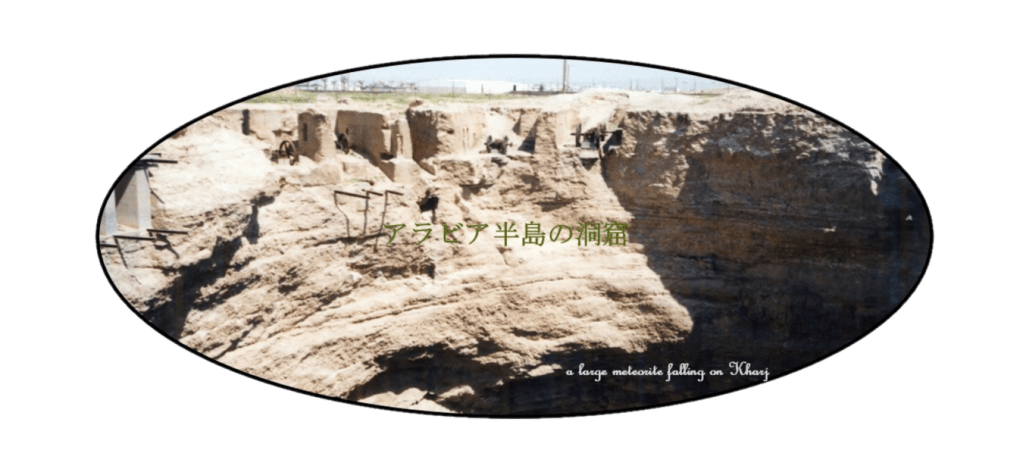
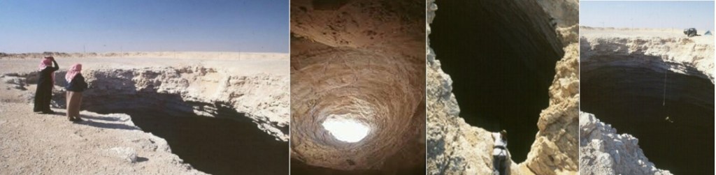
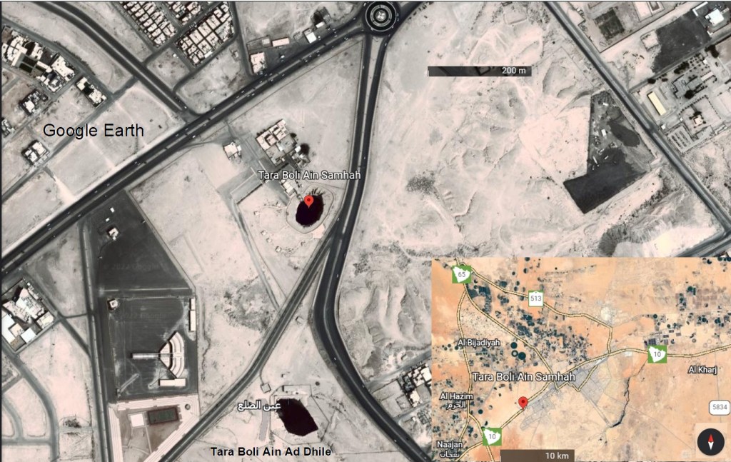
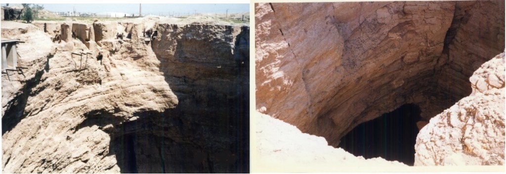
ハルジュ(Kharj)に大きな隕石が落ちて出来た垂直洞窟(Vertical Cave)があるとの話を聞いて、筆者は、1996年2月27日にそこを訪ねました。畑の奥に1930年にアラムコ(ARAMCO)がこの地域の灌漑用水汲み上げの為に設置し、今日も使われている水汲み用のポンプ小屋があります。その裏側に直径50メートルを超え、覗き込んでも底が見えないような巨大な竪穴(Crater)があり、そこに入れたホースで水を汲み上げていました。底が見えないので、その竪穴の縁まで行って覗き込むと、遥か下に黒く水面が見えました。陥没穴洞窟は、南に500メートル離れてた場所にも一つあります。現地の人達には「数千前に落下して来た隕石が穿った穴だ。」と語り継がれ、地球の隙間を意味する「目(عيون)」として知られています。それぞれにアインサムハ(Ain Samha) (عين سمحة)およびアインディラ(Ain of al-Dila)(عين الضلع)と名付けられていましいた。Ayuun as Seehや Ayuun an Najm等、他にも呼び方が幾つかあり、星が作ったロマンとは程遠いですが、正式にはTara Boli Ain Samhah and Tara Boli Ain Ad Dhileと定められました。
筆者は、周囲の石灰岩地層から「カルスト地形で出来た鍾乳洞の陥没穴洞窟だ」と、考えています。一時は、灌漑水として周囲の地層水(ground water)が大量に汲み上げられ、枯渇が懸念されていましたが、最近の大雨で水量が増え、現在は、覗き込まなくても水面が見えるようになっているようです。
Vertical Caves of Kharj
I heard that there is a Vertical Cave (sinkhole) formed by a large meteorite falling on Kharj, so I visited there on February 27, 1996. At the back of the field is a pump shed for water pumping that ARAMCO installed in 1930 for the pumping of water for irrigation in the area and is still used today.
On Its back side, there is a huge Crater with a diameter of more than 50 meters and Its bottom could not be seen even if you looked into it. Water was pumped up with a hose put in it. I couldn’t see the bottom, therefore I approached to its edge and looked into it. And then, I could see the black surface of the water far below.
There is also one another cave 500 meters to its south. The local people said that those are the holes pierced by a meteorite that fell thousands of years ago, and they are known as “eyes (عيون)” which mean gaps in the earth. They were named Ain Samha (عين سمحة) and Ain of al-Dila (عين الضلع), respectively. There are several other names, such as Ayuun as Seeh and Ayuun an Najm. Although it is far from the romance created by the stars, they are officially named as Tara Boli Ain Samhah and Tara Boli Ain Ad Dhile.
Because they are surrounded with the limestone formations, the author thinks that they are the stalactite caves, made in the karst terrain. At one time, a large amount of the ground water around them was pumped up as irrigation water, and there was the concern that it would be depleted. However, the amount of the ground water has increased due to recent heavy rains, and now it seems that the water surface can be seen without looking in.
ヒバシ熔岩洞窟
サウジアラビアではこれまでに14か所の熔岩トンネル(Lava Tube)が見付かっています。そのうちの最大の熔岩トンネル(Lava Tube)は、カーフ・シュワイミス(Kahf al Shuwaymis)です。長さ500メートル、幅16メートルで高さは11メートルあります。この熔岩トンネル(Lava Tube)は、ハイバル熔岩地帯(HarratKhaybar)北北東にあるグワイタート熔岩地帯(Harrat at Ghuwaytat)の北東部イスナイン熔岩地帯(Harrat Ithnayn)にあります。そこまでは大きくありませんが、ナワースィフ・ビクーム熔岩地帯(Harrat Nawasif- al Buqum)にあるヒバシ熔岩洞窟(Ghar al Hibashi)が熔岩トンネル(Lava Tube)としてもっともよく知れれています。長さ400メートルのほぼ水平で直線的な洞窟の幅は、15メートル以上あります。入口は小さな垂直孔で、側面に廊下につながっています。洞窟は地表から約6〜7 mのところにあります。洞窟の温度は20〜21°C、湿度は48%であるため、保存状態は良好です。洞窟は110万年前のものと推定され、溶岩鍾乳石、石筍、柱以外にも多くの骨や排せつ物が残されています。一部は自然発火もしています。そのため、ハイエナ、オオカミ、キツネ、コウモリ、鳥、家畜などの動物のデジェクタ(排泄物)または骨およびグアノ堆積物の生物起源石灰化に関連して鉱物も含めてこの洞窟内では少なくとも19種類もの洞窟鉱物が検出されています。その中には幾つかの希少鉱物を含まれています。
Ghar al Hibashi
So far, 14 lava tubes have been found in Saudi Arabia. The largest of them, the lava tube, is Kahf al Shuwaymis. It is 500 meters long, 16 meters wide and 11 meters high. This lava tube is located in Harrat Ithnayn, northeast of Harrat at Ghuwaytat, north-northeast of Harrat Khaybar.
It’s not that big, but Ghar al Hibashi in Harrat Nawasif-Buqum is best known as the lava tube. The almost horizontal and linear cavern with a length of 400 meters is more than 15 meters wide. The entrance is a small vertical hole, connected to the side of this corridor. The cave is located about 6-7 m beneath the the earth surface. The temperature of the cave is 20-21 ° C, and its humidity is 48%, so the state of preservation is good. The cave is estimated to be 1.1 million years old and contains many bones and excrement besides lava stalactites, stalagmites and pillars. Some of them have spontaneously ignited in the past. There are dejectas of animals, biogenically mineralized bones and guano deposits of animals such as hyenas, wolves, foxes, bats, birds and domestic animals in this cave. At least 19 types of cave minerals have been detected in this cave, including minerals related to biogenic calcification. Several rare minerals also found among them.
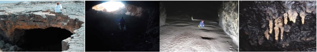
カタールの洞窟
カタール半島は、全体がkarst地形で形成されていますが、横穴洞窟はなく、陥没穴洞窟に限られています。全土的に知られるような洞窟は、3ヵ所あります。それ以外の陥没孔(sinkhole or doline)は、風で運ばれる砂塵で埋められたり、入り口が崩壊したりした小規模なものに限られているようです。アラビア楯状地(Arabian Shield)を取りまく、石灰岩層を大規模に含む堆積層帯の外周部なので、海底洞窟を含めて今後、発見される可能性はあると思います。
Qatar caves
The Qatar Peninsula is formed entirely by karst topography, but there are no side-hole caves and are limited to sinkhole caves (vertical caves or pit hole caves). There are three caves that are known throughout the country. Other sinkholes or dolines seem to be limited to small-scale ones filled with wind-carried dust or collapsed entrances. Since it is the outer periphery of the sedimentary layer zone surrounding the Arabian Shield and contains a large amount of limestone layers, there might be a possibility that the other caves will be discovered in the future, including undersea caves.
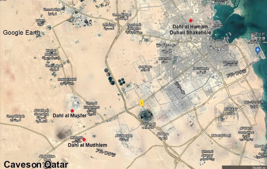
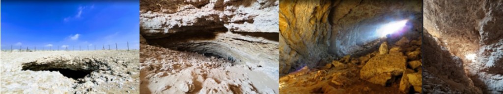
ダール・アル・ムスファー
この洞窟の深さは36メートルで急傾斜の長さは78メートルです。入口は崩壊がありますが、縦横それぞれ12メートルと4メートルです。ドロマイト(dolomite)と石灰岩の下はダンマーン下部層(Lower Damman Unit)とラス層(Rus Formation)に達しています。この洞窟はゴミ捨て場に近いのですが、ちょっとした丘もあり、岩壁登攀(bouldering)愛好者達が、訓練用のゲレンデとしても使っているようです。
なお、「ダール・アル・ムスファー(Dhal al Musfer)は陥没穴洞窟(sink hole cave)で、深さは100メートルあり、さらに下への広がりの可能性もある」とのOffbeat Qatarの記事があります。
Dhal al Musfer
The depth of this cave is 36 meters and the length of the steep slope is 78 meters. The entrance has collapses, but is 12 meters long and 4 meters width, respectively. Below the dolomite and limestone this cave reaches the Lower Damman Unit and the Rus Formation. This cave closely locates to a garbage dump, but there is also a small hill between them, and it seems that bouldering enthusiasts also use it as a practice cliff.
Note: There is an article by Offbeat Qatar that “Dhal al Musfer is a sinkhole cave, 100 meters deep, and may spread further down.”
ダール・アル・ムドレム
この洞窟は、Mukaynis, Al Rayyanにあります。ダール・アル・ムスファー(Dhal al Musfer)とは高速道路5号線(the Salwa Road)の反対側にある衛星地球ステーション(the satellite earth station)の南東に位置しています。この洞窟の長さは150メートルで深さは、30メートルです。入口は幅12メートルで、角度30度の砂交じりの傾斜通路(the sandy floor slopes)で。降ります。途中、狭まった場所があり、一時は通行できませんでした。洞内にはネヅミやコウモリの糞が貯まり、ゴキブリや黒い甲虫などが生息しています。昔は洞窟の底は水がたまり、放牧民に提供していましたが、今は枯渇しています。ドーハ(Doha)の西27キロ付近には岩の中に飲料可能な水ガメがあるそうですが、暗い洞窟の中なので明かりがないと、近づけないと言われています。
Dahl al Mudhlem
Dahl al Mudhlem is located in the southeast of the satellite earth station in Mukaynis, Al Rayyan on the other side of Dhal al Musfer along the Salwa Road. The depth of this cave is 30 meters, with a length of 150 meters. The entrance is 12 meters wide and has the sandy floor slope with an angle of 30 degrees. On the way down this slope, there was a narrow place, and it was impassable for a while. In the cave, rat and bat droppings accumulate, cockroaches and black beetles live. In the old days, the bottom of the cave was filled with water and served to grazing, but now it is depleted. There is another drinkable water pool in the rock about 27 km west of Doha, but it is in a dark cave so it is not approachable without light.
ダール・アル・ ハマーム
ハマーム陥没穴洞窟(Haman Sinkhole)とも呼ばれるこの洞窟は、ダール・アル・ ハマーム公園(Dahl al Hamam Park)内にあります。長さは60メートルで深さは15メートルです。入口は長径14.1メートル、短径9.1メートルの楕円形をしています。入口通路にはたくさんの崩壊ヵ所があり、岩、瓦礫が転がる砂交じりの緩い傾斜の砂利道なので入り難いです。一番底には数十メートル幅の汽水の水溜まりがあり、白っぽい殻で覆われています。その反対側には石灰岩の天井から澄んだ水が滴り落ちています。その先は、北東から南西方向のオーバル型の空洞で、4キロ先の海とつながっています。30センチ程度の干満があり、幾つかの種類の小魚も生息しています。
デュヘイル陥没穴洞窟(Duhail shakehole)は、ハマーム陥没穴洞窟(Haman Sinkhole)と隣り合ってはいますが、詳細は分かりません。
Dahl al Hamam
Also known as the Haman Sinkhole, the cave is located within Dahl al Hamam Park. It is 60 meters long and 15 meters deep. The entrance has an oval shape with a major axis of 14.1 meters and a minor axis of 9.1 meters. There are many collapse points in the entrance passage, and it is difficult to enter because it is a gravel road with a gentle slope mixed with sand where rocks and debris roll. At the very bottom there is a puddle of brackish water several tens of meters wide, covered with a whitish shell. On the other side of it is clear water dripping from the limestone ceiling. Beyond that, it is an oval-shaped cavity from northeast to southwest, connected to the sea 4 kilometers away. There is the ebb and flow of the tide of about 30 cm, and several kinds of small fish also live.
The Duhail Sinkhole is next to the Haman Sinkhole, but its details have not been available.

その他の陥没孔
下記の様に幾つかは分かっていますが、いずれも語句小さな陥没穴です。
ゴーシェイマ陥没穴(Al Ghosheimah Sinkholes)
相互に15~20メートル離れた竪穴の集団で相互につながっていると思われます。入口は2メートルから1メートル以下で長さも12メートル以下、深さも5メートル以下です。
クァサイラー(Al Quasairah)
このオアシスはカタール半島南の内海の北5キロ付近にあり、縦と横が30メートルと20メートルの植生のある囲いになっています。
サべリアット陥没穴(Al Suberiat Sinkholes)
径0.8mの入り口が2つあります。 陥没穴は深さ約3mです。2つの穴は約5m離れていますが、接続されており、穴はさらに続いているかもしれません。
デュハイル陥没穴(Duhail Sinkhole)
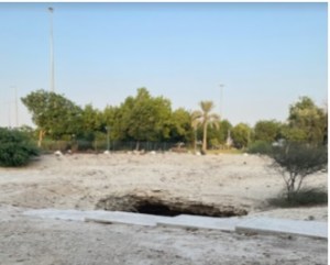
以前にドーハ市役所が40mメートル径のゴミ捨て場に使用していた穴で、長さ40メートルで、深さは5メートルです。
ウム・ カレイバ陥没穴(Um Kareibah Sinkholes)
二つの穴があり、片方は1.65メートル径の1メートル幅のドロマイトの壁で仕切られた開口部を2つ持っています。深さは3メートルで、径も2メートルまで広がっています。もう一つは、開口部が2メートルで深さ2.3メートルの陥没孔と径13メートルのドリーネ(sinkhole or doline)です。
(注)カタールの洞窟に関しては、ネットで調べている限り、情報が断片的なものが多く、まとめられないでいました。シェプトン・マレット洞窟クラブ(Shepton Mallet Carving Club)所属のマーティン・エリス博士(Dr. Martin Ellis)が2018年4月に発表した「カタールの洞窟(Caves in Qatar)」というレポートを読んで、やっと全体をまとめることが出来ました。同博士も洞窟学的情報(speleological information)がごく限られているとも述べています。
Other sinkholes
A few of them are known, but they are all small sinkholes.
Al Ghosheimah Sinkholes
It seems that they are connected to each other by a group of pits 15 ~ 20 meters apart. The entrance is from 2 meters to less than 1 meter, not more than 12 meters in length and less than 5 meters in depth.
Al Quasairah
This oasis is located about 5 kilometers north of the inland sea in the southern Qatar Peninsula and is surrounded by vegetation 30 meters long and 20 meters wide.
Al Suberiat Sinkholes
There are two entrances with a diameter of 0 .8m. The sinkhole is about 3 m deep. The two holes are about 5m apart, but they are connected, and the holes may continue further.
Duhail Sinkhole
It is a hole previously used by Doha City Hall for a 40m-diameter garbage dump, 40 meters long and 5 meters deep.
Um Kareibah Sinkholes
There are two holes, one of which has two openings with a diameter of 1.65 meters. They are partitioned by a 1-meter-wide dolomite wall. Another is a doline (sinkhole) with a diameter of 13 meters and it has an opening of 2 meters and a depth of 2.3 meters .
Note: As for the caves in Qatar, as far as the writer was looking up on the Internet, there were so many fragmentary pieces of information that he could not be summarized. After reading Dr. Martin Ellis’ “Caves in Qatar” reported in April 2018, he was finally able to put them all together.
Dr. Martin Ellis belongs to Shepton Mallet Carving Club. He also said that speleological information is very limited in Qatar.
