
A table comparing the climate of each region


目次
アラビア半島地域別の気候比較表
(1) アラビア半島における気候の概要
(2) 沙漠型気候BWh
(3) アラビア半島南東部における対流性の降水
(4) アラビア半島の地形的な特徴
(5) アシール山脈とは
(6) 降雨量低下と地球温暖化
(7) 総観気象
A table comparing the climate of each region of the Arabian Peninsula
(1) Overview of the climate of the Arabian Peninsula
(2) The Köppen climate classification as BWh
(3) Precipitation types in the southeastern Arabian Peninsula
(4) Topographical features of the Arabian Peninsula
(5) Name of the Asir Mountains
(6) Decreased rainfall and global warming
(7) Synoptic weather
アラビア半島地域別の気候比較表
A table comparing the climate of each region of the Arabian Peninsula
| Item | 夏 (Summer) | 冬 (Winter) | 降雨 (Precipitation) |
| 地方 Region | 特徴Characteristics | 気温 Temperature | 特徴 Characteristics | 気温 Temperature | 特徴 Characteristics | 年間降雨量 Annual Precipitation. |
| ナジュド Najd | 暑く・乾燥 Hot & Dry | Max. 48℃ Mean. 34.8℃ | 冷たく・乾燥 Cool & Dry | Min. 7℃ Mean. 15℃ | 短時間の雨、風や豪雨 Short rain, wind & heavy rain | 117mm |
| ナジュド北 (ジャウフ) Northern Najd (Jawf) | 暑く・乾燥 Hot &Dry | Max. 42℃ | 寒い Cold | Min. 7℃ Mean. 8.5℃ | 200mm 湿度(Humidity) 36.5% | |
| ナジュド南と 空白地帯 Southern Najd & Rub’ al Khali | 生活には暑過ぎ Too hot to live | 最高50℃以上 Max. More than 50℃ | 昼猛暑で夜急冷 乾いた寒さ Extreme heat in day but dry cold at night | 疎らで散発的なのに集中的 Sparse and sporadic but intensive | mean. 75mm 場所で異なる Varies from place to place | |
| ヒジャーズ山脈(ターイフ) Hijaz Mountains (Taif) | 極端に暑くなく、他よりは涼しい Not extremely hot Cooler than other areas | Max. 35.8℃ Rcd.Max. 40.5℃ | 厳しい寒さ 氷点下も Severe cold, rarely below freezing | Min, 8.4℃ Rcd.Min. -1.5℃ | 短時間、猛烈土砂降り Short but heavy downpouring | 180mm |
| ティハーマ地方 (ジェッダ) Tihama Coast (Jeddah) | 悪名高い蒸し暑さ Notorious hot & humid in Summer | Max. 39.4℃ Rcd.Max. 52.0℃ | 冬でも暖かい Warm in Winter | Min. 20.0℃ Rcd.Min. 9.8℃ | 不規則突然の土砂降り主に11-12月 Irregular sudden downpour Mainly Nov.-Dec. | 61mm Humidity. : Max.80-85% Avg. 60% Min. 53% |
| アラビア湾岸北部(クウェイト) Northern Gulf Coast (Kuwait) | 地球上で最も暑い地域の一つ One of the hottest areas on earth | Max. 46.9℃ Rcd.Max. 52.1℃ @Kuwait City | 涼しい冬 Cool Winter | Min. 8.5℃ Rcd.Min. -4.0℃ @Kuwait City | 雷雨あり Occasional thunderstorms | 107.3mm @Kuwait City |
| アラビア湾岸中部(ハサー) Central Gulf (Hasa) | 暑く乾燥 (5月~9月) Hot and dry (May-September) | Max.45.7℃ Rcd.Max. 50.8℃ @Hofuf | Min. 8.5℃ Rcd.Min. -2.3℃ @Hofuf | Winds: high from north, low from south, seldomly strong or stormy | 150mm 海岸除き湿度低い Humidity: low other than coast | |
| アラビア湾岸中部(バハレイン) Central Gulf (Bahrain) | 暑く、高湿度だが雨は殆ど降らない Hot & high humid. but almost no rain | Max. 38.0℃ Rcd.Max. 47.5℃ @ Manamah | 高湿度、比較的暖かだが夜は涼しい High humid.,warm but cool at night | Min. 14.1℃ Rcd.Min. 2.7℃ @ Manamah | 最小限で不規則 殆どは冬場 Minimal &irregular mostly in winter | 70.8mm @ Manamah |
| アラビア湾岸中部(カタール) Central Gulf, (Qatar) | 暑く、高湿度だが雨は殆ど降らない Hot & high humid. but almost no rain | Max. 41.9℃ Rcd.Max. 50.4℃ @Doha | 高湿度、比較的暖かだが夜は涼しい High humid.,warm but cool at night | Min.13.5℃ Rcd.Max. 3.8℃ @Doha | 夏季には殆ど雨降りが無い Amost no rainfall in summer | 75.2mm @Doha |
| アラビア湾岸南部アラブ首長国連邦 Soutern Gulf (Unit ed Arab Emirates) | 湿気多く暑く不快 (7月~8月) Unpleasant, hot with high humidity (July-August) | Max. 42.7℃ Rcd.Max. 52.7℃ @ Abu Dhabi City | やや暑いか、温暖 Moderately hot to warm | Min. 13.2℃ Rcd.Min. 5.0℃ @ Abu Dhabi City | 短期間洪水 Short term flood | 57.1mm @ Abu Dhabi City |
| ハジャル山脈 (サーイク) Hajar Mountains (Saiq) | 夏は暑い Very warm summer | Max. 31.0℃ Rcd.Max. 37.1℃ | 冬は涼しい Cool winter | Min.5.0℃ Rcd. Min. -3.6℃ | 夏の方が比較的多い Relatively higher in summer | 310mm |
| アシール山脈 (アブハー) Asir mountains (Abha) | 概して温暖 Generally warm | Max. 30.9℃ Rcd.Max. 40.0℃ | 涼しい Cool | Min.7.3℃ Rcd.Min.-2.0℃ | 大部分は2~4月で7~8月が次ぐ Mostly Feb to Apr then Jul to Aug | 273mm |
| ティハーマ地方 (ジーザーン) Tihama Coast (Jizan) | 地球上で最も暑い地域の一つ One of the hottest areas on earth | Max. 38.3℃ Rcd.Max.46.3℃ @Jizan | Min.11.8℃ Rcd.Min.5.8℃ @Jizan | 全体として少ないが、夏の方が多い Low overall, but more in summer | 140mm @Jizan | |
| サラワート南部 (サヌア) Southern Sarawat (Sana’a) | 一年中温暖だが、7月が一番暖かい Moderate all year, Warmest in July | Max. 28.2℃ Rcd.Max. 40℃ | 一番涼しいのは 1月で、降霜も Coolest, January Occasional frost | Min. 3.0℃ Red.Min. -4℃ | 毎年150~600mm範囲で変化する Annually varies (150 ~ 600mm) | 265mm Rec.high 600mm Rec.low 150mm |
| アデン湾 (アデン) Gulf of Aden (Aden) | 夏は蒸し暑く、ほぼ曇り Hot & humid and almost cloudy | Max. 36.6℃ Rcd.Max. 42.8℃ | 冬も蒸し、暖かく風強く、ほぼ晴れ Warm, steamy, windy & alt. sunny | Min. 22.6℃ Rcd.Min. 15.6℃ | 湿度は高いわりに雨は殆ど降らない | 36mm |
| アラビア海 (サラーラ) Arabian Sea (Salalah) | 高温多湿だが国内他地域より涼しい Hot & humid, but cooler than others | Max. 32.4℃ Rcd.Max. 43.6℃ | ハーリフ期6-9月霧多く、湿度高い Kharif, June-Sept. Fogy, high humid | Min.17.9℃ Rcd.Min. 10.8℃ | カーラ山脈に恵みの雨 Low but blessed rain in Qara Mnts. | 131mm 雨量比較的少ない Relatively low rain |
| オマーン湾 (マスカット) Gulf of Oman Muscat | 長く、非常に暑く,乾燥した夏 Long, very hot & arid summer | Max. 40.4℃ Rcd.Max. 49.2℃ | 暖かい冬 Warm winter | Min. 17.3℃ Rcd.Min. 1.6℃ | 降雨の殆どが12 – 4月 Rainfalling mostly from Dec. to Apr. | 100mm |
(1) アラビア半島における気候の概要
アラビア半島の気候は、半島南部のインドの夏のモンスーンと半島北部の地中海の総観気象学によって大きく影響されます。また、この半島の地形的特徴もすべて、気候体制の形成において重要な役割を果たしています。
全体として、この地域は主に2つの主要なタイプによって特徴付けられます。「日中は極度の暑さで非常に乾燥する砂漠タイプの気候」と「日中はわずかに穏やかな暑さで降雨量が非常に少ない気候」です。 非常に暑く乾燥した気候条件は、地域全体の約80%を占めています。 ケッペンガイガー分類によると、アラビア半島の気候は、年間平均気温が18℃以上の暑い砂漠気候(BWh)にほぼ分類されています。 ただし、アラビア半島南西部は、年間平均気温が18℃を下回り、年間を通じて対流性の降水量があるため、多少は温暖な気候(BWk)に分類されます。
12月、1月と2月の年間でも寒い時期には、半島北部の低温は、シベリア高気圧、地中海総観気象の通過及び冬のシャーマル風のために、北東部からの寒気の侵略に起因していました。6月から9月にかけて、半島のほとんどの地域では35~40℃に気温が上昇します。 紅海とアラビア湾の海岸線に沿っては、海風の影響に加えて、北西卓越風のために、気温は、それよりも低くく保たれます。
相対湿度は一般的に冬の間に大きく、12月と1月の最も高い値となります。相対湿度の最も低い値は、7月、8月と9月の夏の季節の間に起こり、半島内陸では湿度は、20%以下と低く値ですが、半島東部に近づくとこの値は増加します。
(1) Overview of the climate of the Arabian Peninsula
The climate of the Arabian Peninsula is greatly influenced by the Indian summer monsoon in India in the southern Arabian Peninsula, and the Mediterranean synoptic systems in the northern Arabian Peninsula. Also, all the topographical features of this Peninsula play an important role in the formation of the climate regime.
Overall, the region is primarily characterized by two main types: “the desert-type climate of extreme heat during the day and very dry” and “the climate of slightly milder heat during the day but very less rainfall”. Very hot and dry climatic conditions represent about 80% of the whole area. According to the Koeppen-Geiger classification, the climate of the Arabian Peninsula is almost classified as a hot desert climate (BWh) with an average annual temperature of 18 °C or more. However, the southwestern Arabian Peninsula is classified as a slightly milder climate (BWk) due to year-round convective precipitation, with average annual temperatures below 18 °C.
The colder months of December, January and February during the year-round, the low temperatures in the northern Arabian Peninsula were caused by the Siberian high pressure and the Mediterranean synoptic systems. The passage of the Mediterranean synoptic systems as well as the winter Shamal winds make the cold air invasions from the northeast. However, in the months from June to September, the temperature rises to 35~40°C in most areas of this Peninsula. Along the coastline of the Red Sea and Arabian Gulf, getting the influence of sea breezes plus the prevailing north-west winds, the temperatures are kept lower than that.
Relative humidity is generally greater during the winter months and is the highest in December and January. The lowest value of relative humidity occurs during the summer seasons of July, August and September, and in the interior Arabian Peninsula the humidity is as low as 20% or less, but this value increases as approaching to the eastern Arabian Peninsula.
(2) 沙漠型気候BWh:
アラビア半島は、「日中の極端な暑さ」および「ほとんど雨が降らない」という沙漠型の気候に特徴づけられます。この面積は、この半島の約80%を占め、ケッペンの気候区分では、非常に暑く乾燥した沙漠地帯で、年平均気温が18 ℃以上の気候条件を示すBWhに分類されています。この半島でBWhに属さない地域としては、サラワート山脈南部でイエメン領の中央高地と西部高地だけです。しかし、この半島北部にはトゥライフ、クライヤート、タブーク、ハクル、クライバ等、冬には時たま降雪もある地域があります。一方、この半島南部には、アシール山脈、カーラ山脈、ハジャル山脈等があります。これらの山脈はモンスーンやサイクロン等のインド洋の影響を受けていて、緑も比較的豊かです。これらの地方はいずれもBWhに指定される要件は揃えていますが、上記の沙漠気候よりも穏やかな気候の地域として扱われて来ています。
(2) The Köppen climate classification as BWh:
The only non-BWh regions on this peninsula are the Central Highlands and the Western Highlands of Yemen in the southern Sarawat Mountains.
However, in the northern part of this Peninsula, there are such areas as Turaif, Qurayyat, Tabuk, Haql, Khuraibah, where there is occasional snowfall in winter. On the other hand, in the southern part of this peninsula, there are the Asir Mountains, the Qara Mountains, the Hajar Mountains, etc. These mountains are influenced by the Indian Ocean such as monsoons and cyclones, and their greenery is relatively rich. All of these regions have the requirements specified for BWh, however they have been treated as regions with a milder climate than the desert climate mentioned above.
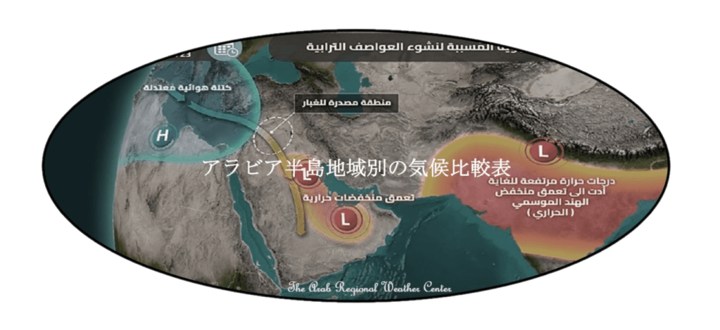
(3) アラビア半島南東部における対流性の降水
特にアラビア半島南東部はインド洋の一部であるアデン湾とバブエルマンデブ海峡に囲まれ大気は湿り気を含んでおり、この大気が熱せられると蒸発し、上向きの気流によって運れる水蒸気によって生み出される「対流性の雲」とよばれ、高くそびえる雄大積雲を作り出します。雄大積雲が発達して密集し、さらに高く垂直に近く聳えるのが積乱雲です。これらの対流雲は垂直方向と水平方向の範囲が限られているため、対流性降雨は比較的短時間で特定の領域に降ります。この降雨は、降り方が急速に変化する驟雨となって、比較的短時間しかに降りません。それでもこの対流雲の雨の恵みで、この地域にはある程度の降水量の齎らされます。ただ、雷や竜巻や雹石などを発生させる危険もあので注意も必要です。積乱雲がさらに発達すると、持続的に回転する上昇気流雨量を伴い、回転雷雨と呼ばれるスーパーセル(大竜巻雲」)の一種となります。中緯度地域では、対流性降水は寒冷前線に関連していることが多く、前線の後ろによく見られるため、線状降水帯の一種の陣風線が発生することがあります。
(3) Precipitation types in the southeastern Arabian Peninsula
In particular, the southeastern Arabian Peninsula is surrounded by the Gulf of Aden and the Bab-El-Mandeb strait, which are parts or contiguous zones of the Indian Ocean, and the atmosphere is moist. When this atmosphere is heated, it evaporates and is produced by water vapor carried by an upward convection. It is called a “convective cloud” and creates a towering cumulus congestus cloud.
It is the cumulonimbus cloud that has developed and densely crowded, and then rises higher and closer to the vertical. Due to the limited vertical and horizontal range of these convective clouds, convective rainfall falls on a particular area. This rainfall is a shower that changes rapidly, and it rains only for a relatively short time. Nevertheless, the blessings of this convective cloud rain bring some precipitation to the area. However, it is necessary to be careful because there is a danger of causing lightning, tornadoes, hailstones, etc.
As the cumulonimbus cloud develops further, it becomes a type of supercell, called a rotating thunderstorm, with a continuously rotating updraft. In mid-latitude regions, convective precipitation is often associated with cold fronts and is more common behind fronts. There is an opportunity to occur squall line (quasi-linear convective), which is a kind of “training (meteorology)” (“linear precipitation zone”).
(4) アラビア半島の地形的な特徴
この半島は、傾いた幅広の長方形で、海洋に突き出しているので、三方を海に囲まれています。西部の北から南までの海岸沿いにはサラワート山脈、南部も西から東までの海岸沿いにドファール山脈が連なっています。南東部にはオマーン湾沿いにハジャル山脈が聳えます。全体としてはサラワート山脈からアラビア湾に向けて緩やかに傾斜しています。地質的にはサラワート山脈に中央部分1/2を底辺とした丸みを帯びた台形状にアラビア楯状地が北東方面に突き出し、アラビア湾岸から石灰岩を主体とした堆積岩地帯がほぼ倍の広さでこの楯状地を包み込んでいます。その境付近にはこの楯状地に沿うようにトゥワイク山脈が延びています。この楯状地の北にはナフード沙漠が発達し、南と南東へ方面には空白地帯沙漠が広がっています、二つの沙漠はトゥワイク山脈両側に細く並ぶ、ダフナー沙漠とウルーク沙漠で結ばれています。
(4) Topographical features of the Arabian Peninsula
This peninsula is a tilted, wide rectangle that juts out into the ocean, so it is surrounded on three sides by the sea. The Sarawat Mountains are along the coast from the north to the south in the west, and the Dhofar Mountains are along the coast from the west to the east in the south. To the southeast, the Hajar Mountains tower along the Gulf of Oman. Overall, it slopes gently from the Sarawat Mountains towards the Arabian Gulf. Geologically, the Arabian Shield protrudes northeast into the Sarawat Mountains in a rounded trapezoidal shape with a base of 1/2 of the central part, and a sedimentary rock area mainly composed of limestone from the Arabian Gulf coast envelops this shield almost twice as wide. Near its border, the Tuwaiq Mountains extend along this shield. To the north of this shield is the An Nafud Desert, and to the south and southeast is the Rub’ al Khali Desert, the two deserts are connected by the Dahna Desert and the Uruq Desert, which are narrowly lined on both sides of the Tuwaiq Mountains.
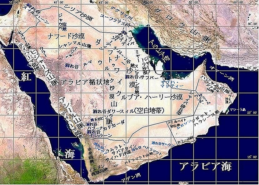
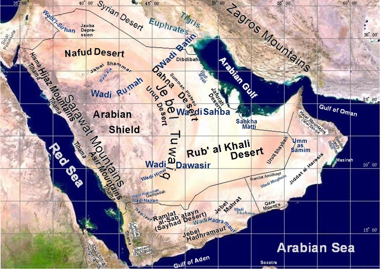
(5) What is the Asir Mountains?
サラワート山脈の内の北はバーハからアブハーを経由して南はザハラーン・ジャヌーブまでの山稜で、この地方と同じ名で呼ばれています。同じようにサウジアラビアではサラワート山脈の内のバーハから北の山稜は、その地方とやはり同じ名でヒジャーズ山脈と呼ばれています。
The Asir Mountains
The Asir Mountains is a part of the Sarawat Mountains. This ridge runs from Bahah in north to Dhahran Al Janoub in south via Abha. This ridge is called the same name as this region (Asir) in the Saudi Arabia. Similarly, the ridge north of Bahah in the Sarawat Mountains is called the Hijaz Mountains, as the manner as the region name.
(6) 降雨量低下と地球温暖化
年間降雨量が10年あたりおよそ50㎜減少している反面、シャマールやサイクロン等の嵐による洪水被害が増えています。また、地球温暖化で気温も10年あたりおよそ0.6℃上昇している一方で、降雪・氷結など低温被害も増えています。従って、これらの事象にも留意する必要があります。
(6) Decreased rainfall and global warming
While annual rainfall has decreased by about 50 mm per 10 years, the flood damages caused by storms, such as Shamals and Cyclones, are increasing. In addition, while the temperature has risen by about 0.6 ° C per 10 years due to the global warming, the low temperature damages such as snowfall and freezing are also increasing. Therefore, it is necessary to pay attention to these events as well.
(7) 総観気象
1,000km ~ 10,000km範囲の気象現象との定義なので、テレビ放送なので紹介される一般的な天気予報に必要になる気象現象と筆者は理解しています。なお、気象庁で気象予報に長年携われて来られた股野宏志博士は、日本気象学会発行の著作「総観気象学への招待」の中で次ように説明されています。
「天気図)は一定の時刻に各地で観測された風,気圧,気 温などの気象要素や天気を地図上に記入し,これらの分 布を世界共通の様式で表現したものである。天気図によ って広い範囲の気象状況を一望の下に見ることができ, また,一連の天気図によって広い範囲の気象状況の変化 や推移を知ることができる。天気図のことを総観図と呼 ぶことがある。天気図を舞台とした気象が対象であるから,天気図の上で、識別できないような小さい規模の現象は総観気象学の対象にはならない。天気図の上で識別されるような規模の現象を総観規模現象という。その具体的な代表例としては,日常的にもお馴染みになっている高気圧、低気圧、前線などがある。」
(7) Synoptic weather
Synoptic weather is defined as a meteorological phenomenon in the range of 1,000km to 10,000km. Therefore, it can be understood as a meteorological phenomenon required for weather forecasts generally reported on TV and radio.
Dr. Hiroshi Matano explains in his book “Invitation to the Synoptic Scale Meteorology”:
“A weather map shows meteorological elements such as wind, barometric pressure, and air temperature and the weather observed at certain times in various places, and expresses these distributions in a universal format. A wide range of weather conditions can be seen under a panoramic view from a weather map. And changes and transitions in a wide range of weather conditions can be known from a series of weather maps. The weather map is sometimes called the Synoptic scale weather map. Since the target is the weather set in the weather map, it is not a small-scale phenomenon that cannot be identified on the weather map. A phenomenon of a scale that can be identified on a weather map is called the Synoptic scale phenomenon. There are familiar high pressure (anticyclone), low pressure (cyclone), weather front, etc. “
Dr. Hiroshi Matano is a person who has been involved in weather forecasting for many years at The Japan Meteorological Agency. And this book is published by the Meteorological Society of Japan.
