
Chalcolithic Age, Bronze Age and Iron Age


目次(Index)
はじめに
Introduction
この時代(紀元前五千~一千年紀中頃)を通じて、残された遺跡にはジャウフ地方のラジャージル立ち石群や南ナフードの環状列石、ツムリ等の遺構や岩壁画があります。
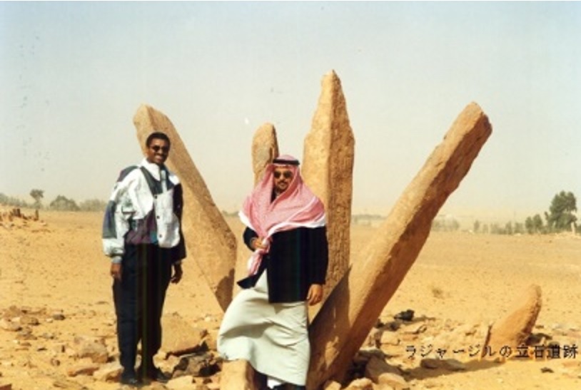
Throughout this period (5,000 to mid-1,000 BC), many archaeological ruins (remains or sites) and archaeological relics were left in a lot of places on the Arabian Peninsula. They include standing stones such as Rajaajil of the Jawf, stone circles such as one on the southern Nafud, and tumuli (cairn) and petroglyphs.
遺跡、岩壁画、碑文等
Relics, Petroglyphs, Inscriptions, etc.
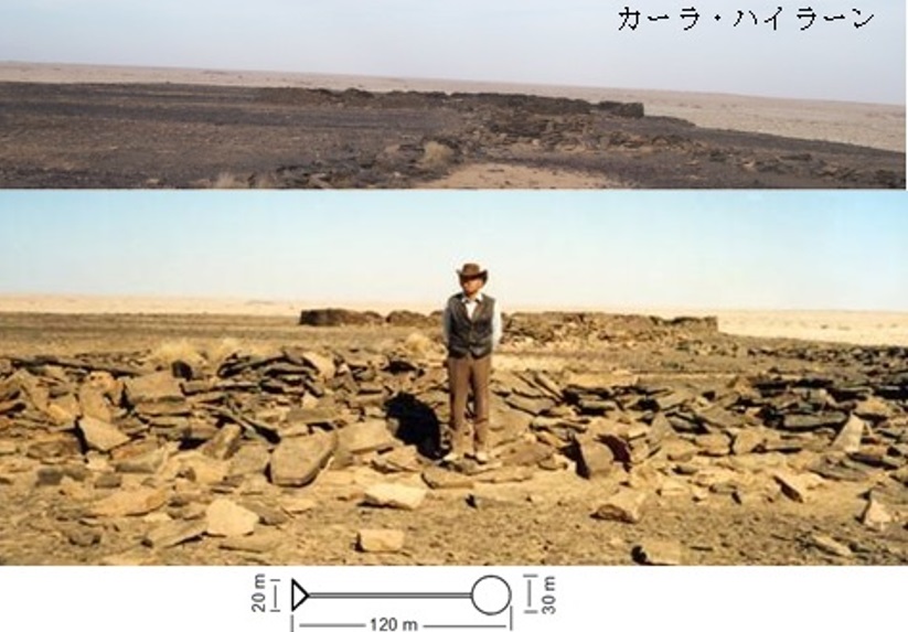
環状列石は涸れ谷アルアル、スィルハーン窪地、マハラ地方やズファール地方でも見られます。環状列石は太陽、星および月の観察に使われ、小高い岩山等の残るケルン状のツムリが墓ではないかと云われます。鉄器時代にはウラー北北東約100kmに位置し、平らな岩の台地上に建つカーラ・ハイラーンの様に前方後円墳を思わせる大型ツムリも現れました。又、巨大構築物はコール・ロフリ儀式場やミーダーマーン等があります
Stone Circles are also found in the Wadi Arar, the Sirhan Depression (Wadi’l-Sirhan), the Mahra (Yemen) and the Dhofar (Oman). A stone circle was used to observe the sun, stars, and moon, and it is said that a cairn-shaped tumulus remained on a small rocky mountain might be a grave. In the Iron Age, there were also large mounds reminiscent of the Japanese ancient keyhole-shaped burial mound, such as the Kala Hailan located about 100 km north-northeast of Al Ula and standing on a flat rock plateau. Giant structures are also found in the Khor Rohri Ritual Ground (the south-western Oman), the Midaman the southern Tihamah), etc.
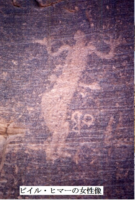
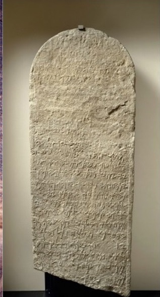
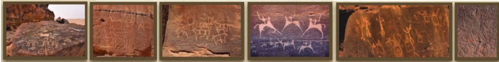
岩壁画や碑文はジャウバ窪地、ハーイル周辺(ジュッバ、ヤーティブ山、ミリーヒヤ、ジャナーン、サーフェン等)、ウラー渓谷やビイル・ヒマー等、古代の交易路や巡礼路に沿って各地で見られます。野生の猫、駱駝、駝鳥、獅子、馬、ガゼル、アンテロープや犬が描かれ、等身大の男や女の絵もあります。神々に供える儀式の様子や部族の領土を示すワスム等の記号も描かれてきました。碑文では紀元前6世紀のタイマー石柱が重要であるとされています。
Petroglyphs and inscriptions were found in various places along ancient trade and pilgrimage routes. Those places include the Jawba depression, the villages around Ha’il including Jubbah, Jabel Yatib, Milihiya, Jannan, Safen, etc., the Wadi Al Ula, the Bir Hima (the northern Najran) and other miscellaneous villages. Many animals were depicted on petroglyphs, such as sand cats, camels, ostriches, lions, horses, gazelles, antelopes, dogs, etc. There are also the petroglyphs that depicted life-size drawings of men and women. The symbols such as wasum, representing rituals offered to the gods and tribal territory, have also been depicted. Inscriptions, cut on the Tayma Stone during the 6th-century BC, are said to be important.
ハーイル周辺の碑文や岩壁画
ハーイルには多くの碑文や岩壁画を伴った先史時代や古代の遺跡があります。主な遺跡には、ジュッバー(Jubbah)、ミライヒア山(Milayhia mountain)、ヤティブ(Yatib)やジャンナイン(Jannain)等があります。岩壁画には、野生の猫、駱駝、駝鳥、獅子、馬、ガゼル、アンテロープや犬が描かれ、又、等身大の男や女の絵もあります。宗教的な画面は神々に供える様々な儀式の様子を示しています。岩壁にはその他にも部族の領土を示すワシム(Wasim)および太陽やその他の非宗教的な記号も描かれてきました。
ジュッバー(Jubbah)は、ハーイルの北西110 kmに位置し、旧石器時代中期、新石器時代、銅石時代、サムディック(Thamudic)時代そしてアラビア時代に渡り人々が住み、その遺跡が残されています。
ヤティブ山(Jabel Yatib)はハーイル東北東35 kmに位置し、様々な大きさのたくさんの石から成る砂岩の丘に紀元前500年頃にサムディク(Thamudic)碑文が二度にわたり刻まれました。
ミリヒヤ(Milihiya)は、ハーイル東南東40km、ヤティブ山(Jabel Yatib)の東南東5 kmに位置し、新石器時代初期、銅石時代、青銅時代および鉄器時代の遺跡が残っています。
ジャンアン(Jannan)は、ハーイルの東65 km、ミリヒヤ(Milihiya)の北東30 kmにある三つの砂岩の露頭で銅鉄時代および青銅時代の動物相が描かれ、鉄器時代とイスラム以前の碑文が刻まれています。
アルーサフェン(Al-Safen)はハーイル北西のジャバル・アジャー(Jibal Aja)の小さな涸れ谷(Wadi)に在り、ここの重要な遺構としては家畜の水飲みの為の溝や古代の掘り割りであり、その岩壁画から紀元前2,500年頃の遺構と思われます
Inscriptions and petroglyphs in the Hayil Emirate
Hayil has many prehistoric and ancient sites with plentiful inscriptions and petroglyphs. Major sites include Jubbah, Milayhia mountain, Yatib and Jannain. The petroglyphs depict wild cats, camels, ostriches, lions, horses, gazelles, antelopes and dogs, as well as life-size figures of men and women. Religious screens show various rituals offered to the gods. The rock walls have also been painted with wasims and suns to mark tribal territories, as well as other non-religious symbols.
Jubbah is located 110 km northwest of Hayil and was inhabited during the Middle Paleolithic, Neolithic, Chalcolithic, Thamudic and Arabian eras, and remains of their ruins.
Jabel Yatib is located 35 km east-northeast of Hayil, a sandstone hill composed of many stones of various sizes, twice inscribed with the Thamudic inscription around 500 BC.
Milihiya is located 40 km east-southeast of Hayil and 5 km east-southeast of Jabel Yatib, and contains remains from the Early Neolithic, Chalcolithic, Bronze and Iron Ages.
Jannan, 65 km east of Hayil and 30 km northeast of Milihiya, is a trio of sandstone outcrops depicting Chalcolithic and Bronze Age fauna and carved with Iron Age and pre-Islamic inscriptions. are rare.
Al-Safen lies in a small Wadi in Jibal Aja, northwest of Hayil, where important remains include watering ditches and ancient ditches for livestock. The petroglyphs are believed to date back to around 2,500 BC.
3,000~2,000年紀
3rd millennium to 2nd millennium
紀元前2450~1700年以降は、ディルムーンと呼ばれる文明がバハレイン島をその主な中心として栄えていましたが、半島本体ではその文明は、ハサーとヤブリーンで小さな遺跡が見つかったのみに留まっています。タールート島(カティーフ湾内)にあった繁栄する港がカティーフおよびハサー両方のオアシス農業の発展を促進させたと云う説は、ハサーの排水路に隣接した井戸や泉に近い低い土手から紀元前三千年紀の物と思われる陶器が見つかった事で裏付けられています。
After 2450 ~1700 BC, a civilization called the Dilmun flourished with the island of Bahrain as its main center, but as to the Arabian Peninsula itself, several small ruin were merely found only in Hasa and Yablin. There is the theory that the thriving port on the Tarut Island, located in the Bay of Khatif, facilitated the development of oasis agriculture in both Khatif oasis and Hassa oasis. This is evidenced by the discovery of potteries believed to be from the third millennium BC in a low bank adjacent to the drainage channel and near wells or springs in the both oases.
紀元前三千年紀以降、パレスタインからメソポタミアに至る地域を征服したアラビア土着民の幾つかは、マールツウ或いはアモリ人と呼ばれる粗暴でテントに住み、放牧をするセム語を話す民族でした。メソポタミア社会は紀元前三千年紀以降、急速にマールツウ族(アモリ人)を吸収同化しました。これらの高度に集権化された集落は、二千年紀には衰微し、アフラームー人等と呼ばれた遊牧民にナツメヤシを強奪され、集落も略奪を受けました。アフラームー人はアラム人の遊牧民であると確認はされていますが、アラム人は以前のアモリ人地域から政治勢力として出現した集団で、同じ民族が異なる名前で呼ばれたとの説やアラム人はアモリ人の子孫であるとの説があります。アフラームー人は駱駝遊牧民であり、二千年紀にはメソポタミア集落にとって大量の強奪を行う軍事的脅威となっていました。
After the third millennium BC, some of the indigenous peoples of Arabia who conquered the area from Palestine to Mesopotamia were a rough, tent-dwelling, grazing and Semitic-speaking people called the Mar Tu or Amorite. Mesopotamian society rapidly absorbed and assimilated the Mar Tu (Amorite) after the third millennium BC. These highly centralized settlements declined in the second millennium, when nomads known as the Akhlamu robbed them of their date farms and looted their villages. Although the Akhlamu had been confirmed to be Aramaean nomads, the Aramaean is a group that emerged as a political force from the former Amoritic region. There are theories that the same people were called by different names, and that the Aramaean was descendants of the Amorite. The Ahlam was a camel nomad, and by the 2nd millennium it was a military threat to the Mesopotamian settlements with massive robbery.
紀元前1200年頃から死海の南のネゲヴ沙漠やアラバ渓谷にセム語を話す部族が住んでおり、この地域に赤い砂岩が多いことからエドム人と呼ばれる様になりました。その後、この部族はペトラ付近に居住し、紀元前11~8世紀にはエドム人の国を築きました。このエドム人の国は、大いなる反乱と呼ばれる第一次ユダヤ・ローマ帝国戦争(66 – 73 AD)で終焉しています。
Since about 1200 BC, Semitic-speaking tribe had lived in the Negev desert and Arabah Valley south of the Dead Sea. And since there is a lot of red sandstone in this area, they had come to be called Edom. Later, this tribe settled near Petra, and in the 11th-8th centuries BC founded the country of the Edomite. This Edom nation ended with the First Jewish-Roman War (66–73 AD), known as “the Great Jewish Revolt” or “the Jewish War”.
1,000年紀
1st millennium
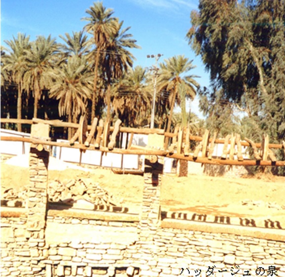
新アッシリア時代はメソポタミアの歴史では紀元前934~608年の間であり、その後も新バビロニアが紀元前539年にアケメネス朝キュロス2世に敗北するまで続ていました。古代には乳香の道の西ルートがビイル・ヒマーで分岐し、タスリース、ビーシャ、マディーナおよびタイマーを通って涸れ谷スィルハーンで東ルートと合流し地中海へと抜けていました。タイマーが最初にアッシリアの碑文に登場したのは紀元前8世紀でした。当時から豊かな水井戸ハッダージュ、それに支えられた農園、果樹園や優雅な建物で知られていました。ティグラト・ピレセル三世に朝貢して居り、センナケリブはタイマーをニネヴェの沙漠門と呼んでいました。タイマーの繁栄が頂点に達したのは紀元前555~539年のバビロニア王ナボニドゥス治世で、紀元前552年に同王はタイマーにアブラグと云う大きな城を築き、10年間も首都を置いていました。紀元267~272年にタドムル(パルミラ)を支配したアラブの女王で、父ザバーイから遊牧民アムラーキー族長を引き継いでいたゼノービヤーは、タイマーを襲撃した。防塞戦で撃退されて「アブラグ城は傲慢だ」とゼノービヤーが罵った程、タイマーは力を持っていました。このオアシスには先史時代からイスラーム時代までの考古学的遺跡があり、更に紀元前6世紀に遡る古代の碑文やイスラーム初期の遺跡も存在しています。
The Neo-Assyrian Empire in Mesopotamian history was between 934 (911) and 608 B.C, after which Neo-Babylonian Empire (626~ 539BC) was established. Neo-Babylonian Empire lasted until it was defeated by the Achaemenid Cyrus 2 in 539BC. In ancient times, the western route of the Frankincense Road branched off at Bir Hima and passed through Tathlith, Bishah, Madina and Tayma to join the eastern route at Wadi’l-Sirhan and pass through the Mediterranean. Tayma first appeared in Assyrian inscriptions in the 8th century BC. From that time Tayma was known for its rich water well Haddaj, the plantations supported by it, orchards and elegant buildings. Tayma paid tribute to Tigrat Pileser III, who called the Tayma the desert gate of Nineveh. Tayma ‘s prosperity reached its zenith during the reign of the Neo-Babylonian King Nabonidus (556–539 BC), and in 552 BC Nabonidus built a large castle in Tayma called Ablaq, where he held the capital for 10 years. Zenobia, the Arab queen who ruled Tadmor (Palmyra) in 267-272 AD and had inherited the nomadic Amlaqi chieftain from her father Zabbai (Amr ibn al-Ẓarib), attacked the Tayma. The Tayma was so powerful that it was repelled in the blockade and Zenobia cursed that ” Ablaq Castle is arrogant.” This old oasis is home to archaeological sites dating from prehistoric times to Islamic times, as well as ancient inscriptions dating back to the 6th century BC and early Islamic sites.
紀元前9~6世紀に掛けての北アラビア戦役についてアッシリアやバビロニアの碑文には「アルブは部族的に組織され駱駝に騎乗し、半島北部および北西部のアドゥーマートゥー、タイマー、ディーダーン(ウラー)等の主要なオアシス集落を結んで交易を行う民族である」と記されています。アルブは戦場に大勢の駱駝騎乗戦士を送り込む能力だけではなく、交易に従事し、紀元前6世紀までに北西部のタイマーやディーダーン等が隊商町として十分に機能が確立していました。これは、半島南西部から現在のレバノンであるレヴァント(地中海東部沿岸)へ物資を輸送する為の交易上の重要な役割を担っていた事を示しています。
Assyrian and Babylonian inscriptions about the Northern Arabian campaign of the 9th-6th century BC state that “Arubu (عرب) was tribally organized and mounted on camels. They ethnically engaged in the trade business connecting the major oasis settlements such as Adummat, Tayma and Dedan.” Arubu was not only capable of sending large numbers of camel-mounted warriors to a battlefield, but also engaged in trade as mentioned above. And by the 6th century BC, the Tayma, Dedan, and others in the northwestern peninsula had been well established as caravan towns. This indicates that it played an important role in trade in transporting goods from the southwestern peninsula to the Levant (eastern Mediterranean coast) in present-day Lebanon.
紀元前8~7世紀にかけてアラビア半島北部の主要なアラブ居住地であったドゥーマ・ジャンダルにはアドゥーマートゥーと云う名の王国がアッシリア年代記に記録されています。また、紀元前6世紀頃からは半島北西部にはリフヤーンと云う王国がありました。
In the 8th and 7th centuries BC, Dumat al-Jandal, a major Arab settlement in the northern peninsula, was recorded the kingdom named Adummatu (Adumatu) in the Assyrian Chronicles. Also, from around the 6th century BC, there was a kingdom called Lihyan in the northwestern peninsula.
