6.2 Winds blowing on Arabian Peninsula

目次
Contents
季節風
Monsoon
| アラビア半島における主たる風の発生は、季節風に起因しています。 | Wind sources on Arabian Peninsula are mainly monsoon. |
| 季節風は、「陸風・海風すなわち陸は温まり易く冷め易い、その一方で海は温まり難く冷めにくい」ので夏には陸が暖められるので風は海から陸へ、冬には海が暖かいので陸から海へと流れる風で、モンスーンと呼ばれています。 | Its principle is based on land breeze and sea breeze: land warms and cools easily, while sea changes temperature slowly. In summer, land becomes hot, so wind flows from sea to land. In contrast, in winter, sea stays warm longer, so wind flows from land to sea. |
| 因みにモンスーンの語源は、アラビア語の季節マウスィム(موسم)だと言われています。 | This word “monsoon” is said to come from Arabic “mawsim” (موسم), meaning “season”. |
貿易風
Trade Winds (Easterlies)
| これに次ぐのが地球規模で起きる風の循環です。 | Next effective wind system after monsoon is global wind cycle. |
| アラビア半島の付け根部分が、貿易風と偏西風が分岐する「馬の緯度」に当たるので、アラビア半島は貿易風地帯にあります。 | Root zone of Arabian Peninsula belongs to “horse latitudes,” where trade winds (easterlies) and westerlies (anti-trades) branch off. |
| 大まかには季節風が卓越しますが、風は常に貿易風によって北東から南西へと押されています。 | As such, this peninsula lies within trade winds (easterlies) zone. Roughly, monsoons dominate, but winds are consistently pushed from northeast to southwest by trade winds (easterlies). |
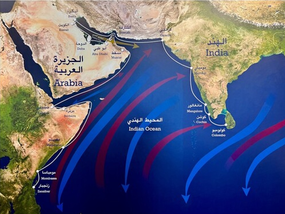
| 西インド洋の貿易風:南西モンスーン=赤い上向き矢印;北西モンスーン=青い下向き矢印; シャマール(شمال)=黄色の右向き矢印。白線は沿岸航路を示しています。 | Trade winds of western Indian Ocean: southwest monsoon = red upward arrows; northwest monsoon = blue downward arrows; shamal (شمال) = yellow rightwards arrow. White lines show the coastal sailing routes. |
| 帆船時代にはインドへ向かう湾岸のドウ船には2つの航海シーズンがありました。 | Gulf dhows heading to India had two sailing seasons during sail era. |
| 南西モンスーン(أول الكوس)の始まりは3月中旬から5月中旬にかけて、南西モンスーン(آخر الكوس)の終わりは8月中旬から9月下旬から10月初旬にかけての期間です。 | Southwest monsoon (أول الكوس) starts between mid-March and mid-May, while southwest monsoon (آخر الكوس) ends between mid-August and late September or early October. |
| インドの港は、南西モンスーンの最盛期(5月下旬から8月中旬)に、インドの豪雨と強風のため航行が閉鎖されました。 | India’s ports were closed to shipping during height of southwest monsoon (late May to mid-August) due to heavy rains and strong winds in India. |
| 10月初旬から3月中旬までの北東モンスーン全体は、インドからアラビア湾へ西行きのダウ船にとって良好な時期でした。 | Entire northeast monsoon from early October to mid-March was good for westbound dhows sailing from India to Arabian Gulf. |
Cultural Cousins: Indo-Gulf Connections since Antiquity (2025), by James Onley
偏西風
Westerlies (Anti-trades)
| 偏西風については、アラビア半島は、その領域にはないのですが、ヨーロッパ・アルプスの影響を受け、地中海を通じてアラビア半島に渡ってくる風があります。 | As for westerlies (anti-trades), Arabian Peninsula is not in that zone. However, under influence of European Alps, winds travel through Mediterranean toward Arabian Peninsula. |
| その風が「アラビア湾に向かって移動し、ルブア・ハーリー沙漠を通って南と南西に向きが変わる」とされています。 | These winds are said to “move toward Arabian Gulf and swing south and southwest through Rub’ al Khali desert.” |
アラビア湾岸の風
Winds along Arabian Gulf Coast
| 一般的にアラビア半島全体での卓越風向は西から北西ですが、地域によって多少異なっています。 | Generally, prevailing wind direction across Arabian Peninsula is from west to northwest, though it varies slightly by region. |
| アラビア湾側では乾いたシャマール(شمال north)と呼ばれる北西からの北風が夏の卓越風向であり、5月から吹き始めて、7月上旬に最大になります。 | On Arabian Gulf side, dry northwesterly wind called Shamal (شمال, meaning “north”) is predominant summer wind, starting in May and peaking in early July. |
| シャマールの風が時速40〜50キロ(最大100キロ)の速度で数週間吹き続けることもあり、クウェイトからアラブ首長国連邦にかけてのアラビア湾沿岸地帯に沙嵐を巻き起こします。 | Shamal can blow at speeds of 40–50 km/h (up to 100 km/h) for weeks, causing sandstorms in littoral zone of Arabian Gulf, stretching from Kuwait to United Arab Emirates. |
| 日中は沙嵐を発生させますが、夜には風も落ち着きます。また、ダンマームを過ぎて南のルブア・ハーリー沙漠に入ると風域も広がり、勢いも落ちて砂を広く堆積させます。 | Sandstorms occur during day, but winds calm down at night. After passing Dammam and entering Rub’al Khali in south, wind zone expands, momentum drops, and sand accumulates widely. |
| このシャマールも7月には吹き止み、風の穏やかな8月となります。夏のもう一つ卓越風は、サムーム(シムーン)(سموم)(毒素)と呼ばれる南から吹く風で、熱くて完全に乾燥しています。 | Shamal also stops blowing in July, followed by August when winds are calm. Another prevailing wind in summer is southerly wind called Simoom (سموم, meaning “toxins”), which is hot and completely dry. |
| 9月からは地中海の低気圧が東へと相次いで通過し、北アラビアから南はラアス・タヌーラ付近まで勢力を張るようになります。10月、11月は涼しい気候への変わり目で、アラビアでの秋と言えます。 | From September, cyclone (low-pressure system) coming from Mediterranean passes eastward one after another. From northern Arabia to its south, these systems spread toward vicinity of Ras Tanura. October and November mark transition to cooler climate and can be considered fall in Arabia. |
| 風向きは変化を増し、雨が11月から4月まで時折降り、そのピークは12月、1月です。 | Wind direction changes, with occasional rains from November to April, peaking in December and January. |
| その2か月がアラビアの冬で地域的な嵐や強風が吹くことも少なく無くありません。日中でも寒いことが多い時期です。 | These two months are winter in Arabian Peninsula, with many regional storms and strong winds. It is often cold even during day. |
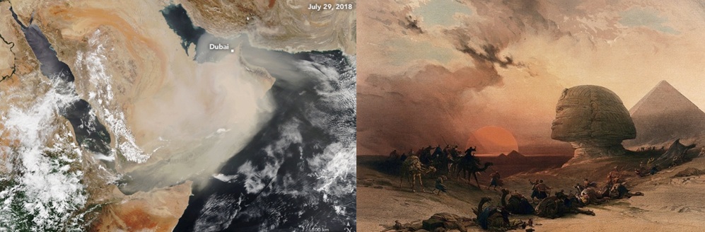
| Sandy Shamal Season (2018., Nasa) | Simoom in Desert of Gizeh, Egypt (Wikipedia) |
内陸地方の風
Inland Winds across Arabian Peninsula
| 内陸部、とくに北西のジャウフ州では、風が気候の際立った特徴となっています。 | In Jawf province of northwestern region, wind is a notable feature of climate. In winter, many winds blow from east. |
| 冬には東からの風が多く、特に南部では北東から南西へ向かう典型的な冬の風(冬のシャマール)が吹きます。 | Especially in southern part, typical winter wind called winter Shamal blows from northeast to southwest. |
| 春には、タブーク州を含む地域で西からの風が多くなります。これらの風はトゥワイク山脈に沿って弧を描きながら南下し、ルブア・ハーリー砂漠に入るとさらに西南西へと向きを変えます。 | Spring is season when winds from west become common, especially in parts of Jawf and Tabuk provinces. These winds arc south along Jebel Tuwaiq and turn west-southwest after entering Rub’ al Khali. |
| この風の流れは、トゥワイク山脈、タウロス山脈、ザグロス山脈、ハジャル山脈に囲まれた空域において、北東から吹く貿易風の影響によるものと考えられます。 | This pattern seems caused by trade winds (easterlies) blowing from northeast in airspace surrounded by Jebel Tuwaiq, Taurus Mountains, Zagros Mountains, and Hajar Mountains. |
| 夏には、北西部は非常に暑く乾燥しますが、冬になると南東からの風が雨をもたらします。 | When winter arrives in this hot and dry northwestern region after summer, wind from southeast brings rain. |
| これに対して、北や西から吹く風は一般的に冷たく厳しいものです。この北や西からの風がナジュド地方のリヤードに到達する頃には、ほとんどの水分が失われており、降雨をもたらすことはほとんどありません。 | In contrast, winds from north and west are usually harsh and cold. By time these winds reach Riyadh in Najd region, most moisture has been lost. Therefore, winds from north and west rarely bring rain to Riyadh. |
| ナジュド地方では、夏に「サムーム(سموم:毒素)」と呼ばれる南からの卓越風が吹きます。この風は非常に熱く、完全に乾燥しています。 | In summer, prevailing wind called Simoom (سموم, toxins) blows from south in Najd. Climate is hot and completely dry. |
| 冬には、同じく「シャマール(شمال:北)」と呼ばれる冷たく乾いた風が、遠く中央アジアから吹いてきます。 | In winter, cold and dry wind called Shamal (شمال, north), same name as in summer, blows from far north, such as central Asia. |
| シャマールは冬の終わりになると、地中海東部から進んでくる低気圧によって遮られます。この低気圧の風がナジュドにわずかな雨をもたらし、砂漠の植生をよみがえらせる貴重な春の雨となります。 | At end of winter, cyclone from eastern Mediterranean blocks Shamal. Wind from cyclone brings little rain to Najd region. Even if small, this rain is most precious in spring, helping revive desert vegetation. |
| 紅海側の内陸部では、冬に紅海を通って雨を運ぶ北西風が吹きます。南へ下ると、夏には南からモンスーンが吹き、豊かな雨をもたらします。 | On Red Sea side, northwesterly wind blows inland in winter and brings rain. Further south, monsoon from south blows in summer and brings abundant rain. |
| そのため、北部では冬に降雨が集中するのに対し、アシール南部などでは年間降雨量の約80%が夏に集中しています。 | While northern region receives rain mainly in winter, about 80% of rainfall comes in summer in southern part of Asir region and nearby areas. |
南東部キダン地方の風
Winds in Kidan Area, Southeastern Arabian Peninsula
| アシール地方(عسير)とは対照的にルブア・ハーリー沙漠(الربع الخالي)を挟んで、その東に位置し、アブダビ国境南でオマーン国境西に近いキダン(كــد ن)を中心とした地方があります。 | There is a region centered on Kidan (كــد ن), located south of Abu Dhabi border and near western edge of Oman border. Kidan area lies east of Rub’al Khali (الربع الخالي) desert, in contrast to Asir region (عسير). |
| そこでの天然ガス開発のために行われた風向調査では、この地域の風の59%が北の角度(北東、北、北西)から来ていることが示されました。 | A wind direction survey was conducted in connection with natural gas development in this area. Survey showed that 59% of winds come from northern angles — northeast, north, and northwest. |
| これは基本的にシャマール(الشمال)(夏と冬の両方で発生)であり、時にはハブーブ(الـهـبوب)と呼ばれることもあります。 | These winds are basically known as ‘shamal (الشمال)’ (occurring in both summer and winter), and sometimes locally referred to as ‘haboob (الـهـبوب)’. |
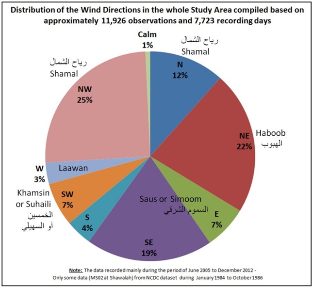
| ルブア・ハーリーにおける風の方向を研究するための 空間技術の使用 | Use of Spatial Technologies to Study Winds’ Directions in Rub’ Al-Khali, Desert, Saudi Arabia |
| Earth Science and Engineering 5(2015)372-381 | Journal of Earth Science and Engineering 5 (2015) 372–381) |
| アリー・マダン・アール=アリー(عَلِي مَدَن آل عَلِي) | Ali Madan Al-Ali (عَلِي مَدَن آل عَلِي) |
| ソース(صوص)またはサムーム(السموم الشرقية)と呼ばれる風は、2番目に多く(26%)、東および南東方向から来ていました。 | Eastern winds, called ‘saus (صوص)’ or ‘simoom (السموم الشرقية)’, were second most frequent (26%), coming from east and southeast directions. |
| 南風としては、南西からのハムシーン(الخمسين)またはスハイリ(السهيلي)(7%)が記録されています。 | A southerly wind, recorded at 7%, coming from southwest, is referred to as ‘khamasin (الخمسين)’ or ‘suhaili (السهيلي)’. |
| なお、ワーディ―・ダワーシル(وادي الدواسر)ではこの風を「南風」と呼び、その中心都市もハマーシーン(الخماسين)と呼ばれています | In Wadi Dawasir (وادي الدواسر), this wind is called “south wind,” and central city is also named Khamasin (الخماسين). |
南部アデン湾・アラビア海の風
Winds along Littoral Zones of Gulf of Aden and Arabian Sea Coast
| アラビア半島南部のアデン湾(خليج عدن)やアラビア海(بحر العرب)の沿岸では、冬季に北東から南西へ吹く季節風が見られます。 | Along littoral zones of Gulf of Aden (خليج عدن) and Arabian Sea (بحر العرب), winter monsoon blows from northeast to southwest. |
| 夏季には、湿度の高い南西モンスーン(موسم)が吹き、時に強風を伴います。 | During summer season, humid southwest monsoon (mawsim (موسم), meaning ‘season’) blows, sometimes accompanied by strong winds. |
| この強風はカーリフ(خارف)と呼ばれ、ルブア・ハーリー沙漠(الربع الخالي)の南端まで広がり、ピラミッド型や線形の砂丘群の形成に寄与しています。 | This strong wind, called kharif (خارف), reaches southern edge of Rub’ al Khali Desert (الربع الخالي) and helps form a series of pyramidal and linear dunes. |
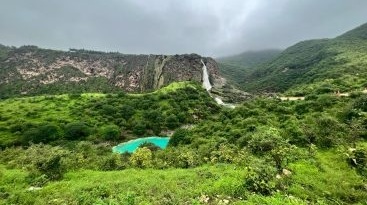
| カーリフの季節のサラーラ(صلالة) | Salalah (صلالة) during Kharif Season |
紅海岸ティハーマ地方の風
Winds in Tihama Region, Red Sea Coast
| 紅海沿岸のティハーマ地方(تهامة)では、小規模な風成砂丘を除き、風による砂丘形成への関与は限定的です。しかし、紅海(البحر الأحمر)に吹く風の特徴について記述しておきます。 | Tihamah region (تهامة), located along Red Sea coast (البحر الأحمر), plays only a limited role in shaping aeolian dunes, except for small-scale formations. Due to unique wind conditions in this zone, wind patterns over Red Sea deserve attention. |
| 紅海は、大地溝帯(الوادي المتصدع الكبير)の一部であり、両岸を高い尾根に挟まれた、長さ2,300 kmに及ぶ細長い盆地状の海域です。しかし、幅は最大でも355 kmに過ぎません。 | Red Sea, part of Great Rift Valley (الوادي المتصدع الكبير), forms a 2,300-kilometer-long elongated basin flanked by high ridges. Width reaches no more than 355 kilometers even at widest point. |
| この海域は、亜熱帯乾燥地帯に位置し、サハラ砂漠(الصحراء الكبرى)およびアラビア半島の二大砂漠に囲まれているため、年間蒸発量は2 mを超えます。 | Surrounded by Sahara Desert (الصحراء الكبرى) and Arabian Peninsula, both situated in subtropical arid zone, this sea experiences annual evaporation exceeding 2 meters. |
| この補充は唯一の外洋との接続水路である南端のバブエルマンデブ海峡(باب المندب)から流入で供給されます。 | Water inflow is sustained solely through Bab-el-Mandeb Strait (باب المندب) at southern end. |
| このような地形的特徴により紅海に吹く風は、アラビア半島に吹く風とは、その影響は、受けるものの異なっています。 | Due to this distinctive terrain, winds over Red Sea behave differently from those blowing across Arabian Peninsula. |
| 2017年5月12日付のキング・アブドゥッラー科学技術大学(KAUST)の報告によると「紅海に吹く風は次の4種類がある」とされています: | According to report issued by King Abdullah University of Science and Technology (KAUST) dated May 12, 2017, four types of winds are observed over Red Sea: |
| (1)地中海から紅海に北西風が吹きこんできます。夏季にはエーゲ海沿岸地域で発生する乾燥した強い北風のエテジアン風(إيتزية رياح)によって強められる上に、紅海では5月から10月までの夏の間は、南東風の吹かないので、この北西風が、紅海での卓越風向となります。特に、地中海の嵐が通過した後など、強い北西風がシナイ半島(شبه جزيرة سيناء)の西側を通り抜け、南向きに吹き、時には紅海の南端に達することもあります。 | (1) Northwesterly wind from Mediterranean Sea enters Red Sea. During summer, this flow is intensified by dry and strong northerly etesian wind (إيتزية رياح) originating along Aegean coast. Since southeasterly winds do not blow in Red Sea from May to October, northwesterly wind becomes dominant. Especially after Mediterranean storms, strong northwesterlies pass west of Sinai Peninsula (شبه جزيرة سيناء), blowing southward and sometimes reaching southern tip of Red Sea. |
| (2)11月から4月までの冬の間にアラビア半島に吹くシャマール(الشمال)(北東の季節風)は、サラワート山脈(جبال السروات)南部の2,000~3,000 mの山嶺およびエチオピア高原(مرتفعات إثيوبيا)の1,500~4,000 mの山々に阻まれて、アデン湾(خليج عدن)で風向がそらされ、紅海をその軸に沿って北西に進む南東風に変えられます。この南東風が流域南部で強く、北向きに次第に弱くなりますが、紅海の中ほどでは 地中海からの北西風に対抗でき、紅海収束帯を作り出します。 | (2) Shamal (الشمال), a northeast monsoon blowing across Arabian Peninsula from November to April, is blocked by 2,000–3,000-meter ridges in southern Sarawat Mountains and 1,500–4,000-meter peaks in Ethiopian Highlands. Wind direction is diverted over Gulf of Aden (خليج عدن), transforming into southeasterly flow that travels northwest along Red Sea axis. This wind is strongest in southern basin and gradually weakens northward. In central Red Sea, it can counter northwesterly flow from Mediterranean, forming a convergence zone. |
| (3)アフリカ側では、クンフザ(قنفذة)のほぼ対岸に位置するトカル山峡(طوكر)に6月から9月にかけて、夏の間は、毎日、総観規模の風力発生機構によって西風が吹きつけます。この風は、狭い地峡(برزخ)に集まることでジェット化され、さらに、紅海岸での海陸風発生や滑降風(رياح سفحية هابطة)効果によって加速されます。これらのトカル山峡風は東向きに吹き、しばしば沙嵐を伴います。一般的に紅海の盆地状地形のために南部へと向きを変えます。 | (3) On African side, westerly wind blows daily from June to September through Tokar Gap (طوكر), located opposite Qunfudhah (قنفذة). Driven by synoptic-scale wind system, this flow is funneled through narrow isthmus (برزخ), forming a jet stream. Acceleration is enhanced by coastal sea breeze and katabatic wind (رياح سفحية هابطة) effects. Tokar Gap wind blows eastward, often accompanied by dust storms, and generally veers southward due to basin-shaped terrain of Red Sea. |
| (4)紅海北部ではアラビア半島の冬場の季節風(北東シャマール)は、サラワート山脈に阻まれています。しかし、時折、サラワート山脈北部の山峡(برزخ)から強い集中ジェットが紅海に吹き込み、北部地域に局所的に影響を及ぼします。 | (4) In northern Red Sea, northeast Shamal is usually blocked by Sarawat Mountains. Occasionally, however, strong jet flows emerge from narrow isthmus (برزخ) in northern Sarawat range, producing localized wind effects along northern coast. |
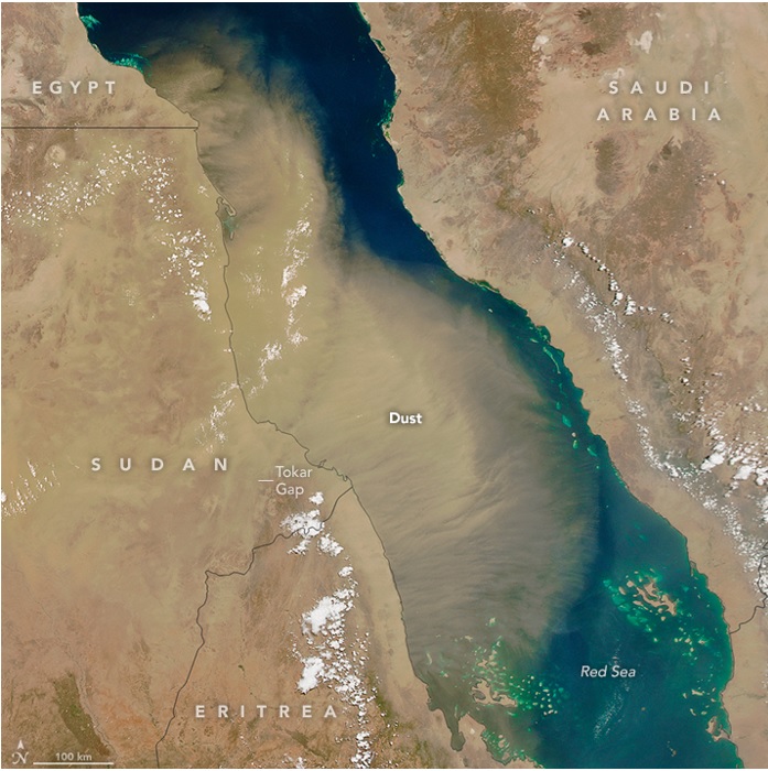
| トカル山峡から吹き出す沙塵 (2016年6月15日NASA提供) | Dust blowing from Tokar Gap, presented by NASA on June 15, 2016 |

