
6 Factors that increase the wind power
of the sand dust storm


目次 (Index)
6.1 超熱帯の上層階の気圧の谷の浸透
6.2 東西圧力勾配の増大
6.3 大気の不安定性に起因する多くの外部気象要因の影響
6.4 世界規模の大型沙嵐の発生
6.5 ハブーブ
6.1 Penetration of troughs on the upper floors of the ultratropics
6.2 Increasing east-west pressure gradient
6.3 Effects of many external weather factors due to atmospheric instability
6.4 Outbreak of large-scale dust storm on a global scale
6.5 Haboob
6.1 超熱帯の上層階の気圧の谷の浸透
激しい沙嵐は、冬と春の総観スケール駆動の前線システムと夏と秋の間に対流システム(降水セル(積乱雲)の複合体)によって支配され、年間を通じて発生します。春には沙嵐の頻度がピークに達し、表面近くの寒冷前線に関連する超熱帯の上層階の気圧の谷が定期的に半島に浸透します。
6.1 Penetration of troughs on the upper floors of the ultratropics
Severe sand dust storms occur throughout the year, dominated by a synoptic scale-driven front-line system in winter and spring and a convection system (a complex of precipitation cells (cumulonimbus clouds)) between summer and autumn. In the spring, the frequency of sand dust storms reaches its peak, and extra-tropical upper-level troughs associated with cold fronts near the surface regularly seep into this Peninsula.
6.2 東西圧力勾配の増大
シャマールによる沙嵐は、東西(ザグロス山脈とナジュド高原の間)での圧力勾配が大きく成ると、半島中央部での発生も増え、勢力も増大します。
6.2 Increasing east-west pressure gradient
Shamal sand dust storms are more frequent and more powerful in the Central Arabian Peninsula as pressure gradients increase in the east and west (between the Zagros Mountains and the Najd Plateau).
6.3 大気の不安定性に起因する多くの外部気象要因の影響
沙嵐は、大気の不安定性に起因するくぼみや気流である多くの外部気象要因の影響を受けて勢力を増します。例えば、「一般的に、低気圧の接近や寒冷前線の通過による風の強まり、とくに春には砂嵐の頻度がピークに達し、表面近くの寒冷前線に関連する超熱帯の上層階のトラフが定期的にアラビア半島に浸透します。」、一日で言えば「砂嵐活動のピークは、通常、地面の激しい太陽熱が乱気流と局所的な圧力勾配を発生させる昼間に起こります。」また、「日の出で毎日太陽熱が始まった後、夜行性の低レベルジェット(LLJ)からの高運動量が激しい乱流混合によって下向きに混合するため、朝の時間帯にダスト活動のピークなる」こともあります。
6.3 Effects of many external weather factors due to atmospheric instability
Sand dust storms gain power under the influence of many external meteorological factors, such as depressions and air currents due to atmospheric instability.
For example, there are the following factors.
- In general, the frequency of sand dust storms peaks, especially in the spring, when the wind is intensified due to the approach of a low pressure system and the passage of a cold front.
- Extra-tropical upper-level troughs associated with cold fronts near the surface regularly infiltrate the Arabian Peninsula.
- During 24 hours, the peak of sand dust storms activity usually occurs during the day when intense solar heat on the ground creates eddy and local pressure gradients.
- After the daily solar heat begins at sunrise, the high momentum from the nocturnal low-level jet mixes downwards due to intense turbulent mixing, resulting in peak dust activity during the morning hours.
6.4 世界規模の大型沙嵐の発生
上記の増幅された東西の圧力勾配がシャマールを急増させ、この半島に最初の激しい沙嵐を生じさせます。この北風の激しい沙嵐にルブア・ハーリー沙漠南東部では偏西風のソマリアジェットが合流すると、二つの風が互いに作用し合い収束します。その過程で、北風の激しい沙嵐に運ばれてきた砂塵は、停滞し蓄積します。この砂塵が、長波放射(地球の大気や地表面が発する熱放射)の増加によって夜間でも地表の温度上昇を招き、アラビア湾およびアラビア海からこの沙漠への海上気団の流入を起こします。この収束によって停滞している砂塵は、さらに長波放射を増加させ、陸側を温めます。海との間の温度勾配が高まり、海上気団の流入を急増させます。陸地の乾燥した熱い暖気と海からの湿った比較的冷たい海上気団の傾圧が生じます。収束帯ではこの傾圧によって上昇気流を起こす前線形成を増加させ、低気圧の発生をもたらします。ルブア・ハーリー沙漠南東部での低気圧形成は、一層激しい第二次的な沙嵐を引き起こします。2018年7月末に第二次的な激しい沙嵐の典型的な例が出現しました。高度5,000メートルまで砂塵を舞い上げて運び、地球上の主要なダスト源を生み出させる大型の沙嵐を生み出しています。また、海上気団の流入による水分の増加は低気圧をさらに強めて、ダストエアロゾルとしての砂塵の放出と湿った空気団を流入を促進しました。湿った空気団の上昇気流中で、ダストエアゾルが雲凝結核として作用して局地的な雨を降らせています。シャマールによる激しい沙嵐が、ソマリアジェットと合流することに加えて、砂塵の長波放射による温度上昇が、沙嵐を増大させる大きな要因として見直されています。
(偏西風のソマリアジェット:南西モンスーは、赤道を横切るときに北にそらされ、アフリカの山々によってさらに東にそらされます。ケニア、ソマリア、サヘルを通過し、アフリカ沿岸を低レベルで非常に速いジェット気流となってインドに向かいます。この低レベルジェットの大部分は5月に東アフリカに浸透し、その後、6月にインドに到達する前にアラビア海の北部を横断します。ソマリアジェットは、これら低レベルで非常に速いジェット気流の一つです。)
6.4 Outbreak of large-scale dust storm on a global scale
The amplified east-west pressure gradient described above causes shamal to surge and give rise to the first violent sand dust storm on this Peninsula. When this northerly sand dust storm is joined by the Somali Jet Stream blowing from west in the southeast part of the Rub’ al Khali Desert, the two winds interact with each other and converge together.
A lot of dust is carried by the fierce Sand dust storm of the north wind. This dust stagnates and accumulates, in this process. This dust causes an increase in long-wave thermal radiation, which emitted by the Earth’s atmosphere and surface, to cause for temperatures on the Earth’s surface to rise even at night. Then, it causes the influx of air masses from the Arabian Gulf and Arabian Sea into this desert.
The dust that is stagnant due to this convergence further increases the long-wave thermal radiation and warms the land side. In this way, the temperature gradient between the sea side and the land side increases, and the maritime air mass rapidly flows inland. It causes the baroclinity between “the dry hot warm air mass of the land” and “the moist and relatively cold maritime air mass of the sea”. In the convergence zone, this baroclinity increases the formation of fronts that cause updrafts, resulting in the generation of cyclones.
The formation of a low-pressure system in the southeastern Rub’ al Khali Desert will trigger a second and more intense sand dust storm. A typical example of the second violent sand dust storm emerged at the end of July 2018. It soars and carries dust up to an altitude of 5,000 meters, creating a large sand dust storm that creates a major source of dust on Earth.
Also, when the maritime air mass flows in, the moisture in the air increases. It further fortifies the cyclone, promoting the release of dust as a dust aerosol and the influx of moist air clusters. In the updraft of moist air clusters, dust aerosols acted as cloud condensation nuclei, causing localized rainfall.
Once the violent sand dust storm of shamal merges with the Somali jet, the dust causes to rise the air temperature due to the long-wave thermal radiation. It has been reviewed as one of the major factors intensifying sand dust storms.
(: Somali Jet is derived from westerlies. The southwestern Monsoon is deflected to north as it crosses the equator. It is then distracted to east by the topographical features of the African mountains. Passing through Kenya, Somalia and Sahel, it is created a low-level, very fast jet stream along the African coast. Then this jet stream heads for India. Most of this low-level jet penetrates through the east Africa in May and then crosses the northern Arabian Sea before reaching India in June. Somali Jet is one of these low level and very fast jet streams.)
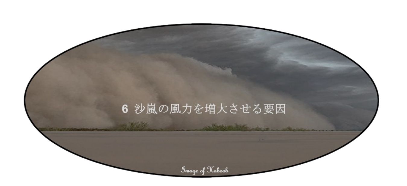
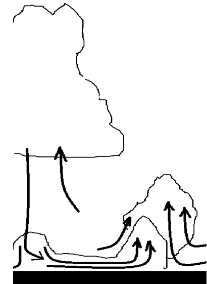
6.5 ハブーブ
地形やその他の地域的な理由で、大気中に暖かい空気が下になり、冷たい空気が上になるような不安定な状態が表れることがあります。そのような場合は、地上の暖かい空気が砂や砂塵を浮遊させた状態で、周囲の空気を集めて上昇気流を作り出します(雷雲(thunderstorm)の形成)。
上昇した沙漠の空気は、上空では周囲から冷やされているので、含まれる僅かな水分も氷滴となって、積乱雲を作ります。上昇気流が止み減衰期に入ると、氷滴は空気より重いので、地上に落ち始めます。ただし、下から続いて上昇してくる沙漠の暑い空気で氷滴は融解され、蒸発するので、地上まで落ちることは殆どありません。この過程で氷滴は、周囲の空気から潜熱を引き出してり冷却し冷たい空気を生み出します。同時に電位の違いによって雷も発生します。この状態は尾流雲とも呼ばれ、冷たい空気は周囲の暖かい空気よりも密度が高いため、下降気流となって、暖かい空気との境界に沿って、地上まで一気に滑り落ちる様に流出します。地上に衝突すると、水平に吹き出し、地表に沿って周囲に広がり、暖かい空気とぶつかる境界に上昇気流を起こして、砂と砂塵の壁を作り出します。これがダウンドラフトです。暖かい空気の下に入り込む様に広がるので重力流侵入と表現されることもあります。この上昇気流の壁は、突風前線と呼ばれています。このダウンドラフトのうち、地上に災害を起こすほど極端に強いものがダウンバーストです。
尾流雲の規模が大きいと砂塵に混ざって地上まで氷滴が水滴となって落ちたり、さらに規模が大きいと、日差しを遮り、暗い中、雷雨となって稲妻と共に驟雨となります。この場合も激しい雷雨からの雨で冷やされた空気の流出によって突風前線が生成される可能性があります。
6.5 Haboob
An unstable condition can appear such as warm air moving down in the atmosphere and cold air moving up, because of terrain or other regional reasons. In such unstable conditions, warm air creates an updraft through the cold air above. It gathers the warm air around, to replenish itself. Sand and dust are mixed in this replenished warm air in a floating state; therefore, they are also included in the updraft. A thunderstorm can be formed with this process.
The rising desert air is cooled from the surroundings in the sky, so even the slightest moisture contained in it becomes ice droplets, creating cumulonimbus clouds. When the updraft stops and enters the decay phase, ice droplets begin to fall to the ground because they are heavier than air. However, the hot air of the desert that rises from below melts and evaporates the ice droplets, therefore they rarely fall to the ground. In this process, the ice droplets draw latent heat from the surrounding air and cool it to produce cold air. At the same time, lightning is also generated by differences in potential.
This state is also called “virga”, and since cold air is denser than the surrounding warm air, it becomes a downdraft, and it slides down to the ground at once along the boundary with warm air. This is downdraft. Since it spreads to enter under warm air, it is sometimes described as gravitational current intrusion. When it hits the ground, it is blown horizontally, spreads around the surface of the earth, and creates an updraft at the boundary where it collides with warm air and form a wall of sand and dust. This updraft wall is called “gust front”. Of this downdraft, the one that is extremely strong enough to cause disaster on the ground is “downburst”.
If a virga is a large scale, ice droplets mixed with dust will fall as water droplets to the ground. If a virga is so large scale, it will block the sunlight. It will become a thunderstorm and rain with lightning, in the darkness without sunlight. Again, a gust front can also be created by an outflow of rain-cooled air from a severe thunderstorm.
(突風前線とは、積乱雲からの激しい雷雨による雨冷気の下降流出によって生成されます。冷たい下降気流が地上にぶつかり水平に吹き出し、周囲の暖かい沙漠空気と衝突してできる、上昇気流を伴った小規模な前線のことです。)
(A gust front is generated by a downflow of rain-cold air due to severe thunderstorms from cumulonimbus clouds. It is a small front with updrafts formed by cold downdrafts that collide with the surrounding warm desert. )
