
Source and flow of aeolian sand
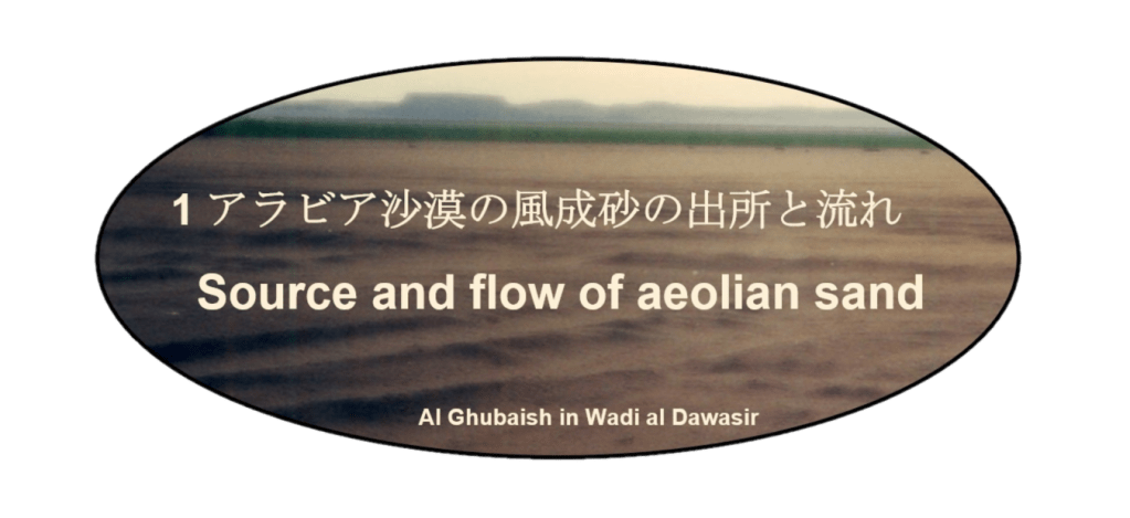


アラビア沙漠の砂の出所
アラビア半島の3分の1を被う、地球上で最大の連続した風成砂の塊は、どこから来たのでしょう。アラビア沙漠の堆積物の出所源としては、
1)アラビア楯状地の先カンブリ時代の基盤
2)主に古生代下部の石英質砂岩、
3)主にジュラ紀から新生代の炭酸塩、
4)白亜紀後期のオフィオライト、
5)新第三紀玄武岩質フィールド、
があります。
ただ、ほとんどは、古生代下部の石英質砂岩であり、先カンブリア時代の基盤がその源です。それにアラビア湾沿岸からのジュラ紀から新生代の炭酸塩が続きます。
白亜紀後期のオフィオライトは、オマーンのハジャル山脈だけに広く露出する海洋地殻の一部で、分布は、ルブア・ハーリー沙漠の東南部とワヒーバ砂に限られます。
アラビア半島内陸の熔岩地帯(harrats)およびカルスト地帯ともに砂丘を形つくる堆積物としての寄与は少ないとされています。例えば、涸れ谷ハーイル(涸れ谷ダイリア)は、新第三紀玄武岩質の風化沈殿物が広がるアジャー山塊水系を集水して、ハーイル市内通過してナフード沙漠南東部に運びます。しかし、運ばれた風化沈殿物は、ナフード沙漠の石英質砂岩に埋没してしまいます。又、フタイム熔岩地帯、ハイバル熔岩地帯、キシュブ熔岩地帯等を集水してダフナー沙漠へ流れる涸れ谷ルマによって、玄武岩質の土砂や下流域の炭酸塩質の土砂が運ばれますが、それらもダフナー沙漠の石英質砂岩に埋没してしまいます。
従って、アラビア半島内陸における砂丘を構成する風成砂の起源は、大きく2つに分かれます。一つは石英砂で、もう一つが炭酸塩岩破砕砂です。
石英砂は、古生代下部の石英砂岩からさらに繰り返しリサイクルされた砕屑性石英が組成の90%以上を占められています。この大量の酸化鉄を含む石英砂が赤い砂とも呼ばれ、ナフード沙漠からルブア・ハーリー沙漠を含むアラビア半島の砂海や砂丘地帯の大部分を被っています。赤い砂には赤から少し薄い赤褐色まで含みます。
炭酸塩岩破砕砂は、主として炭酸塩岩で構成されるティグリス・ユーフラテス系と同じく主に石灰岩で構成されるザグロス山脈の横断河川によって浸食され運ばれて、更新世の氷河時代などで干上がったアラビア湾に堆積した炭酸塩岩破砕砂が卓越風でアラビア半島に運ばれ、ジャーフーラ沙漠やアラビア湾沿岸の砂海や砂丘を作りだしました。白い砂と呼ばれ、石灰岩の白から淡い褐色まで含みます。アラブ首長国連邦とオマーンではアラビア湾から最大80キロ内陸まで、活発な砂丘は炭酸塩に富む更新世の風成堆積物(風成岩)によって覆われています。
Source of sand for the Arabian desert
Where did the largest continuous mass of aeolian sand on earth, which covers one-third of the Arabian Peninsula, come from? Sources of the Arabian desert sediments include the following formations:
1) the basement of the Arabian shield in the precambrian era,
2) the quartzose sandstone, mainly in the lower palaeozoic era,
3) the carbonate, mainly from the jurassic era to the cenozoic era,
4) the ophiolite in the upper cretaceous era,
5) the basic field in the neogene era.
However, most of them are the quartzose sandstones of the lower palaeozoic era, and their source is the basement of the precambrian era. This is followed by the carbonate from the jurassic to the cenozoic originated from the littoral zone of the Arabian Gulf.
The ophiolite of the upper cretaceous era is part of the oceanic crust that is widely exposed only to the Hajar mountains in Oman, and its distribution is confined to the southeastern part of the Rub’al Khali and the Wahibah sand.
Both harrats (lava plains) and karsts in the inland area of the Arabian Peninsula are said to have little contribution as dune-forming sediments. For example, the Wadi Hayil (formerly Wadi Dayri’) collects the Jibal Ajas range water system, where weathered sediments of the basaltic field in the neogene era spread, and transports them to the southeastern part of the An Nafud via the city of Hail. Then, the weathered sediments carried are mixed and disappeared in a huge volume of quartzose sands of An Nafud desert.
In addition, Wadi ar Rumah, which collects the Harrat Hutaym, the Harrat Khaybar, the Harrat Kishb, etc. and flows to Ad Dahna desert, carries basaltic sediments and/or carbonated sediments in the lower reaches. They will be mixed and disappeated in a big mass of quartzose sands of the Ad Dahna.
Therefore, the origin of the aeolian sands that compose the dunes in the Arabian Peninsula can be broadly divided into two. One is quartzose sand and the another is carbonaticlastic sand.
More than 90% of the composition of quartzose is detrital quartz, which is repeatedly recycled from quartza renites in the lower palaeozoic era. This large amount of iron oxide quartz sand, also known as red sand, covers most of the sandy seas and dunes of the Arabian Peninsula, from the An Nafud to the Rub’al Khali. Red sand contains from red to slightly light reddish brown.
The Zagros mountain, like the Tigris / Euphrates family, is mainly composed of carbonate rocks such as limestone. Carbonaticlastic sands were eroded and carried by the transverse rivers of the Zagros Mountains and deposited in the Arabian Gulf, which dried up in the ice age of the pleistocene. The carbonaticlastic sands were carried by prevailing winds to the Arabian Peninsula, creating sand seas and dunes in the Jafurah desert and the littoral zone of the Arabian Gulf. It is called white sand and contains white to light brown limestone. In United Arab Emirates and Oman, from Arabian Gulf to up to 80 km inland, lively dunes are covered by carbonate-rich pleistocene aeolian sediments (eolianite, etc.).
アラビア半島の風成砂の流れ
アラビア半島の風成砂は、卓越風によって四つの砂の流れとなって、北から南へと運ばれています。
ナフード沙漠からルブア・ハーリー沙漠への流れは、赤い砂の回廊です。その主流は、ダフナー回廊(沙漠)です。この回廊はトゥワイク山脈の東側を幅30〜80キロで1,200キロに及ぶ弧を描いてルブア・ハーリー沙漠まで連続しています。
第2番目は、ナフード回廊(ウルーク沙漠)で、トゥワイク山脈の西側を山脈に沿うように幾つかの砂丘列となってイルク・ワーディーまで続いています。そしてイルク・ワーディーを介してルブア・ハーリー沙漠とつながります。
第3番目は断続的ですが、ナフード・ウライク、ナフード・スィッラ、ナフード・サハー、ウルーク・スバイウ等を形成して、イルク・ワーディーへと流れています。
第4番目は、これらとは異なり、白い砂の流れで、アラビア湾岸をクウェイトからアラブ首長国連邦の沿岸沿いに連なる砂浜や砂丘および卓越風で白い砂を運ぶジャーフーラ回廊(沙漠)です。ジャーフーラ回廊は、クウェイトの南から幅20キロで流れ、アブカイクまで幅30キロと大きくは変わりませんが、ルブア・ハーリー沙漠に入ると一気に幅が250キロと薄く広がります。
Flow of aeolian sands in Arabian Peninsula
The aeolian sand of the Arabian Peninsula is carried from north to south in the four streams of sand by the prevailing winds.
The three streams from the An Nafudt to the Rub’al Khali are red sand corridors. The mainstream is the Ad Dahna corridor. This corridor extends east of Jebel Tuwaiq in an arc 30-80 km wide and 1,200 km to the Rub’al Khali.
The second is the Nafud corridor (the Uruq desert), which runs west of Jebel Tuwaiq in several dunes along the mountains to the Irq al Wadi. Then connect to the Rub’al Khali via the Irq al Wadi.
The third is intermittent, but flows to the Irq al Wadi, forming the Nafud Al Urayq, the Nafud as Sirrah, the Nafud as Sakha, the Uruq Subay, etc.
Unlike these, the fourth stream is white sand. The prevailing winds carry white sand through beaches and dunes along the coastal areas of the Arabian Gulf from Kuwait to the United Arab Emirates. The mainstream is the Jafurah corridor. The Jafurah corridor runs from the south of Kuwait to the Rub’al Khali. Its width is 20km, which is not much different from 30km in Abqaiq. However, this corridor suddenly widens to 250 kilometers when it enters the Rub’ al Khali.
