
Dune areas

ジャーフーラ沙漠
ダフナー沙漠
ナフード沙漠
ルブア・ハーリー沙漠
الجافورة
الدهناء
النفود الكبير
الربع الخالي
The Jafurah desert
The Ad Dahna desert
The An Nafud desert
The Rub’ Al-Khali
シリア沙漠
サイハド沙漠
ワヒバ砂沙漠
بادية الشام
سيهد
رِمَال وَهِيْبَة
The Syrian Desert
The Sayhad desert
The Ramlat al Wahibah
イルク・バンバーン
イルク・リスマ
イルク・ワーディー
ウルーク沙漠
ウルーク・スバイウ
スィッラ砂丘帯
ナフード・ウライク
ナフード・サハー
عرق بنبان
عرق الرثمة
عرق الوادي
عروق
عروق سبيع
نفود السرة
نفود العريق
نفود السخا
The Irq Banban
Irq Rithmah
The Irq al Wadi
The Uruq desert
The Uruq Subay
Nafud as Sirrah
The Nafud Al Urayq
The Nafud as Sakha
ナフード・マドフル
ナフード・スワイラート
ナフード・シュカイカ
ナフード・スィッル
ナフード・クナイフィザ
ナフード・ダヒー
نفود المظهر
نفود الثويرات
نفود الشقيقة
نفود السر
نفود قنيفذة
نفود الدحي
The Nafud al Mazhur
The Nafud al-Thuwayrat
The Nafud Ash Shuqayyiqah
The Nafud as Sirr
The Nafud Qunayfidhah
The Nafud al-Dahi
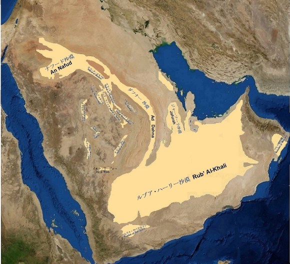
四大砂丘地帯 (Four major dune areas)
| ジャーフーラ沙漠 | The Jafurah desert |
| 沙漠の半島で唯一白いジャーフーラ沙漠は、その白い砂をクウェイトからジュベールへ下り、ダンマーム南のアブカイクからハサー・オアシスの東を通り、南のルブア・ハーリー沙漠まで砂を吹き下しています。 その延長距離は800キロに及び、幅はクウェイトで20キロ程度ですが、アブカイクでは30キロとなり、風力エネルギーが低くなるルブア・ハーリー沙漠に入ると250キロまでにも広がります。 ジャーフーラ沙漠は、卓越風向と直角に三日月型を作り出し、移動する砂丘バルハンで覆われています。その低い砂丘は毎年、目に見えて動く為、欧米人は徘徊する砂丘と呼んでいます。言い換えれば、ジャーフーラ沙漠は移動する砂丘の塊です。 ジャーフーラ沙漠の砂は石英分が90%以下と少なく、アラビア半にある他の沙漠の様に砂が酸化鉄で被覆されてないので、その結果として砂の色が明るい赤ではなく、青みがかった白です。クウェート(الكويت)からルブア・ハーリー沙漠に続くジャーフーラ沙漠およびアラビア湾沿岸の海岸砂丘では特徴的に見られます。 ジャーフーラ沙漠の特徴でもある徘徊する砂丘群の間にも冬の雨は多年生の灌木や低木を蘇らせ、毎年収穫される種に命を与えます。砂丘が比較的安定してくると砂丘の間の窪地では、しばしば、その根にハンモック状に砂をつかんだ形でまとまった低木、灌木や草で覆われます。このような地形をこの地方ではディカーカと呼んでいます。 この様な植生がジャーフーラ沙漠では幾つかの場所で、放物線状砂丘も形成させています。この他、バルカノイド尾根、横断尾根、ドーム砂丘なども発達しています。 | The only white Jafurah desert on the Arabian Peninsula blows its white sand from Kuwait via Jubail region, through Abqaiq south of Dammam, and east of Hasa oasis, to Rub ‘al Khali south. Total length is as long as 800 km. And its width is about 20 km in southern Kuwait, but it is 30 km in Abqaiq and extends to 250 km in Rub ‘al Khali where the wind energy is low. The Jafurah desert is covered with a lot of moving barchans dunes that create crescent shapes at right angles to prevailing wind direction. As low dunes move visibly every year (annually maximum 30m), westerners call them wandering dunes. In other words, the Jafurah desert is a mass of moving dunes. Sand of the Jafurah desert has a low quartz content of 90% or less, and unlike other deserts in the Arabian Peninsula, a sand grain is not covered with iron oxide, resulting in a bluish rather than bright red color. That is white. It is characteristically found in the Jafurah desert from the southern Kuwait to the Rub‘ al Khali and also in coastal dunes of the Arabian Gulf littoral zone. A wandering dune is another feature of the Jafurah desert. In interdunes among wandering dunes, winter rains revive vegetation such as perennial shrubs, annual plants and grass-bushes, giving lives to seeds harvested each year. When dunes become relatively stable, depressions between dunes are often covered with vegetation of hammock-like form holding sand between their roots. Such terrain is called dikakah in this region. Such vegetations also form parabolic dunes in some places in the Jafurah desert. In addition, the Jafurah desert has barchanoid ridge, transverse dunes, dome dune, etc. |
| ダフナー沙漠 | The Ad Dahna desert |
| ナフード沙漠からルブア・ハーリー沙漠まで1,300キロもの距離をトゥワイク山脈に沿って、その東側に幅が24〜80 キロの狭い弧を描いて細く南に延びている砂の流れが、ダフナー沙漠です。 その砂の流れは、ナフード沙漠と同じ様に酸化鉄によって特徴的に赤く染まっています。 とりわけナフード沙漠と砂丘の縦型構造を共有する北では際立っています。 全体的には葉脈あるいは静脈の意味を持ちイルーク (عرق)と呼ばれる細くて長い砂の丘陵で構成されています。 しかし、狭いにしても長いので、沙漠の面積としては45,000平方キロもあります。 砂丘の形も縦型のイルーク (عرق)ばかりではありません。 リヤードの北200キロ付近の’Urayq As-Siru Al-Aswat、’ Urayq As_Siru Al-Gharbi、および ‘Irq Al-Kannasiyahには高さ100メートルにも及ぶ大きな星形砂丘が幾つもあります。 リヤード・ダンマン高速道路の切り通し当りだと砂丘の高さもせいぜい30メートルほどですが、また、ハルジュ・ハラド道路の切り通しでも麓からはるかに見上げるほどに砂丘は高く聳えています。 NASAの衛星写真ではリヤード北西320キロに Ad Dahna sand cordonと名付けられた砂丘の急な崖のような長い縁の存在を見せています。 また、ダフナー沙漠は、ナフード沙漠よりも水が乏しいにもかかわらず、ベドインの放牧に冬と春の牧草地を提供しています。 | The Ad Dahna desert is a narrow sand stream extending 1,300 km from the An Nafud desert to the Rub’ al Khali along eastern side of the Jebel Tuwaiq in a narrow arc 24-80 km wide. Sand stream is characteristically dyed red due to iron oxide covering a sand grain, similar to the An Nafud desert. It stands out especially in north, which shares longitudinal dune structure with the An Nafud desert. Overall, it has meaning of veins or veins and is composed of long, narrow sand hills called Irq (عرق). However, even if it is narrow, it is long enough, therefore total desert area reaches 45,000 square kilometers. Shape of the dunes is not limited only to longitudinal Irq (عرق). There are several star dunes in Urayq as-Siru al-Aswat, Urayq as_Siru al-Gharbi, and Irq al-Kannasiyah, about 200 km north of Riyadh. In addition, some star dunes are as large as 100 meters high. At road cut of the Riyadh –Dammam Highway, height of dunes is about 30 meters at the most, but at road cut of the Kharj –Haradh road, dunes are so high that we have to look up far. NASA satellite images show presence of a steep, cliff-like long edge of dune named the Ad Dahna sand cordon located at 320 kilometers northwest of Riyadh. The Ad Dahna desert also provides winter and spring pastures for Bedouin to graze camels, sheep, etc., because of abundance of vegetations despite having less water than the An Nafud desert. |
| ナフード沙漠 | The An Nafud desert |
| ナフード沙漠は、砂の沙漠です。その大きさとその迫力で、しばしば偉大な砂の沙漠 (صحراء رملية كبيرة)又は偉大なナフード(النفود الكبي صحراء)と呼ばれています。 位置的には北緯27度00分から30度00分、東経39度00分から43度00分の範囲です。 西のタイマーから東のハーイルまで290キロメートル以上の延長があり、ハーイルとドゥーマ・ジャンダルの間の幅は225キロメートルと、アラビア半島北西部の広大な変形した盆地(楕円形の窪み)を埋め、その面積は67,300平方キロに及びます。(周囲を含めて、103,600平方キロとの説もあります。) アラビア半島では南にあるルブア・ハーリー沙漠に次いで第二番目に大きな砂沙漠です。この二つの砂沙漠は、砂の流れで作られたダフナー沙漠と呼ばれる長い弧型の砂沙漠でつながっています。 ナフード沙漠の名前の由来には、「砂丘を意味するニフドから次第に訛ってこの様に呼ばれる様に成った」や「砂丘の形から起源から隆起した顕著なものを意味するNuhdに成り、その複数形からナフードに変化した」などがあります。 ナフード沙漠を代表するのは赤い砂と大きな三日月形の砂丘です。 ナフード沙漠の卓越風は西から吹いて来ますので、西部に横方向の砂丘とバルカノイドの尾根があり、北と東側では数キロから十数キロ幅の谷で分けられている高さ90メートル程の数十キロの長さの縦型砂丘が累々とほぼ平行に重なり連なっています。これらの縦型砂丘列は、ハーイル地域の北東までほぼ西から東への方向に直線状に幾重にも平行に並んでいます。 そこから東に移るに連れて、北西から南東への方向に向きが変わり、ダフナー沙漠と流れて行きます。この変化には砂の流れていた場所と時期の卓越風向とその場の崖地の向きが関係しています。 ナフード沙漠の際だった特徴は縦型砂丘を形成する一つ一つの砂丘のファルジと呼ばれる凹地の形にあります。ファルジはほぼ半楕円で、馬の蹄の巨大な跡の様な形をしています。 縦型砂丘では砂は移動しても地形は殆ど変わらず、比較的安定しています。雨は年に1、2回降りますので、その凹地は、しばしば低木、シュラブや草で厚く覆われて、ディカーカとも呼ばれるハンモック状の植生のある沙漠を作り出しています。 アラビア湾地域の英国駐在代表だったJ. G.ロリマーは、「ナフドで最も印象的な現象はファルジと云う独特の砂丘の形で、形は半楕円形で巨大な馬の蹄の形に良く似ている。指が最も深い部分で常に北西を向いており、くぼ地の床は南東へと高まり、踵部分で地表と同じ高さになる。内側の壁は水平から50度ないし60度の角度に傾いている。ファルジFaljの大きさは様々で0.4ヘクタールから80ヘクタールにもおよび、平均直径は260メートルから370メートルであり、通常の深さは45メートルから75メートルである。このくぼ地に関連する奇妙な事実は砂の不安定な斜面を持っているにもかかわらず毎年そして幾世代にも渡ってその形や大きさが変わらずに残っている事である。砂丘の中で降雨があっても水を残すほどでは無く、西から東に向かって不規則なコースや筋を描いて並んでいる。」と述べています。 また、アン・ブラント夫人は、1878年にナフード沙漠を越えた際に「最初に印象的なのは、その色です。朝に濡れると真っ赤になります…しかし、不毛ではありません。それどころか、ナフード沙漠は、これまで越えたどの沙漠よりも、樹木が茂り、牧草地が豊富です。そこではガーダ(Haloxylon persicum)等の茂みで全体に房状になっています…」と述べています。(ガーダは、薪(حطب خشب)にも使える低木です。) 無数の小さな茂みとなった植物の生育によって生じるディカーカが放物線状の砂丘をつくりだしていますし、ディカーカのあるファルジ地形も大きな三日月形の砂丘に数えられるとも思っています。 ナフード沙漠には古い時代から人の営みがありました。オアシスも少なくなく、特に北部のサカーカードゥーマ・ジャンダル周辺や西部で豊かな井戸のあるタイマーの様な農場地帯があり、南部にも小さな農業地帯ながらジュッバ,ラウダ、フッタ等が並んでいます。その他にも水場としてはシャギグ、ハウアーやアズファーなどがあります。 また、タイマー周辺とか、古い湖の畔だったジュッバ等の周囲には約2,500~3,000年前の岩に刻まれた岩壁画残されています。その中でもジュッバは、2015年にユネスコの世界遺産に登録されています。 ナフード沙漠は何時の時代でも旅の障害と成っていましたが、ナフード沙漠は原住民にとても異邦人にとっても常に魅力の有る場所でした。ナフード沙漠の標高は一定では無く、ジャウフとハーイルを結ぶ隊商路の平均標高は海抜914メートルにもなります。砂丘の高さも100メートルを越すものも少なくなく、砂は柔らかく駱駝の通行でさえ難しい沙漠往来を突然の強風と砂嵐がさらに困難にしていました。 遊牧地に成っていると聞き及んで、私も2度程、ナフード沙漠入りを試みたことがありました。何回か試みた後に、古老から「隊商のナフード沙漠越えは雨が降った後の砂の締まった時期だけに限られていた」との助言を得て諦めました。 現在は、ドゥーマ・ジャンダルとジュッバ間の350キロを横断道路が完成しています。さらに、ハーイルとラフハを結ぶ道路も新設され、ハウアーからアズファー経由で、そちら方向に向かう道路が北東縁部にも付けられています。これらによって、現在のナフード沙漠は、訪れ易くなっていると思われます。 | The An Nafud desert is a sand desert. Due to its size and its unfathomable power, it is often referred to as the great sand desert (صحراء رملية كبيرة) or the great Nafud al Kabir (النفود الكبي صحراء). Positionally, it ranges from latitude 27 ° 00’N to 30 ° 00’N and longitude 39 ° 00’N to 43 ° 00’E. There is an extension of more than 290 kilometers from Tayma in west to Hayil in east, with a width of 225 kilometers between Hayil and Dumat al-Jundal. It is also a vast deformed basin (oval depression) in the northwestern Arabian Peninsula. It covers an area of 67,300 square kilometers. (There is also another opinion that it is 103,600 square kilometers including surrounding areas.) This is the second largest sand desert in the Arabian Peninsula, after the Rub’ al Khali in south. These two sand deserts are connected by a long arc of sand called the Ad Dahna desert, which is made of a stream of sand. The name An Nafud desert is derived from name “al-Nyhud, which means dunes,” and “Nuhd, which is a prominent shape of dune.” And changed from its plural to Nafud. “And there are other opinions so on. The An Nafud desert is represented by red sand and large crescent dunes. Prevailing wind directions in the An Nafud desert comes from west, consequently there are transverse dunes and barchanoid ridges in the western An Nafud desert. In the norther and eastern Hayil region, dozens kilometer-long longitudinal dunes are lined up almost in parallel from west to east. They are divided by valleys that are several kilometers to a dozen kilometers wide and are about 90 meters high. As they move east from there, they change their direction from northwest to southeast and flow into the Ad Dahna desert. These changes are related to location, time of sand flow, predominant wind direction and direction of escarpment on the spot. An another distinctive feature of the An Nafud desert is shape of depression called Falj in each dune forming longitudinal dune. Falj is almost semi-elliptical and shaped like a giant trace of a horse’s hoof. In longitudinal dune, terrain remains almost unchanged even if sand moves, and it is relatively stable. Since it rains once or twice a year, its depressions are often thickly covered with shrubs and grass-bushes, creating hammock-like vegetated shapes, which is also known as dikakah. JG Lorimer (1870 – 1914), a British diplomat in the Arabian Gulf region, said, “A striking phenomenon in the An Nafud desert is a unique depression called Falj between dunes. Its shape is semi-elliptical and look like a giant horseshoe. Deepest part of its fingers is always facing northwest, its floor rises up to southeast, and its heel part is level with ground surface. Its inner wall slopes 50 to 60 degrees from horizontal. Falj varies from 0.4 to 80 hectares in size, its average diameter is 260 m to 370 m, and its normal depth is 45 m to 75 m. It is strange that despite having an unstable slope, its shape and size remain unchanged year to year and for generations. Desert rainfall is not enough to collect water in depression. Each dune comes with one Falj. The An Nafud desert has an huge number of them, lining up in rows from west to east, even in irregular courses. “ Also, when Mrs. Anne Blunt crossed the An Nafud desert in 1878, she stated as follows. “The first thing that impresses me is its color. It turns bright red when it gets wet in the morning … but this desert isn’t barren. On the contrary, the An Nafud desert is more tree-rich than any of the deserts I’ve ever crossed. There are also abundant meadows. In addition, bushes such as ghada (Haloxylon persicum) form tufts “ (Ghada bush is a shrub that can also be used for firewood (حاب خشب).) A dikakah is produced by growth of vegetations such as small trees, scrubs and grasses, which have become innumerable small bushes. Dikakah is cause of creating parabolic dunes, and a Falj terrain with dikakah seems to be also counted as a large crescent. In the An Nafud desert, a human activity has been existed since ancient times. There are many oases specially around Sakaka and Dumat al-Jundal in north. In west there are farm areas like Tayma with rich wells, and in south there are small agricultural areas such as Jubbah, Rawdhah and Khottah. Other water areas include Shaqiq, Khaw’aa and Adhfa. In addition, drawings carved on rocks about 2,500 to 3,000 years ago are left around Tayma and around Jubbah, which was an ancient lakeside. Among them, Jubbah was registered as a UNESCO world heritage site in 2015. The An Nafud desert has always been an obstacle to travel, nevertheless this desert has always been a very attractive place not only for indigenous people but also for visitors. Elevation of this desert is changing place by place. Average elevation of caravan route connecting Jawf and Hail Hayil is 914 meters above sea level. Dune height often exceeds 100 m, and sand is so soft that even camel has also serious difficulty to make traffic. Strong winds and sandstorms made even more hard to cross over this desert. When I heard that it was a nomadic land, I also tried to enter the An Nafud desert. I tried twice and failed twice, however I gave up after receiving an advice of an old native person that “the caravan’s crossing of the An Nafud desert was limited to the time when the sand was tight after rain.” Currently, a 350 km crossing road between Dumat al-Jundal and Jubba has been completed. In addition, a new road connecting Hail and Rafha has also been constructed, together with a road from Khaw’aa via Adhfa to northeastern margin. These seem to make the An Nafud desert much easier to visit, at present. |
| ルブア・ハーリー | The Rub’ Al-Khali |
| アラビア半島の南部は空白地帯或いはルブア・ハーリーiと云う名で知られた茫漠とした沙漠地帯です。ただ、その中に住むベドウインは、単にリマール(砂)と呼んでいるだけのようです。 東はハジャール山脈、南はアラビア海沿いのドファール山脈(カーラ山脈Q、マフラ山地、ハドラマウト山地や台地を含む)、西部はトゥワイク山脈に囲まれる盆地が空白地帯です。 東西の延長が約1,200キロで南北の最大幅が650 キロ近くあります。その面積はフランス、ベルギーとオランダ三国を合わせたより大きく約650,000 平方キロもあり、世界でもっとも大きな連続する砂沙漠です。 ルブア・ハーリーの砂丘の種類は、西部南中央の孤立したドーム砂丘から広大で数しれぬ縦方向の砂丘、東南部の星形砂丘、北東部のメガバルハンまでさまざまです。もっとも支配的な長く直線的な砂丘は、卓越風と平行に形成され、長さが300 キロに及ぶものもあります。 活発な砂丘は、一般的にシャマール (شمال north)の影響下で北東から南西に並んでいます。このような砂丘は、南西部で最大250〜300メートルの高さに達する可能性があります。 もちろん、砂丘の形を認識するのが難しいことは、よくあります。複雑な砂丘は、2つ以上の砂丘タイプの組み合わせであり、風の強さと方向が変化したことを示唆しています。 なお、詳細は「8ルブア・ハーリー沙漠」の章を参照してください。 | The southern Arabian Peninsula is a vast desert area known as the Empty Quarter or the Rub’ Al Khali. Bedouins, who live in it, simply call it rimal (sand) (رمال). The Rub’ Al Khali is a slightly deformed basin. It is surrounded by the Hajar mountains to east, Dhofar mountains along the Arabian Sea to south (including the Qara mountains, the Jebel Mahrat, the Jebel Hadhramout and several plateaus), the Jebel Tuwaiq to west, and the Wadi as-Sahba to north. Its length is about 1,200 km east-west, and its width is up to 650 km north-south. Its area is larger than that of France, Belgium and the Netherlands combined, which is about 650,000 square kilometers and is the largest continuous sand desert in the world. The Rub’ Al Khali has several types of dunes. Isolated solitary dome dunes are in south-central part of its west, extensive and numerous longitudinal dunes are in its center, star dunes are in its southeast, and megabarchans are in its northeast. Long, straight longitudinal dunes are predominant, forming parallel to prevailing wind direction, some up to 300 kilometers in length. Lively dunes generally line from northeast to southwest under influence of Shamal (شمال north). Such dunes can grow up to 250-300 m high in the southwestern Rub’ Al Khali. It is often difficult to recognize dune type. Complex dunes are a combination of two or more dune types, suggesting changes both in wind strength and direction. For more details, please refer to the chapter of “Rub’ al Khali”. |
北部と南部の砂丘地帯 (Dune zones in the northern and southern Arabian Peninsula)
| シリア沙漠(بادية الشام) | The Syrian Desert (بادية الشام) |
| シリア沙漠は、アラビア半島北部の土漠で、シリア・アラビア沙漠とも呼ばれ、シリアヨルダン、イラク各国の内陸部にまたがっています。 西はシリアのオロンテス川渓谷、東はシリアからイラクへ流れるユーフラテス川渓谷に及びます。北はシリア北部の肥沃な草原・森林へ至り、南はナフード沙漠などのアラビア半島内陸の沙漠へとつながります。 多くは、東のユーフラテス川に向かってなだらかに低くなっている高原地帯で、ステップと土漠の複合した植生の荒地です。 沙漠の中にはダマスカス、パルミラ等をはじめ多くのオアシスがあり、沙漠を横切る隊商の中継地となってきました。 | The Syrian desert is a soil desert in the northern Arabian Peninsula. It also known as the Syro-Arabian desert, which spans inland areas of Syria, Jordan and Iraq. Its west is the Orontes valley of Syria, and its east is the Euphrates flowing from Syria to Iraq. Its north leads to fertile grasslands and forests in northern Syria, and its south leads to inland of the Arabian Peninsula such as the An Nafud desert. Its main parts are plateaus that gently lower towards the eastern Euphrates. It is also a waste land of complex vegetation either of steppes or soil deserts. There are many oases in this desert, including Damascus, Palmyra, etc., which have become stopovers for caravans going and coming across this desert. |
| サイハド沙漠(سيهد) | The Sayhad desert(سيهد) |
| サイハド沙漠は、ラムラト・サバアタイン (رملة السبعتين)とも呼ばれ、サイハドも(صيهد)とつづられることもあります。 サイハド沙漠は涸れ谷ハドラマウトと涸れ谷ジョウフ挟まれたイエメン西部中央北部にあります。広さは、26,000平方キロあり、ジャウフ、マアリブ、シャブワの3県をまたぐ南北100キロ東西240キロの広がりを持っています。砂丘は、比較的平坦で、ほとんど横断砂丘とセイフ砂丘で構成されています。 サイハド沙漠のマアリブ地域では紀元前23世紀にはすでにアラビア半島南部を支配したカフターン部族(が簡単な土盛りのダムと水路をに建設し、農業を営み始めました。紀元前の終わり頃の世紀には地中海でのギリシャ・ローマの台頭と同時期にサイハド沙漠に流れ込む涸れ谷の農民は巨大な都市国家群を基盤とする文明を築いていました。 これらの国家の統治者達は巨大な灌漑事業の工事を統轄しました。その中で最も有名なのがサバの首都マアリブにおける巨大ダムの建設でした。サイハド沙漠周辺の都市国家は印度洋を越えて当時地中海で大きな需要のあった香料や高級な商品を交易して富裕に成っていました。 この都市群の繁栄がローマにこの地方をアラビア・フェリクスすなはち富裕なアラビア(幸福なアラビア)と呼ばせていました。この交易にこれらの都市国家は、自家製の産物を入れました。それらがキリスト教などの祭祀と深くかかわりを持つ、有名な南アラビア産の乳香と没薬です。 | The Sayhad desert (سيهد) is also called the Ramlat al-Sab’atayn (رملة السبعتين) and is sometimes spelled as Sayhad (صيهد). The Sayhad desert is located in north central part of western Yemen between the Wadi Hadhramaut and the Wadi Jawf. It covers an area of 26,000 square kilometers and extends 100 kilometers north-south and 240 kilometers east-west across three provinces of Jawf, Marib and Shabwa. Its dunes are relatively flat and consist mostly of transverse dunes (barchanoid) and seif dunes. In Marib region of the Sayhad desert, the Qahtanites, who already ruled the southern Arabian Peninsula, built simple earthen dams and waterways in 23rd century BC and began farming. Those peasants built civilization based on a huge city-state in late century BC, which was the same time as the rise of Greece and Rome in the Mediterranean. Rulers of these city-states governed construction of huge irrigation projects. The most famous of these was the construction of a huge dam in Marib, the capital of Saba (Sheba). The city-states around Sayhad desert have become wealthy by trading fragrances and high-end products that were in great demand in the Mediterranean at that time, beyond the Indian Ocean. Prosperity of these city-states made Rome called this region as Arabia felix, that is fertile Arabia (happy Arabia). These city-states put homemade products into this trade. They were so famous as south Arabian frankincense and myrrh, which are closely related to rituals such as Christianity. |
| ワヒバ砂沙漠(رملة آل وهيبة) | The Ramlat al Wahibah (رملة آل وهيبة) |
| ワヒバ・サンド(رملة آل وهيبة)は、この沙漠に住むワヒバ族に因んで命名されていましたが、現在の正式名称はシャルキーヤ沙漠(رمال شرقية)と変更されています。 アラビア半の南東に位置し、広さは南北180キロ、東西80キロで面積は12,500平方キロです。この沙漠は、第四紀間に南西のモンスーンと北東からのシャマールと呼ばれる貿易風によって形成されました。 ワヒバ砂海は、本来は5つの地域から成り立っていますが、最も狭く、炭酸塩を含まない南西部の古い砂の多いジャビン地域を除けば、大まかには北と南の地域に分けることができます。 北ワヒバは、高いワヒバとも呼ばれ、モンスーンによって形成された南北方向の非対称で高さ80メートル、クレスト間距離1.0~1.5キロの大きなメガリッジシステムによって主に占められています。 それに対して低いワヒバとも呼ばれる南ワヒバは、南部と東部に見られる横断砂丘や線形の砂丘、砂床、サブカフィールドで構成されています。 北ワヒバの砂は苦鉄質鉱物の組成が高く、60,000~90,000年位前に形成され、主に隣接するハジャル山脈を排水する古い涸れ谷バサや涸れ谷マタム等地元のワディによって運ばれて来ました。 一方、ワヒバ南部の砂は、10,000~35,000年位前に形成され、鉱物学的に成熟した石英に富む組成を持ち、オマーン海岸または隣接するサブカ平野から供給されたと考えられます。このように、高いワヒバと低いワヒバの砂は、それぞれに別々の供給源に由来しています。 | The Wahiba sands (رملة آلوهيبة) was named after the Bani Wahiba tribe, who live in this desert, but the current official name has been changed to the Rimāl ash-Sharqiyyah (رمال شرقية). Located southeast of the Arabian Peninsula, it measures 180 kilometers north-south, 80 kilometers east-west and covers an area of 12,500 square kilometers. This desert was formed during the Quaternary period both by southwest monsoons and trade winds (easterlies) called Shamal from northeast. The Wahiba sands originally consists of five regions, but can be roughly divided into two regions (north and south), with exception of the Jabin area. The Jabin area is narrow, carbonate-free, old sandy and located in southwest. The northern Wahiba sands, also known as the upper Wahiba, were formed by monsoons. It is occupied by large megaridge systems which are asymmetrical in north-south direction and 80 m high with distance of 1.0-1.5 km between crests. On the other hand, the south Wahiba sands, also known as the low Wahiba, are composed of transverse dunes (barchanoid), linear dunes, sand sheets and sabkha fields, commonly found in south and east. Sand grains of the upper Wahiba and the low Wahiba come from different sources. Sand grains of the upper Wahiba have a high composition of mafic minerals, were formed about 60,000 to 90,000 years ago, and had mainly been carried by local wadis such as the paleo-Wadi Batha and the Wadi Matam. They drain the adjacent Hajar mountains. On the other hand, sand grains of the low Wahiba were formed about 10,000 to 35,000 years ago, have a more mineralogically mature quartz-rich composition, and were supplied from the Oman coast and adjacent sabkha plains. |
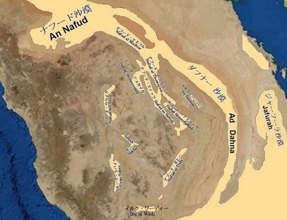
中小の砂丘地帯 (Small and medium-sized dunes)
| イルク・バンバーン | The Irq Banban |
| リヤード北北西のトゥワイク山脈とブワイブ崖地の間に細長く延びる砂丘地帯です。この砂丘帯の中には小さいながら星型砂丘もあります。 | It is a long and narrow sand dune area between the Jebel Tuwaiq and the Buwayb escarpment in north-northwest of Riyadh. There is also a small star dune in this dune belt. |
| イルク・リスマ | The Irq Rithmah |
| イルク・バンバーン北部分をイルク・リスマと呼ばれます。 | The northern part of Irq Banban is also known as the Irq Rithmah. |
| イルク・ワーディー | The Irq al Wadi |
| ハマーシーン北付近を中心に涸れ谷ダワースィル上流部の旧河床を東西におおう砂丘地帯です。 | It is a sand dune area to cover old riverbeds in upper reaches of the Wadi al Dawasir, centering on Khamasin north. |
| ウルーク沙漠 | The Uruq desert |
| ウルーク沙漠は、サウジアラビアの四大砂丘地帯に次ぐ大きさです。その細長い延長は北のカスィーム地方から南のダワースィル地方のハマーシーンまでの1,000キロに及び、湾曲しながらトゥワイク山脈の西縁をこの山脈を挟んで、その東縁に延びるダフナー沙漠とほぼ平行に並んでいます。 ウルーク沙漠は細長い砂丘地帯の集まりで、北部にはナフード・スィッル砂丘地帯が、南部にはナフード・ダヒー砂丘地帯が長い筋を描いています。ナフード・スィッル砂丘地帯の北部西側にはナフード・シュカイカ砂丘地帯がウナイザから南南東に延びています。 ナフード・スィッル砂丘地帯とトゥワイク山脈Jebel Tuwaiqの間にはワシュムと呼ばれる扇形の地形があります。その扇形の地形を挟んで、北にナフード・スワイラート砂丘地帯が横たわり、南にナフード・クナイフィザ砂丘地帯が横たわっています。 | Uruq desert is one of the following scale dunes after the four major dunes of Arabian Peninsula. Its elongated extension is 1,000 kilometers from the Qasim region in north to Khamasin in the Wadi al Dawasir region in south, curving along western edge of the Jebel Tuwaiq, almost parallel to the Ad Dahna desert extending along its eastern edge. The Uruq desert is a collection of elongated dunes with long lines of the Nafud al Sirr in north and the Nafud al Dahi in south. On northwestern side of the Nafud al Sirr, the Nafud ash Shuqayyiqah extends south-southeast from Unayzah City. Between the Nafud al Sirr and the Jebel Tuwaiq, there is a fan-shaped terrain called the Washm. the Nafud al Thuwayrat lies to north and the Nafud Qunayfidhah lies to south sandwiching this fan-shaped terrain. |
| ウルーク・スバイウ | The Uruq Subay |
| アラビア楯状地にある砂丘地帯で、メッカ街道南のリヤード州とメッカ州の州境付近に位置します。サラワート山脈のターイフ・バーハ間の山稜から北東斜面を集水する内陸型涸れ谷スバイウと涸れ谷ランヤが流れ込んでいます。 | A sand dune in the Arabian shield, located near border between Riyadh emirate and Mekkah al Mukarramah emirate, south of Mecca Road. The Uruq Subay receives flow from Wadi Subay, Wadi Ranyah, etc. They are inland wadis that collect water on northeastern slopes originating from ridge between Taif and Bahah in the Sarawat Mountains. |
| スィッラ砂丘帯 | The Nafud as-Sirrah |
| ナフード・スィッラとも転写され、冬場には水の流れもある涸れ谷スィッラはザリム東北東190キロ、リヤードの西340キロでメッカ街道を横切ります。 これに平行して、メッカ街道の南には赤い砂丘の帯が横たわり、幾つかの目立って大きな砂山があるスィッラ砂丘帯が南へと広がっています。 涸れ谷スィッラの更に西10キロでメッカ街道に近づく赤い砂丘の帯がサカー砂丘帯です。この砂丘帯は遠くでは広く大きな砂丘の連なりですが、メッカ街道を横切る辺りでは僅か数十メートルの幅に成っています。 スィッラ砂丘帯やサカー砂丘帯等の赤い砂丘の帯がこの様に完全に火成岩で出来ているアラビア盾状地の奥深くに存在するのは私には大変不思議に思えました。 かってはウルーク沙漠やダフナー沙漠と同じ様にナフード沙漠から直接あるいはカスィーム付近で分岐してダワースィル地方へと向かう北から南への砂の流れがあったと理解しています。 これらの砂の流れはイルク・ワーディーを含むおおきな砂原でウルーク沙漠と合流してルブア・ハーリー沙漠iに流れ込んでいます。更に南へとナジュラーン方面へと向かう砂も、最終的にはルブア・ハーリー沙漠に流れ込むと考えています。 | The Wadi as-Sirrah crosses the new Makkah road (Riyadh –Makkah highway) 190 km east-northeast of Zalim and 340 km west of Riyadh. This Wadi preciously has a stream of water in winter. In parallel with this wadi, a band of red dunes lies south of the new Makkah road. This is the Nafud as-Sirrah. The Nafud as-Sirrah extends south and has some prominently large sand mountains. 10 km further west of the Wadi as-Sirrah, there is another band of red dunes approaching the new Makkah road. This is the Nafud as-Sakha. This dune belt has a large chain of dunes in the distance, but is only a few dozen meters wide across the new Makkah road. It seemed very strange that bands of red sand dunes such as the Nafud as-Sirrah and the Nafud as-Sakha exist deep inside the Arabian shield, which is made entirely of igneous rocks. There might use to be a north-south sand flow from the An Nafud desert to the Wadi al Dawasir region, either directly or via Qasim, like the Uruq desert and the Ad Dahna desert. These sand streams merge with the Uruq desert in the Irq al Wadi to form a large sand erg that flows into the Rub’ al Khali. There is also sand heading south from the Irq al Wadi towards Najran. They will eventually flow into the Rub’ al Khali. |
| ナフード・ウライク | The Nafud Al Urayq |
| 涸れ谷ルマ中流部南40キロ付近をほぼ南北に延びる砂丘帯で、そのうちの2,036平方キロがナジュド地方での自然保護区の一つに指定されています。 | The Nafud Al Urayq is a sand dune zone that extends approximately 40 km south of the middle reaches of the Wadi ar Rumah. A part of the Nafud Al Urayq is designated as one of the nature reserves in the Najd region. This area is 2,036 square kilometers. |
| ナフード・サハー | The Nafud as Sakha |
| 沙漠の半島横断道路(新メッカ街道)のZalim東北東165キロ付近から南へと延びる砂丘地帯です。涸れ谷スィッラの更に西10キロでメッカ街道に近づく赤い砂丘の帯がサハー砂丘帯です。この砂丘帯は遠くでは広く大きな砂丘の連なりですが、メッカ街道を横切る辺りでは僅か数十メートルの幅に狭まっています。 | The Nafud as Sakha is a sand dune zone extending south from 165 km east-northeast of Zalim on the new Mecca road (one of the Arabian Peninsula crossing roads). For more details, please refer to The Nafud as-Sirrah. |
ウルーク沙漠を構成する砂丘地帯 (Dune zones in the Uruq desert)
| ナフード・マドフル | The Nafud al Mazhur |
| 涸れ谷ルマと涸れ谷バーティンの境をダフナー砂丘帯が横断するる部分を挟んで北からナフード・スワイラートと対峙しています。 | It faces Nafud al-Thuwayrat from north across boundary between Wadi ar Rumah and Wadi al Batin. The Ad Dahna desert also crosses this boundary. |
| ナフード・スワイラート | The Nafud al-Thuwayrat |
| ズィルフィー西を北北西から南南東へカスィーム・リヤード道路を挟んで延びています。 | It extends west of Zilfi from north-northwest to south-southeast across the Qasim–Riyadh Road. |
| ナフード・シュカイカ | The Nafud Ash Shuqayyiqah |
| カスィーム地方にあり、ウナイザから南南東へと延びています。 | It is located in the Qasim region and extends south-southeast from Unayzah. |
| ナフード・スィッル | The Nafud as Sirr |
| カスィーム地方のウナイザ東からアラビア半島横断道路(新メッカ街道)のムザーヒミーヤとクワイイヤの中間を通り、ナフード ダビーへと細長く延びています。 | It extended from the east of Unayzah in the Qasim region to the Nafud al-Dahi, crossing the new Mecca road between Muzahimiyah and Quwayiyah. |
| ナフード・クナイフィザ | The Nafud Qunayfidhah |
| トゥワイク山脈に沿って、シャクラーからムザーヒミーヤへ延びています。 | It extends from Shaqra to Muzahimiyah along the Jebel Tuwaiq. |
| ナフード・ダヒー | The Nafud al-Dahi |
| トゥワイク山脈南部西側を平行して、涸れ谷ビルク源頭西からワーディー・ダワースィル地方へと並んで延びています | It extends parallel to the Jebel Tuwaiq in its southwestern side from west of upstream of the Wadi Birk to the Wadi al Dawasir region. |
