
Water wells and settlements in the Rub’ al Khali
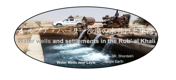

ルブア・ハーリー沙漠の水井戸と集落の一覧
List of Water wells and settlements in the Rub’ al Khali
| アブル | العبر | Al Abr |
| アラダ | عردة | Ardah |
| アルアイン | العين | Al Ayn |
| イブリー | عبري | Ibri |
| ウバイラ | العبيلة | Ubailah, Al Ubaylah |
| ウバール | وبار | Ubar |
| カルヤ・ファーウ | قرية الفاو | Qaryat al Faw |
| ザアブロトン | ذعبلوتن | Dhabloton (Thablotin) |
| サラーラ | صلالة | Salalah |
| シャイバー | الشيبة | Shaibah (Shaybah) |
| シャカ | شقة | Shaqa |
| シャルーラ | شرورة | Sharourah |
| シャワーラ | شوالة | Shawalah |
| シュバイタ | شبيطة | Shubaytah |
| スィフマ | السحمة | As Sihmah |
| スライル | السليل | As Sulayyil |
| ダファラ | الظفرة | Dhafara |
| ディバイ | Dhiby | |
| ナジュラーン | نجران | Najran |
| ハウール・ビン・アタリト | خور بن عتريت | Khaur bin Atarit |
| ハシー | خور بن عتريت | Hassi or Hashi |
| ハバの水井戸 | بئر خبا | Khaba water well |
| ハラド | حرض | Haradh |
| ハルヒール (ヒルヒール) | الخرخير | Kharkhir or Khirkhir |
| ハン(ヒン) | الخن | Al Khan or Khinn |
| ブライミー | البريمي | Buraimi |
| マンワフ | منوخ | Manwakh |
| ムガシン | مقشن | Mughshin |
| ムカッラー | المكلا | Mukalla |
| ヤブリーン | يبرين | Yabrin |
| ライラ | ليلى | Layla |
| リーワー | ليوا | Liwa |
| ワディーア | الوديعة | Wadi’ah |
ルブア・ハーリー沙漠の水井戸と集落の説明
Descriptions for water wells and settlements in the Rub’ al Khali
| アブル | Al Abr |
| 砦を意味するアブルの付く地名は、ハドラマウト県北部には幾つかあるようです。現在、アブルと明記されているアブル地区の本拠地は、ワディーア南110キロのサウジアラビアへの新設された道路の分岐ミンタカト・アブルから少し東に寄った位置にあります。このため、セシジャーが二回目の空白地帯横断の前に立ち寄ったとは違う場所と思われます。周囲で巨石遺跡が発見され、砦に守られるように水井戸の集まりがあります。Google Earthでは確認できませんが、小さな飛行場もあるそうです。 | There seem to be several place names with Al Abr, which means a fort, in the northern part of Hadramawt province. Home of the Able district, now labeled Al Abr, is located a little east of Mintuq Al Abr, which is new road junction to Saudi Arabia, 110 kilometers south of Wadi’ah. For this reason, it seems to be a different place from Al Abr, where Wilfred Thesiger stopped before the second crossing of the Rub’ al Khali. However, megalithic ruins have been discovered in the surrounding area of current Al Abr, and there are a group of water wells to be protected by the fort. It can’t be confirmed on Google Earth, but it seems that there is a small airfield. |
| アラダ | Ardah |
| ウンム・サミームの西側のオマーン国境を越えたサウジアラビア領内にある集落です。2010年のサウジ国境警備隊用空港増設承認によって飛行場が設けられました。この他に役所とスパーマーケットもあります。 | Ardah is a small air-port settlement in Saud territory adjacent to Oman border in the western Umm al Samim. This airfield was established by Saudi border guard airport expansion project in 2010. There are also Ardah governmental administration center and a supermarket. |
| アルアイン | Al Ayn |
| アルアインはアラブ首長国連邦(UAE)四番目の都市でありながら、景観が厳しく管理された美しい田園都市です。オマーンのブライミは双子ともいえるオアシスで全体としてタワム・オアシスとも呼ばれます。両国の国境に位置していますが、相互に検問所は無く自由に行き来できます。人々の居住は新石器時代に始まり、ファラジを使って農業が営まれる一方で重要な交易路拠点でした。青銅器時代のウンム・アン=ナール文化の遺跡群はファラジ灌漑を含め、2011年にUNESCOの世界遺産に登録されています。セシジャーが1946年に第一回空白地帯を横断に成功した後、食料調達を待つ間、このオアシスでドゥル族長老が持つ崖地のキャンプに暫く滞在していいます。 | Al Ayn is the fourth largest city in the United Arab Emirates (UAE), yet a beautiful garden city with tightly controlled landscapes. Oman’s Buraimi is a twin Oasis and is also known as Tawam Oasis (واحة توأم) as a whole. Although it is located on the border between the two countries, there are no checkpoints and you can come and go freely. People’s settlements began in the Neolithic era, and while farming was carried out using falaj, it was an important trade route hub. The Bronze Age Umm al-Nar cultural heritage site, including falaj irrigation, was listed as a UNESCO World Heritage Site in 2011. After Wilfred Thesiger’s first successful crossing of the Rub’ al Khali in 1946, he spends some time in this oasis. An elder Duru’ invited him in a cliff camp while he was waiting for food supply. |
| イブリー | Ibri |
| オマーン西北部ハジャル山脈南東の麓にある町です。発祥は古く紀元前3千年紀です。世界で最も完全で保存状態の良い集落と墓地遺跡が残され、バハラ城塞や、ユネスコによって世界遺産と文化遺産に分類されたバットの町の遺跡があります。 | The Hajar mountains are located in northwestern Oman. Ibri is a town at the southeastern foot of the Hajar mountains. It originated in the 3rd millennium BC. The world’s the most complete and well-preserved settlements and cemetery ruins remain. They include Bahla fort, archaeological complex of Bat, al-Khutm and al-Ayn. These are classified as World Heritage Sites and Cultural Heritage Sites by UNESCO. |
| ウバイラ | Ubailah, Al Ubaylah |
| 空白地帯中心部でヤブリーン南東250キロにのある集落で、水井戸と飛行場が有ります。(語源はふくよか)1953年から1955年にかけてARAMCOが試掘性を掘削していますが、商業量の原油は発見されませんでした。 | A village located 250 kilometers southeast of Yabrin in the center of the Rub’ al Khali, with a water well and an airfield. (Etymology is plump) ARAMCO drilled exploratory drilling from 1953 to 1955, but no commercial amount of crude oil was found. |
| ウバール | Ubar |
| 「ウバーとも転写されるウバールは『千本柱の都市』です。この都市はアラビア半島南部の空白地帯沙漠にあって紀元前3000年から1世紀頃まで交易の中心として繁栄していましたが、歴史の中に忽然として消えた『伝説の失われた都市』である」と云われています。クルアーンでは「ウバールはノアのひ孫のアードの一族が作った町で、石の偶像神を崇拝する邪悪な人々が住んでいた。預言者フードが『この町は頽廃し、繁栄を維持できなくなった』と警告するとアードの息子で王であったシャッダドは、これを無視し、反抗した。この為、神はこの町を滅ぼし、砂の中に埋めてしまわれた」と書かれていると言います。 シャッダドについての出来事はアラビアンナイトの中でも語られています。この「伝説の失われた都市」を探す為に1980年代からナサの衛星写真等を使って乳香の道を解析し、オマーンのズファール地方に、この「伝説の失われた都市」の所在の可能性を見出されました。1992年にラヌルフ・ファインズ、ジュリス・ザーリンス等からなるアメリカ調査団がシスルと云う泉の傍の16世紀にシスル砦のあった場所でその水源と成った鍾乳洞を発掘し、300年から500年の間に大きな鍾乳洞陥没で地下に埋没した建造物を発見しました。この鍾乳洞は更に発掘中ですが、ほぼ、ウバールと特定されています。 | Ubar is “City of a Thousand Pillars, Iram of the Pillars or Wabar”. This city, located in the Rub al Khali Desert (the Empty Quarter) in the southern Arabian Peninsula, prospered as a trading center from 3000 BC to 1st century BC, but disappeared suddenly in history. That is a “legendary lost city”. It is written in Qur’an as follows; Ubar was a town created by Ad (A’ad)’s family. (Ad (A’ad) is Noah’s great-grandson.) Ubar was inhabited by evil people who worshiped a stone idol. When the Prophet Hud warned that “the city is decadent and unable to sustain prosperity”, Ad’s son and king Shaddad ignored it and rebelled. Because of this, God destroyed this city and buried it in sand. This event is also mentioned in “Book of One Thousand and One Nights”. In order to find this “legendary lost city”, ancient frankincense routes were analyzed using “NASA’s satellite photography Remote Sensing Images” etc., from the 1980s, and a possibility was found that this “legendary lost city” is located in the Dhofar region of Oman. In 1992, an American research team consisting of Ranulph Fiennes, Julis Zarins, etc. excavated a limestone cave that was water source of “16th century Fort Shis’r” located near a spring called Ash Shisar (Ash Shisr). A structure, buried underground between 300 and 500 years, was found in a large limestone cave depression. This limestone cave is under excavation, but is mostly identified as Ubar. |
| カルヤ・ファーウ | Qaryat al Faw |
| 古代にはズー・カハルと呼ばれていたカルヤ・ファーウは、リヤード南南西700キロ、ナジュラーン北北東290 キロで、ワーディー・ダワースィル南80 キロの涸れ谷ヒンウの上流部シャイーブ・ファーウがトゥワイク崖地を貫いている個所の右岸に位置しています。この城塞都市は駱駝隊商路に栄え、キンダ族の支配下(紀元前1世紀から4世紀頃)にありました。 キンダ族は、カフターン部族カフラーン族に属し、シバ王国 (c. 8th C. BC – AD275)を形成していました。紀元前25年にシバ王国がヒムヤル王国によって最初に征服された後、キンダ族の一部が駱駝隊商路の拠点であったカルヤ・ファーウに移住してきたのだと思われます。その後に復活し、西暦275年まで続いたシバ王国との関係は、良好ではなく何度か戦いがありました。 アラビア語で楽園都市を意味するカルヤ・ハムラーウおよびザート・ジナーンと呼ばれる裕福な部族都市は、アラビア半島南部からナジュラーンを経てエジプトのアレクサンドリア西のアラブ湾やメソポタミアへと延びる交易路の東部分の重要な交易拠点へと発展しました。カルヤ・ファーウが半島中央部の経済的、宗教的、文化的そして社会的中心であった時代(紀元前200年から西暦200年頃)は、第一期キンダ王国とも呼ばれています。 | Qaryat al Faw, formerly known as Dhu Kahl, is located 700 kilometers south-southwest of Riyadh, 290 kilometers north-northeast of Najran and 80 kilometers south of the Wadi al Dawasir region. There, the Sha’ib al Faw, upstream of the Wadi al Hinw, runs through the Jabal Tuwaiq. Qaryat al Faw is located on right bank of the Sha’ib al Faw This fortified city prospered as a trading base on the camel caravan route and was under control of the Kindah tribe (c. 1st-4th centuries BC). The Kindah belonged to the Qahtan-Kahlan tribe and formed Kingdom of Sheba or Saba’ (c. 8th C. BC — AD 275). After Kingdom of Sheba was first conquered by Himyaritic Kingdom in 25 BC, some of the Kindahs migrated to Qaryat al Faw, a trading base on the camel caravan route. The relationship with Kingdom of Sheba, which then revived and lasted until 275 AD, had not been good and there were several battles with it. This wealthy tribal city was called Qaryat al-Hamraa or Dhat al-Jinan, which means a paradise city in Arabic, and was located in the eastern part of the camel caravan route extending from the southern Arabian Peninsula through Najran to the Arab gulf and Mesopotamia. The Arab gulf is located in west of Alexandria of Egypt. Qaryat al Faw had also developed into an important trading bases on the camel caravan route. The period when Qaryat al Faw was an economic, religious, cultural and social center of the central Arabian Peninsula (200 BC-200 AD) is also known as First Kindah Kingdom. |
| ザアブロトン | Dhabloton (Thablotin) |
| サウジアラビア南東部のオマーン国境に孤立した「恐ろしい」と言う名の村です。ダンマームから約1,200 キロ離れていますが、東部州に属し、モスクや男女それぞれの小中学校もあります。道路は無く国境警備隊の道路で400キロ離れたアラダ空港まで行けば、サウジアラビアの道路網とつながります。その他に80キロ東に離れたオマーンのムガシンで、マスカットとサラーラ間の高速道路に出られます。 現在は、北北東13.5キロ付近にザアブロトン空港が設けられていますが、国境警備隊用と思われます。 | Dhabloton is a village named “dreadful” isolated on the Oman border in the southeastern Saudi Arabia. In spite of approximately 1,200 kilometers far from Dammam, it belongs to the eastern province (Ash-Sharqiyyah) and has mosques and elementary and junior high schools for men and women. There are no roads except a border guard road which leads to Ardah Airport, 400 kilometers away, which connects you to Saudi Arabian network of roads. Oman’s Mughsin (Mughshin) is located at 80 kilometers east of Dhabloton. If crossing a desert, it is possible to take Muscat-Salalah highway passing through Mughsin (Mughshin). Dhabloton Airport is located at 13.5 kilometers north-northeast of Dhabloton, but it is an airport for Saudi Arabian Border Guards. |
| サラーラ | Salalah |
| Salalah is a city on the Arabian Sea coast, with the Al-Qara Mountains in its background. Refer to Chapter “6 Dunes” for more information. | Salalah is a city on the Arabian Sea coast, with the Al-Qara Mountains in its background. Refer to Chapter “6 Dunes” for more information. |
| シャイバー | Shaibah (Shaybah) |
| ルブア・ハーリー沙漠の東北部キダン地方にあり、この沙漠の北縁部から40キロ、アブダビ・サウジアラビア国境から10キロ南にあって、リーワー・オアシスと対峙しています。 シャイバー油田の開発のためにARAMCOが設けた石油基地の町です。この油田が発見されたのは1967年ですが、本格的に開発されたのは今世紀に入ってからでした。原油生産量は日産100万バレルで、この他に随伴ガスや周囲のガス田からの回収したガスも生産してアブカイクにパイプラインで送っています。 この石油基地のために386キロの高速道路が建設され、人員と貨物輸送のためにBoeing 737が離着陸できる空港も設けられています。また、この高速道路は、2021年末にオマーン国境のRamlet Khelahまで延長され、ハサーとイブリーが直接結ばれるとの両国政府発表が同年12月初旬にありました。 | Shaybah is located in the Kidan region of the northeastern Rub’ al Khali, 40 kilometers south from the northern edge of this desert. There is Abu Dhabi-Saudi Arabia border line 10 kilometers north of Shaybah. Shaybaht faces the Liwa Oasis region in north beyond this border. Shaybah is a base town established by ARAMCO to developed the Shaibah Oil Field. This oil field was discovered in 1967, but it wasn’t fully developed until the turn of 21th century. Crude oil production is 1 million barrels per day. And in addition to this, it also produces gas associated with crude oil, and natural gas recovered from surrounding gas fields. They are partially separated and transported to Abqaiq by pipelines. A 386 kilometers highway had newly been built for Shaybah, and an airport was provided to accommodate Boeing 737s which transport personnel and freight. This highway is also extended to Ramlet Khelah on the Omani border at the end of 2021. The both governments announced in early December, 2021 that Al Hasa and Ibri would be directly connected through Shaibah. |
| シャカ | Shaqa |
| ルブア・ハーリー沙漠(空白地帯)(Rub’ al Khali)南西部で、ナジュラーン(Najran)の東312キロ、シャルーラ(Sharourah)西北西35キロに在る水井戸です。砂丘群は灼熱で干上がった場所との印象が一般的ですが、砂丘群は乏しい雨を吸収しその底部の不浸透層の上に稀少な水源として貯えてくれます。この井戸もその様な浅層水を水源としていると思われます。道路わきにポンプ小屋と高架水槽の設けられており、ここを通るときは、いつも給水車が何台か列をなしていました。 | A water well located in the southwestern Rub’ al Khali, 312 kilometers east of Najran and 35 kilometers west-northwest of Sharourah. Sand dunes generally impresses a scorching and dry place. In fact, sand dunes absorb scarce rain and store rain as a rare shallow water source above impermeable layers at their bottoms. This well also uses such shallow water as its water source. There was a pump hut and an elevated water tank on road side, and there were always several water tankers lined up to receive water. |
| シャルーラ | Sharourah |
| ナジュラーンからイエメン国境に沿って東332 キロ付近に空軍基地の町シャルーラがあります。ナジュラーンから東248キロのハシュム・グラーブへの分岐の丁字路からシャルーラまでの64キロは道路は砂丘列の稜線と平行に東北東から西南西方向へと作られており、広い谷間を抜けている様な錯覚がします。丁字路から64 キロ東に水井戸(シャカ(Shaqa))があります。道路はここから東北東から東南東に向きを変えます。水井戸から20 キロでシャルーラの北ゲートに到着します。この町は鉄条網のフェンスで完全に囲まれています。 第19ファルーク旅団等シャルーラ軍の大規模な軍隊駐屯にサービスする4万人の市民がシャルーラには住んでいます。大きなシャルーラ基地軍事病院とは別の病院、ジェラート・アイスクリーム、都市村落省の水泳プール、動物の数は少ないが、動物園等が見られました。又、4つ星のシャルーラ・プラザ・ホテルSharurah Plaza Hotelを始め、幾つかの3星等18軒のホテルがあります。シャルーラ空港には軍用として使われている他、サウディア(民需用航空会社)も乗り入れています。シャルーラは戦略的な位置にあり、この地方でのサウジ政府軍の強い存在が1934年のサウジ・イエメン戦争の終わりに失った領土奪回を狙うイエメン試みを阻止して来ました。 | A powerful air force base town Sharourah is located 332 kilometers east of Najran along the Yemen border. The junction of road going to Khashm Ghurab is located 248 kilometers east of Najran on Najiran-Sharourah road. Shaqa well is 64 kilometers east of this junction. Among this 64 kilometers distance, this road runs from east-northeast to west-southwest parallel to ridgelines of sand dunes surrounding this road, giving an illusion of passing through a wide valley. From Shaqa well to further east, this road turns its direction from east-northeast to east-southeast. This road reaches Sharourah north gate 20 kilometers from Shaqa well. Sharourah is completely surrounded by barbed wire fences. Sharourah is home to 40,000 citizens who serve to Sharourah army and its large-scale military garrison, including Nineteenth Al Farooq Brigade Group. There are a large military hospital, civil hospitals, Gelato ice-cream, swimming pools of Sharourah municipality, and its zoo with a limited number of animals. There are also 17 hotels, including several 3-star hotels, other than 4-star Sharurah Plaza hotel. Sharourah Airport serves not only for military purposes, but also for a civilian airline such as Saudia. Sharourah is located at a strategic location and Saudi government forces has stationed, there. This strong presence of in this location has been thwarting Yemen’s attempts to recapture territories lost in end of 1934 Saudi-Yemen War. |
| シャワーラ | Shawalah |
| ルブア・ハーリー沙漠(空白地帯のハラドと間(620キロ)の沙漠道路沿いで、ハラド南131 キロに或る集落です。私が訪れた時には給油所がは廃棄されており、その先の給油所の存在が分からず、ここから引き返さざるを得ませんでした。 | This is a village 131 kilometers south of Haradh, along 620 kilometers desert road between Haradh and Al Khirkhir, which runs through the central Rub’ al Khali. When I visited, a gas station was abandoned, and any information about existence of next gas station was not available. Accordingly, I had not any other alternative than returning back from there. |
| シュバイタ | Shubaytah |
| ルブア・ハーリー沙漠のアラブ首長国連邦(UAE)南国境付近西部のダファラ地方にあるサウジアラビア領の集落で、飛行場があります。「2020 Dakar Rally」の折り返し地点となったことで最近、この名が知られるようにました。 | The Dhafara region straddles Abu Dhabi and Saudi Arabia in the northeastern Rub’ al Khali. Shubaytah is a Saudi Arabia settlement in the Dhafara region and has an airfield. It seems that it was selected one of turning points of “2020 Dakar Rally” because of this airfield. That’s why the name Shubaytah has recently become known worldwide. |
| スィフマ | As Sihmah |
| ルブア・ハーリー沙漠(空白地帯)のオマーン・サウジ国境南東端付近の呼称です。 | As Sihmah is the name near the southeastern end of the Oman-Saudi border in the southeastern Rub’ al Khali. |
| スライル | As Sulayyil |
| リヤードの南575 キロに位置する町です。豊かな農業地帯ワーディー・ダワースィル地方の北東部にあり、住人の多くは、王族とも関係の深いダワースィル族です。ルブア・ハーリー沙漠への入り口の一つでもあり大規模農園が沿線に点在する道路が涸れ谷ダワースィルの河床を東に延び、また南へとハシーに向かう道路もつけられています。 | As-Sulayyil is located 575 kilometers south of Riyadh. As-Sulayyil is in the northeastern part of the Wadi Dawasir region which is one of rich agricultural areas in Saudi Arabia, many of its inhabitants are the Dawasir tribe, who are also closely associated with the royal family. It is also one of the entrances to the Rub’ al Khali, and one road extends to east along the riverbed of the Dawasir Valley dotted with large-scale farms. And another road runs to south to access Hassi (Hashi). |
| ダファラ | Dhafara |
| シャイバー砂丘帯よりも西で、現在のサウジアラビア領のアラブ首長国連邦(UAE)南西部に近い国境を挟んだ南北の地域です。北のアブダビ領では海岸線までを含みます。このダファラ行政区は6万平方キロに及び、アブダビの陸上油田・ガス田の殆どを有しています。一方の南のサウジアラビア領にはシュバイタやカバ井戸などがあります。なお、100万BPD規模のシャイバー油田は、この地帯の東に隣り合うキダン地域に属します。 | The Dhafara region is located in the northeastern Rub’ al Khali. This region is west of the Uruq Shaibah. This region consists of 2 areas. One is the western Abu Dhabi and the another is Saudi Arabian territory expanding to south form Abu Dhabi border. Abu Dhabi territory Dhafara includes up to coastline, covers 60,000 square kilometers and owns most of Abu Dhabi’s onshore oil and gas fields. In contrast to this, Saudi Arabia territory in south includes only Shubaytah and Khaba water wells. The Shaibah oil field, which produces 1 million bpd of crude oil, belongs to the Kidan area, which is adjacent to east of the Dhafara region. |
| ディバイ | Dhiby |
| 近年になっても長い間、ヤブリーンとアブダビの間には、ディバイと云う水井戸が地図に記されているだけでした。この井戸は、1930年から1931年にかけて、ルブア・ハーリー沙漠(空白地帯)を最初に横断したバートラム・トーマスがその砂丘地帯横断大旅行の最後に位置を確認しています。 | For a long time in recent years, there was only a map of a water well called Dhiby between Yabrin and Abu Dhabi. Bertram Tomas is the first person to cross the Rub’ al Khali from 1930 to 1931. Bertram Tomas had confirmed existing and location of Dhiby water well at end of his Rub’ al Khali crossing. |
| ナジュラーン | Najran |
| ナジュラーンは深い涸れ谷の谷底に延びる細長い古い町で、ルブア・ハーリーの南西の外れにあります。イエメンとの国境の町で、ナジュラーン州の州都です。ナジュラーン州の州都でもあります。この不規則に広がったオアシスには4,000年前から人が住み続けており、かつては乳香の道の中継地でもありました。イエメン文化の影響はサウジアラビアの何処よりも強く受けており、その伝統は建築やナジランの人々の振る舞いに見ることが出来ます。 ナジュラーンにはアラビア語で「扉を開閉する為の木枠」とか、「喉の渇き」との意味に加えて、「削られた谷」との意味もあります。この涸れ谷はそれを実証している様に険しいので私にはこれが相応しく思えます。この涸れ谷はイエメン方面からも豊富な水を集めて沙漠の谷間に豊かな緑の園を生み出しています。この町の上流にスイスの会社が建設したナジュラーン渓谷ダムは、代表的なサウジの治水ダムです。 | Najran is an elongated old town that extends in a deep wadi valley, on the southwestern outskirts of the Rub’ al Khali. It is a border town with Yemen. And also, it is the capital of Najran province. This irregularly spread oasis has been inhabited for 4,000 years and was once a trading base on the frankincense route. Yemen cultural influence is stronger than anywhere else in Saudi Arabia, and its tradition can be seen in architecture and peoples’ behavior of Najran. Najran means “wooden frame for opening and closing doors”, “thirst”, etc.in Arabic. This wadi valley is so steep that “shaved valley” might be more suitable name for Najran. This wadi valley also collects abundant water also from Yemen territory to create a rich green garden in this desert valley. The Al Madhiq dam, built by a Swiss company upstream of the town, is a typical Saudi Arabian dam for flood control as well as irrigation water storage. |
| ハウール・ビン・アタリト | Khaur bin Atarit |
| ルブア・ハーリー沙漠南東部ムガシンの120キロ北にある駱駝も嫌う苦い水の井戸です。その北は石膏が粉に成った平原の上に聳える大きな砂丘地帯で、さらに北には以前の大雨のお蔭で緑に覆われた大きな砂丘もありました。また、1990年2月から3月にかけてのNCWCD(野生生物保護開発委員会)が行った鳥類探査の際に(20041’N 54042’E)でヨシ(Phragmites)が水辺に茂った40ha余の湧水湿地を発見しています。 | It is a bitter water well that even camels hate to drink, 120 kilometers north of Mughshin in the southeastern Rub ’al Khali. To north a large sand dune is towering over a plastered plain, and to further north there was also a large sand dune in green vegetation born by blessing previous heavy rains. In addition, during the bird exploration conducted by the NCWCD (Wildlife Conservation and Development Committee) from February to March 1990 (20041’N 54042’E), Phragmites (large perennial reed grasses) covered over 40 ha of spring wetlands on the water’s edge. Those wetlands were newly discovered in this the bird exploration. |
| ハシー | Hassi or Hashi |
| 涸れ谷ヒンウの上流部シャイーブ・ファーウとの境付近の右岸にある水井戸で、現在では円形農場を営む6、7軒の部落があります。ワーディ・ダワースィルの町スライルからタールマック道路が通じています。セシジャーの探検第二回空白地帯横断 (1948)では、最初の目的地でした。 | This is a water well on the right bank at the place where the Sha’ib al Faw turns into the Wadi al Hinw in its lower reaches. There is a village of 6 or 7 farmers running center pivot farms. A Tarmac Road leads from Sulayyil in the Wadi al Dawasir region. When Wilfred Thesiger conducted his second crossing of the Rub’ al Khali (1948), Hassi was his first destination. |
| ハバ(カバ)の水井戸 | Khaba water well |
| 現在のサウジアラビア領のアラブ首長国連邦南西部に近い国境地帯ダファラのほぼ東南の外れにある水井戸です。位置的にはシュバイターの南でウバイラーとほぼ同じ緯度にあります。少し塩辛いですが、飲料用に使えるそうです。1946年ウィルフレッド セシジャーは、第一回ルブア・ハーリー沙漠横断の際に高さ210メートルにも及ぶウルーク・シャイバーをなんとか越えた2日後にこの水井戸に着きました。セシジャーは、この少し塩辛い井戸水を美味くと味わいながら、苦しかった横断の成功を噛みしめていました。 | It is a water well in the southeastern outskirts of Saudi Arabia Dhafara in the northeastern Rub’ al Kali. It is located south of Shubaytah and at about the same latitude as Ubaylah. It’s a little salty, but it seems to be usable for beverages. In 1946 Wilfred Thesiger arrived at this well, two days after he managed to cross 210 meters high Uruq ash Shaybah on his first crossing of the Rub’ al Khali. While tasting this slightly salty well water, Wilfred Thesiger was recalling each matter of his painful success of this desert crossing. |
| ハラド | Haradh |
| ダンマームの250キロ、アハサーから南142 キロに位置するダンマーム鉄道南線の信号所駅で、寂れたガソリンスタンドとお粗末な自動車修理工場があるだけの場所でした。鉄道と平行した涸れ谷サフバーの河床にはナショナル農業開発会社(NADEC)の円形農場が並んでいます。1998年には生産の始まったアラブ首長国連邦UAE東南国境のシャイバー油田への補給路の一部とも成りました。ハラドから東に向かい、カタール半島の付け根のUAE西国境と直接結ぶ舗装道路が完成しています。南に下ってウバイラ経由でナジュラーン州のハルヒール県を結ぶ沙漠道路が作られています。ハラドは寂れた信号駅でしたが、空白地帯開発が進むと共に重要な交通の要所となっています。(詳細は「6 アラビア半島の風成砂丘地帯」を参照してください。) | Haradh is located 250 kilometers south Dammam and 142 kilometers south Al Ahasa, it was a signal station on Dammam Railway South Line, merely with just a lonely gas station and a poor car repair shop. The riverbed of the Wadi as Sahba, parallel to the railroad, is lined with center pivot farms of National agricultural development company (NADEC). It also might become part of supply routes to develop Shaybah oil field, near the southeastern border of United Arab Emirates (UAE). Shaybah oil field began its production in 1998. Heading east from Haradh, a paved road was completed that connects directly to the UAE western border at the base of Qatar peninsula. Another desert road had been created to south via Al Uaylah to connect Al kharkhir governorate in the Najran province. Haradh had been a lonely signal station, but it has become now an important transportation hub as the development of the Rub’ al Khali progresses. (See ” 6 Aeolian Dunes Field of Arabian Peninsula” for details.) |
| ハルヒール (ヒルヒール) | Kharkhir or Khirkhir |
| 空白地帯の北緯19°東経51°付近にキルキール又はヒルヒールとも転写される水井戸のある村があり、その場所は空白地帯沙漠を挟んでハラドの南に対峙し、イエメン領内のサナウからさほど遠く無い場所です。2000年ジェッダ条約でイエメンと国境が確定し、このハルヒールがサウジ領となりました。これに伴い、ナジュラーン州のシャルーラからハルヒールまでの沙漠が東部州から分離され、ハルヒール県としてナジュラーン州に併合されました。。 ハラドから2000年以降に作られた舗装道路が空白地帯を南へヤブリーンへの道とほぼ平行してその東に延びており、ダンマーム鉄道南線を越えた辺りに別の道路標識があり、ハルヒールへ620 キロと記されています。沙漠道路が舗装道路の終点の近い廃棄された給油所のあるシャワーラから空白地帯地帯東部の中心部にポッツンと一つある孤立した集落ウバイラを通ってハルヒールまで通じているはずです。現在では人口1.6万人の町となり、シャルーラから500キロの舗装道路が完成しています。また、国境警備の強化策として。ハルヒール西110キロ付近にはサウジ国境警備隊のウンム・モルヒ(塩の母)空港が新たに設けられました。 | There is a village with water wells, that is transcribed as Khirkhir or Kharkheer at 19 ° north latitude and 51 ° east longitude of the southern central Rub’ al Khali, facing south of Haradh across this desert. Kharkhir is not far from Sanaw of Yemen territory. In 2000, “the 2000 Jeddah treaty “established a border with Yemen, and this Al kharkhir became Saudi territory. As a result, the desert area from Sharourah to Kharkhir was separated from the eastern province and annexed to the Najran province as the Al kharkhir governorate. A paved road built from Haradh after 2000 extends to Shawalah, 150 kilometers south in the Rub’ al Khali almost parallel to the road to Yabrin, east of it. There is another road sign, at the crossover of the Dammam Railroad South Line, mentioning 620 kilometers to Khirkhir. There should be a desert road from Shawalah, which has an abandoned gas station near the end of the paved road, to Kharkheer through Al Ubaylah, an isolated settlement in the central Rub’ al Khali. (This road existence had been confirmed during the scientific excursion conducted by Saudi Geological Survey, Feb.-Mar. 2006). Today, the town of Kharkheer has a population of 16,000, and a paved road 500 kilometers from Sharourah has been completed. Also, as a measure to strengthen border security. Near 110 kilometers west of Kharkheer, the Saudi Border Guards Airport (Umm al Melh Border Guards Airport) (مار سلاح الحدود أم الملح) has been newly established. |
| ハン(ヒン) | Al Khan or Khinn |
| ヒンとも転写されているルブア・ハーリー沙漠(空白地帯)北部でリヤード東240キロの交差点ハラド南93キロの集落で、ハラド・ヒルヒール沙漠道路(未確認)の沿線にあります。 | It is a small rural located in the northern Rub’ al Khali, which is also transcribed as Khin. Khan is located 240 kilometers east Riyadh and 93 kilometers south Haradh, along the Haradh –Al Khirkhir Desert Road. |
| ブライミー | Buraimi |
| ブライミ―・オアシスは、タワーム・オアシスとも呼ばれ、ハジャール山脈とアラビア湾に間にあります。地下用水路を利用した灌漑で、4,000年以上前から定住があり、青銅器時代から豊かな農業地帯でした。ウムアルナール(火の母)文化などの遺跡も残っています。ナツメヤシが豊富なこの地域はイスラーム黄金時代も含めて、交易や支配の中心でもありました。このオアシスの名が示すように元々双子のオアシスであり、その内のアル・アイン部分はシェイク・ザーイド・ビン=スルターン・アール=ナヒヤーンの出身地であり、1966年のアブダビの建国に伴い、アブダビ領となりました。オマーン領との間に国境線構築物はありませんでしたが、2006年に検問所が作られたそうです。 | Buraimi Oasis, also known as Tawam Oasis, lies between the Hajar mountains and the Arabian Gulf. The irrigation using Aflaj (Falaj or Qanat), has made a rich agricultural area. People has settled for over 4,000 years since Bronze Age. Archaeological ruins such as Umm al Nar culture remain in it and surroundings. This area, rich in date palm fruit, has also been a center of domination and trade, including Islamic Golden Age. As the name indicates, Tawam Oasis was originally a twin oasis. Its Al Ain part was the birthplace of Sheikh Zayed bin Sultan Al Nahyan. As his founding the United Arab Emirates in 1966, Al Ain became an Abu Dhabi territory. There had been no border structure with Oman territory, but a checkpoint was established in 2006. |
| マンワフ | Manwakh |
| ザマフ・ワ・マンワフ地区は、サウジアラビアの軍事都市シャルーラの東に隣り合う、イエメンのハドラマウト県の中でも最も面積の大きな区域ですが、人口は僅かに1.500人程です。マンワフは、地区にある水井戸です。セシジャーの第二回空白地帯横断 (1948)の出発地でした。当時は、アブルと共にサール地方北部の二つだけの涸れる事の無い水井戸でした。なお、Google EarthではMinwakhと呼称されています。 | The Zamakh wa Manwakh (مديرية زمخ ومنوخ) is the largest district in Yemen’s Hadhramaut Governorate, east of Sharourah, the military city of Saudi Arabia. Even so, it has only 1.500 population. Manwakh is a water well in this district. It was the starting point for Wilfred Thesiger’s Second Crossing of the Rub’ al Khali (1948). At that time, along with Al Abr, there were only two water wells, that are never exhaust, in the northern Saar region. In Google Earth, it is called Minwakh, at present. |
| ムガシン | Mughshin |
| ムガシンは、サラーラの北北東300キロで、ハウール・ビン・アタリト南120キロにある水井戸です。何故か「壊された」という名が付いています。セシンジャーが1946年の第一回空白地帯横断の際にルブア・ハーリー沙漠)に入る直前で水場とした場所です。現在でも人口800人程度で、美しい駱駝の飼育で知られています。住民は、カシーリー族で、シバ族の流れを汲むハムダーン部族の中でも南アラビアで有力部族です。ムガシンには保健センター、学校、近代的な家屋も新設され、高速道路が通じているので交通の便は良いと言えます。 | Mughshin is a water well located 300 kilometers north-northeast of Salalah and 120 kilometers south of Khaur bin Atarit. For some reason, it has the name “broken”. This is the place where Wilfred Thesiger used as a water place just before entering the Rub’ al Khali during the first crossing of the Rub’ al Khali in 1946. Even today, it has only 800 population. Even so, Mughshin is known for its beautiful camel breeding. Its inhabitants are the Al Kathiri (الكثيري), one of the leading Banu Hamdan tribes in South Arabia that follows the Sheba tribe. Mughsin also has a new health center, schools and modern homes, and is easily accessible to the Muscat-Salalah highway. |
| ムカッラー | Mukalla |
| ムカッラーは、1035年に漁業の集落として始まった貿易港です。インドとアフリカの間の古代の主要なハドラミー交易所からそれほど遠くなく、後背地に乳香の産地があります。また、奴隷貿易で栄えていました。クアイティー・スルタン国として東部アデン保護領の一部でしたが、イエメン統一後は、ハドラマウト県の県庁所在地です。 | Mukalla is a trading port that began as a fishing settlement in 1035. Mukalla is located not far from the ancient major Hadhrami trading post between India and Africa. There is a frankincense producing area in its hinterland. Mukalla was also a part of the Eastern Aden Protectorate as the Qu’aiti Sultanate, which flourished in the slave trade. After Yemen unification, Mukalla belongs to the Hadhramaut Governorate as its rural capital. |
| ヤブリーン | Yabrin |
| ハラドから空白地帯を南100キロ下った孤立したオアシスがヤブリーンです。多少の農地もありますが、牧民基地の佇まいをした鄙びた集落ですが、「駱駝の人」と呼ばれ、駱駝遊牧だけで生計を立てていたムッラ族の補給基地でした。1990年代に入り、ヤブリーン周辺では世界最大のガワール油田(南地域の油田開発と空白地帯の農業開発が行われる様になりました。 調べてみると古代からの集落で、紀元前2,450年から紀元前1,700年頃にバハレイン島をその主な中心として栄えたディルムーン文明の遺跡がヤブリン・オアシスのウンム・ヌッシで見つかっています。2005年のサウジ地質測量会社ルブア・ハーリー沙漠国際調査団によってウバールから西へ向かい、ハルヒール付近から北上してワーバル窪地を抜けて、その北西約250キロのヤブリーンを通り、ジャルハーへと至る「古代の隊商路」の存在が確認されました (注)ジャルハーは、紀元前700年から紀元後の初めの数世紀に渡って交易権益で栄え、東部アラビア半島に覇を唱えた『謎の都市国家』です。 | Yabrin is an isolated oasis in the northern Rub’ al Kali, 100 kilometers south Haradh. It was a supply base for the Murrah tribe. The Murrah tribe was called a “camel man”, because the Murrah tribe made their living only depending on camel nomad. Yabrin had still been the village that looked like a nomadic base, in spite of several farmlands around it. In the 1990s, the world’s largest Ghawar Oil Field, had begun to extend its operation further south to Yabrin. Apart from that, large-scale farming using center pivot had also started around Yabrin. Today, as far as Google earth view indicates, Yabrin looks not tremendous change from 1990s. According to archaeological surveys, a Dilmun civilization site was also found in Umm al Nussi in Yabrin Oasis. This site was an ancient settlement that prospered around 2,450 BC to 1,700 BC with Bahrain as its main center. A scientific excursion was conducted by the Saudi Geological Survey, Feb.-Mar. 2006. This excursion confirmed the existence of the “Caravan Road” between Ubar and Gerrha through Al Kharkhir, Wabar craters and Yabrin. (Note) Gerrha is a “mysterious city-state” that prospered in trade interests from 700 BC to the first centuries after BC and dominated the eastern Arabian Peninsula.. |
| ライラ | Layla |
| ライラはリヤードの南300 キロでスライルの北北東204 キロに位置しています。「涸れ谷ハダール(現ワーディー・アフマル)沿いの農村であり、古代からアフラージュと云うカレーズを意味するアラビア語で呼ばれて来ています。、サウジアラビアの帯水層に関する研究書にもライラにある湖沼群の写真が少なからず掲載されていました。しかしながら、この町を何回通過しても湖の痕跡さえ見られませんでした。この為、2000年の12月29日にこの湖沼群確認の為にライラに逗留したことがありました。 優しい女性の様な村名のこの村の住人の殆どは極めて厳格なワッハーブ派の回教徒であり、宗教警察の密偵ムタワをたくさん見掛けました。ムタワはサウジ人男性の衣服であるトーブを短くして踝を出し黒い髭を長く伸ばしています。この村にいるのが私に取っては余り快適ではありませんでしたが、スークで12 キロ南に下りアスファルト舗装をさらに12キロ東へと入ったカティンと云う場所がそれらしい事が分かりました。 翌朝、カティンを訪れると、地表には湿った膨らし粉に似た石膏が露出している東側に「史跡につき立ち入るべからず」との看板が立っていました。土盛りとフェンスで囲われた中に徒歩で入り、干上がった湖を見つけました。幾つかの大きなクレバスが東西に走って、その幾つかは暗くて底が見えない程大きいものでした。その深さは30~40メートルで、その長径は700~1,000メートルで南へと少し東にドッグレッグしながら延び、短径は200~300 メートルでした。ドッグレッグしている内側部分の湖底は二段に成っていて、上段には直径10 メートル程の穴らしい黒い部分があります。鍾乳洞に通じる穴なのではないかと思われます。この場所が泉を示すアウユン云う名で呼ばれた湖沼群です。この湖沼群が涸れたのはそれ程昔では無いのは、先程の幾つかの小屋は湖沼群とそれを取り巻く緑地の美しさを楽しむ為に作られたリゾート・ハウスである事からも分かります。この湖沼群は灌漑の為の地下水路の水源に成っていました。フェンスで囲われた遺跡は、この地で農業と隊商交易を営んだ古代国家或いは古代都市の跡なのでしょう。 | Layla is 300 kilometers south from Riyadh and 204 kilometers north-northeast from Sulayyil. It is a rural old village along the Wadi Haddar (now the Wadi al Ahmar) and has been called Aflaj, which means karez in Arabic, since ancient times. The Saudi Arabia Aquifer Research Book introduced several Layla lakes with a few photos. In spite of my several passages through this village, even trace of lakes could never be found out. For this reason, I stayed in Laila on December 29, 2000 to try to confirm this lake group. Most inhabitants of this village, in spite of its village name like a gentle female, were extremely strict Wahhabists, and many religious polices (Mutawwa) were patrolling everywhere in this village. Each Mutawwa put on thawb (a Saudi man’s garment) shortened to ankle length, and grows a long black beard. It wasn’t very comfortable for me to stay in this village, but somebody in a Suq advised me that Al Qatin might be the place. For reaching Al Qatin, I shall go down the asphalt paved road to12 kilometers south from Suq and get in the desert further 12 kilometers east from there. In the next morning, when I visited Al Qatin. There were a few sign boards saying “Don’t enter the historic site” on the west side. On the east side, plaster, resembling moist swelling powder, was exposed on earth surface. I walked into the fenced mound and found a dry lake. Several large crevasses ran east to west, some of which were dark and invisible their bottoms. This lake was 30~40 meters depth and its major axis was 700~1,000 meters. It extended southward and slightly eastward with doglegs, and its minor axis was 200~300 meters. The bottom of the doglegs part of this lake consists two steps, and the upper part has a black part that seems to be a hole with a diameter of about 10 meters. It might be a hole leading to a limestone cave. This place is a group of lakes called as Al Ayun, which indicates a springing water. It is not so long ago that this lake group was depleted, since I found a group of ruined resort houses, created to enjoy the beauty of the lake group and the green space surrounding it. This group of lakes was water source of underground waterway for irrigation. The fenced ruins may be the remains of an ancient state or city that engaged in agriculture and/or caravan trade. |
| リーワー | Al Liwa |
| ジーワ―とも呼ばれるリーワー・オアシスは、アブダビ領内にあるルブア・ハーリー沙漠の一部です。アラビア湾岸から内陸約100キロ付近をサウジアラビアとの国境に沿って北に膨らんだ緩いアーチ型をして100キロに渡って東西に延びたオアシス地帯です。ヤブリーンオアシスよりも遙かに大きく広がり、約50の村々があります。ナツメヤシが繁る豊かな農村地帯で、オアシスの中心はムザイリです。アブダビ市からは高速道路で30から40分でオアシスに入りできます。南のサウジアラビアとの国境まではオアシスから16〜35 キロの距離で、そのさらに南10キロのサウジ領内にシャイバー油田の石油生産施設が並んでいます。 | Liwa Oasis, also known as Al Jiwa, is a part of the Rub’ al Khali within Abu Dhabi territory. It is an oasis area that extends east to west for 100 kilometers in a loose arch shape that swells north along Saudi border about 100 kilometers inland from the Arabian Gulf Coast. Liwa oasis is much larger than Yabrin oasis and has about 50 villages. It is a rich rural area with date palms. The center of this oasis is Muzayri`. From the city of Abu Dhabi, we can reach there by highway within 30-40 minutes. The border with Saudi Arabia is 16-35 kilometers south from this oasis, and Shaybah Oil Field’s oil production facilities are lined up within Saudi territory 10 kilometers further south form the border. |
| ワディーア | Wadi’ah |
| ワディーアからシャルーラ方面には長い舌の様な形で土漠がサブハを伴って北へと突き出しています。この突き出しは砂に覆われてはいません。ベドウインの天幕が道路に沿って西側に並び東側には小さな砂丘列が道路と直角方向に並んでいます。シャルーラから51 キロでワディーアの入り口のアーチに着きます。この辺りはサウジアラビア建国前にはイエメン領で、乳香の道を通る隊商がルブア・ハーリー沙漠を越える前に水を補給した最後の場所でした。 そもそもワディーアは貯蔵を意味しており、昔から遊牧を糧とするベドウインの基地なのでしょう。幾つかの涸れ谷もここに集まって来ていて、この地域の水場に成っています。村の入り口近くには4つの給水ノズルと高架水槽が給水用に設けられています。ワディーアはイエメン領から近く、サウジアラビア領ルブア・ハーリー沙漠の最南端に当たります。1948年1月6日、セシジャーはマンワクから6人の現地人同行者と共に二度目の空白地帯沙漠横断に出発していますが、その出発前に、マンワクの西にあるアブルと云う井戸を訪れています。このアブルが位置的に現在のワディーアであると思われます。1969年のワディーア戦争ではサウジアアラビア国境警備隊が南イエメン旅団を撃退した場所です。今は110キロ南のマアリブ・シバーム街道との丁字路(ミンタカト・アブル)(「砦経由」を意味してます。)まで110キロの高速道路が完成しており、通商と軍用の要となっています。 | Wadi’ah is 51 kilometers south of Sharorah. There is an arched gate at Wadi’ah entrance. From Wadi’ah to Sharourah, a long tongue-like shape of flat soil outcrop protrudes north with sabkha. This protrusion (flat soil outcrop) is not covered with sand. Bedouin tents line the west side along the road, and the east side has a number of small dune rows lined up at right angles to the road. Those dune rows are almost parallel to each other. Wadi’ah was one of key bases on the frankincense trail. Wadi’ah is the last place to refill water for a caravan before crossing the Rub’ al Khali. Originally, Wadi’ah meant storage, and it have been a nomad bedouin base for a long time. Several wadi valleys have also gathered here and it is an important water place of this area. Near the village entrance, there are four water nozzles each with an elevated water tank for water supply. On January 6, 1948, Wilfred Thesiger departed from Manwakh with six local companions for his second rub’ al Khali crossing. Wilfred Thesiger visited a well called Al Abr, west of Manwakh, before departure. This Al Abr might be Wadi’ah in terms of its locational position. Wadi’ah is close to Yemen territory and is the southernmost tip of Saudi Arabia territory of the Rub’ al Khali. This is where the Saudi Arabia Border Guard repelled the South Yemen Brigade during the 1969 Wadi’ah War. Then, this area became Saudi Arabian territory A 110-kilometers highway has now been completed from Wadi’ah to Mintuq-at-al- ‘Abr (meaning “via the fort”). Mintuq-at-al- ‘Abr is an intersection on the Marib-Shibam highway. Wadi’ah has become a key point both for trading and military. |
