
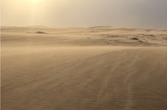
Winds blowing on the Arabian Peninsula


砂丘を作り出す砂は、風によって運ばれる程、十分に軽く、空気中に留まるには重すぎるサイズの砂粒です。物理的科学的にそれ以上小さなサイズに壊れ難い石英がその大部分を占めています。
Sand that creates dunes is sand grains that are light enough to be carried by wind and too heavy to stay in air. Quartz, which is physically and scientifically smaller and hard to break, accounts for majority.
跳動と表面クリープ
砂粒は跳動と表面クリープによって風の力で動かされています。主な砂の動きは、跳動で、風が砂の堆積の上を吹くに連れ、地表面から砂粒を摘み上げて前進する推力を与えます。
砂粒は自重で直ぐに地表面に戻りますが、弾んで再び空中に戻るか、衝撃で第二の砂粒を空中に放出させ、風下に吹き流させます。
この様にして跳動は、砂丘地帯を構成する砂の75%を移動させています。
跳動砂粒が地表面の重たい粒にぶつかると、空中に叩き出す程十分なエネルギーを持ちませんが、重たい粒が地表面に沿って僅かに前進する推力を与え、表面クリープを起こさせます。
表面クリープによっても砂丘地帯を構成する砂の25%以上が移動させられています。十分に持続性のある風があれば、跳動と表面クリープによって大量の砂を数百キロも数千キロも運ぶことができます。
砂の吹き流される方向に沿って風のエネルギーが十分に減じられる、砂粒は堆積します。地表面に不均等が起きて小さな窪みが作られると、長い時間を掛けてやがて砂丘に成長します。
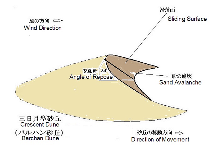
砂丘とは、一般的に明確な滑落面を持つ砂の堆積した盛土とされます。
砂域では風下に向かって粒の移動が遅いほど、砂の堆積は、増して砂は風下の端で盛り上がり始めます。
砂の土盛りが成長するとともに風上面に比べて風下面を険しくする様に、風下面の砂の堆積の最も多い個所が頂上により近く移動します。
険しくなり、成長した砂丘は風を風下面に下るよりも砂丘の頂上に向かわせます。
跳動する砂は稜線で落ち、そしてそれが落ち着く角度(安息角)(乾いた砂では32~34度)に到達するまで風下面をさらに険しくして行き、安息角に到達すると重力が砂を稜線から孤立させてゆっくり流れる雪崩、又は砂を大きな塊で落とし、風下斜面に引き下ろします。
跳動や表面クリープによるのではなく、滑りによる砂の移動は、滑落面と云う名の前進する砂丘の風下面を作り出しています。
砂丘の前進する度合いは、砂丘の稜線を越えて移動する砂の量および滑落面の高さに反比例しています。
例えば砂丘の高さが増すと前進する速度は緩まります。この様に砂丘は基本的に砂が風に押されて風向と直角に円弧を風上とした三日月型を作り出して形成されます。
Saltation (in geology) and surface creep
Sand grains are driven by wind force with saltation (in geology) and surface creep.
Main sand movement is saltation, which picks sand grains from ground surface and gives them a forward momentum as wind blows over a sand deposit.
Sand grains return to ground surface immediately by their own weight, but either bounce back into air or impact a second grain to give power to jump out into air to be blown downwind (splashing). In this way, saltation moves 75% of sand that makes up dunes.
When saltation sand grains hit a heavy grain on ground surface, they don’t have enough energy to knock them into air, but they give forward momentum that moves slightly along ground surface, causing surface creep.
Surface creep moves more than 25% of sand grains that make up dunes. With sufficiently persistent wind, saltation and surface creep can carry large amounts of sand to hundreds or thousands of kilometers.
When wind energy is sufficiently reduced to wind speeds lower than fluid threshold along direction in which sand is blown, sand grains begin to accumulate.
When unevenness occurs on ground surface and a small depression or gentle dip is created, it will eventually grow into dunes over a long period of time.
Sliding surface
Dune is generally referred to as sandy embankment with a well-defined slip-face. In sand areas, the slower grains move downwind, the more sand deposit increases and begins to grow in heigh at leeward edge.
As sand pile grows and downwind surface becomes steeper than upwind surface, the part with most sand deposit on downwind surface moves closer to crest. Steeped and grown dunes direct wind to crest rather than downwind surface.
Saltation sand falls on ridge, and downwind surface becomes even steeper until it reaches angle of repose (32-34 ° in dry sand), at which point gravity isolates sand from ridge. Slump with a slow-flowing avalanche or large chunks of sand and pull down on leeward slope.
Movement of sand by sliding, rather than by saltation or surface creep, creates downwind surface of an advancing dune called sliding surface.
Degree to which dune advances is inversely proportional to amount of sand that moves across dune ridge and height of sliding surface.
For example, as dune height increases, speed of advancement slows down. In this way, sand dunes are basically formed by creating a crescent shape with an arc upwind at right angles to wind direction when sand is pushed by wind.
砂丘の分類
風向きの変化によって、相互の重なり方が変わってくるので、砂丘は、横砂丘、縦砂丘および星形砂丘の3種類にほぼ分類できますが、その他にもドーム型砂丘や放物線砂丘等があります。
Classification of dunes
Dunes are roughly classified into three types, barchanoid type dune, longitudinal dune and star dune, by way of overlapping, depended on changing wind direction. In addition, there are also dome dune, parabolic dune, etc.
横砂丘
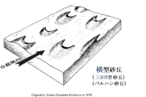
単一の滑落面を持つ殆どの砂丘は横砂丘と分類されます。横砂丘は、一般的にはバルハン砂丘とも呼ばれています。
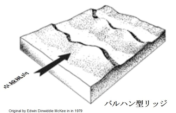
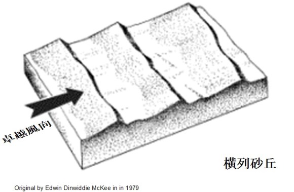
横砂丘は、砂丘を構成する砂の量によって徐々に移り替わる3つのサブタイプ(バルハン砂丘、バルハン型リッジと横列砂丘)から構成されます。
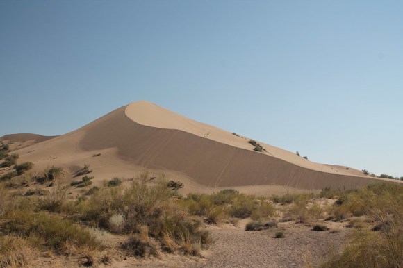
バルハン砂丘は、卓越風向と直角に三日月型を作り出して移動しやすく、徘徊する砂丘とも呼ばれています。
クウェイト南のからアブカイクを通り、ルブア・ハーリー沙漠まで広がっているジャーフーラ沙漠は、バルハン砂丘で被われています。
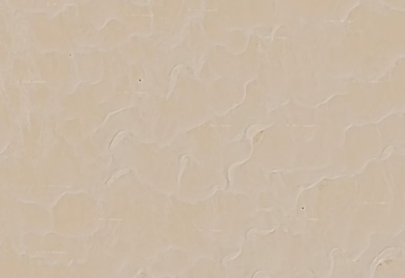
この沙漠の砂は石英分が90%以下と少なく、アラビア半島にある他の沙漠の様に砂が酸化鉄で被覆されてなく、その結果として砂の色が明るい赤では無く、青みがかった白です。
Barchanoid type dune
Most dunes with a single slip-face are classified as barchanoid type dune.
Barchanoid type dune consists of three subtypes (barchan dune, barchanoid ridge and transverse dune) that gradually change depending on amount of sand that makes up dunes.
A barchan dune creates a crescent shape at right angles to prevailing wind direction and is easy to move. Thus, it is also called a wandering dune.
The Jafurah desert is a typical place for barchan dunes. The Jafurah desert extends from southern Kuwait through Abqaiq to the Rub ‘al Khali and is covered by many of barchan dunes.
Sand in this desert has a low quartz content of 90% or less. Unlike the other deserts in the Arabian Peninsula, a sand grain is not covered with iron oxide, resulting in a bluish white rather than bright red sand.
原図はいずれも「E.D.McKee ed.,1979:A Study of Global Sand Seas, US Geological Survey Professional Paper1052」です。
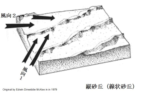
縦砂丘
2方向の風によって形成される砂丘は2つの滑落面を広げ、内陸性砂丘ではもっとも一般的で、連続して縦砂丘を生み出します。
線形砂丘またはセイフ砂丘とも呼ばれる縦砂丘eは、「風向が変わる事で横列砂丘が変化して形成される」と考えられています。卓越風向が多少異なる二方向から交互に吹いてくると横列砂丘を変形させ、様々な形の低い砂丘から中位の高さの砂丘が連なる縦砂丘を作り出します。
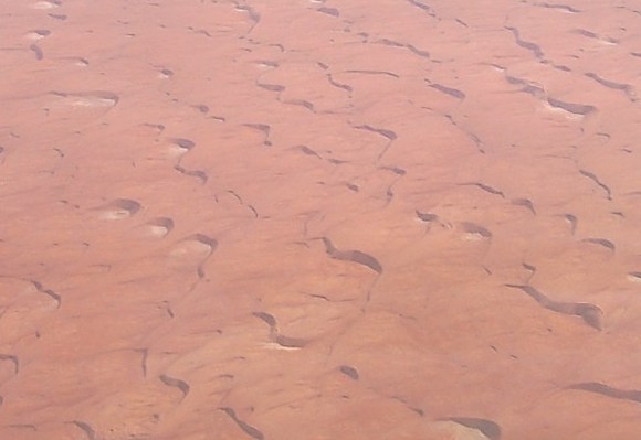
ナフード沙漠では数キロから十数キロ幅の谷で分けられている高さ90m程の数十キロの長さの縦砂丘が累々と重なり連なっています。
ナフード沙漠の際だった特徴は、縦砂丘を形成する一つ一つの砂丘のファルジと呼ばれる凹地の形にあります。ファルジは、ほぼ半楕円で、馬の蹄の巨大な跡の様な形をしています。
縦砂丘では砂は移動しても地形は殆ど変わらず、比較的安定していて、その凹地は、しばしば、植生ディカーカとも呼ばれ、灌木や草で砂を厚く被い、それらの根が砂を掴んだハンモック状となる植生のある砂沙漠を作り出しています。この為、縦砂丘地帯はディカーカと呼ばれる代表的な場所となっています。


Longitudinal dune
Dunes formed by two-way winds widen two sliding surfaces, producing continuous longitudinal dunes. This is the most common in inland dunes.
Longitudinal dune, also known as linear dune or seif dune, is thought to be “formed by variating barchanoid ridge and / or transverse dune as wind direction changes.” Alternating blows from two directions with slightly different predominant winds transform transverse dune, creating a series of low to medium-height dunes of various shapes.
In the An Nafud desert, longitudinal dunes with a height of about 90 m and a length of several tens of kilometers, which are divided by valleys with a width of several kilometers to a dozen kilometers, are are lined up one after another.
A distinctive feature of the An Nafud desert is shape of depressions called Falj in each of dunes that form longitudinal dune. Falj is almost semi-elliptical and shaped like a giant trace of a horse’s hoof.
In longitudinal dunes, terrain remains relatively stable as sand grains move, and its depressions, often referred to as dikakah, are thickly covered with vegetation such as shrubs and grass-bushes, and their roots. They are grabbing sand to create a sand mound looking like a hammock. For this reason, longitudinal dunes are a typical place called dikakah.
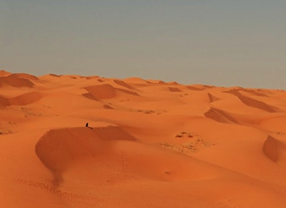
星形砂丘
星形砂丘は一般的にそれぞれが異なった方向に滑落面を持つ3つ以上の放射した腕を持ち、中央に頂上を形成します。砂を運ぶ風が長い間に変化して数方向から吹くとその時々で形成されたバルハン砂丘が互いに重なり合い、時として基盤から300m以上にも聳え立つこともあります。ルブア・ハーリー沙漠南東部やナフード沙漠南東部には星形砂丘と呼ばれる砂山が良く見受けられます。小さいけれども星形砂丘star duneとは呼ばれ良く知られている砂山がリヤード北のイルク・バンバーンの真ん中にもあります。
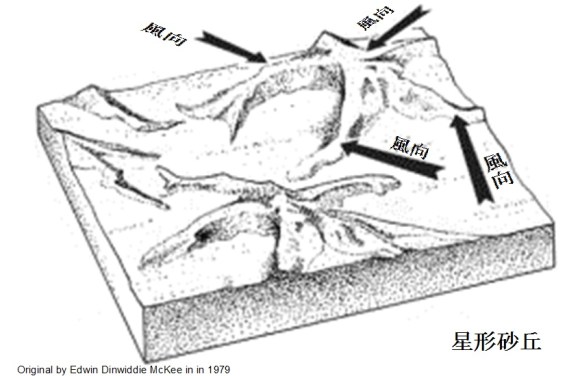
Star dune
Star dune generally has three or more radiating arms, each with a sliding surface in different directions, forming a central summit. When wind carrying sand changes over a long period of time and blows from several directions, barchan dunes formed from time to time overlaps with each other, and sometimes piled ups to more than 300 m from base. Sand dunes called star dunes are common in the southeastern Rub ‘al Khali and the southeastern An Nafud desert. There is also a small but a well-known sand dune called a star dune in middle of the Irq Banban north of Riyadh.
ドーム型砂丘
稀に外部滑落面の無いドーム型砂丘も形成される事がありますが、その起源は明確ではありません。形は、一般的に楕円錐台か円錐台をしています。一方向に傾斜している内部のすべり面を明らかなばあいは、星型砂丘またはバルハン砂丘から進化した可能性もあります。ルブア・ハーリー沙漠中央部南縁のラムラト・ウム・ガリブとラムラト・ハザールの様に、砂海の縁部で見られることもありますが、アラビア半島中央部では、基盤岩と堆積岩の露頭の間にドーム型砂丘が見られます。この様な例としては、リヤード西南西70kmにあるムザーヒミーヤ近傍が挙げられます。
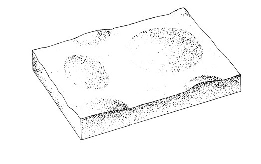
Dome dune
In rare cases, a dome dune without an external slip face may be formed, but its origin is not clear. Shape is generally oval mound or circular mound. It may have evolved from star dune or barchan dune if it reveals an internal slip surface that is sloping in one direction. It can be seen on sandy sea edge, such as the Ramlat Umm Gharib and the Ramlat Hazar on southern boundary of the central Rub ‘al Khali. As to the central Arabian Peninsula, dome dunes can be seen between outcrops of sedimentary rock and terrain of base rock, such as near Muzahimiyah, 70 km west-southwest of Riyadh.
放物線砂丘
放物線砂丘もバルハン砂丘同様に単一すべり面を持ちますが、2つの腕の端がそれぞれ風上に向けられ、バルハン砂丘とは反対の三日月形を作り出します。植生が動きの少ない側面に群生を形成し始めると、砂丘を安定させる効果があります。その効果が、砂丘の腕の端に沿った動きを遅らせるか、完全に停止させまが、砂丘の前縁は、腕の前に押し出され続け、典型的な逆三日月形を作り出します。こうして放物線状の砂丘が形成されます。最終的に、砂丘の鼻は植生によっても安定するか、または進行を続けて、腕から離れ、さらに先に進み、2筋の線形尾根を後ろに残します。
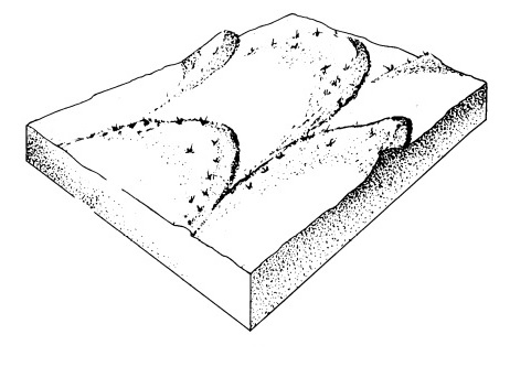
Parabolic dune
Parabolic dune has a single slip-face like a barchan dune, but 2 horns are directed upwind, creating a crescentic form in opposite direction in contrast of a barchan dune. When vegetation begins to form colonies on less moving sides, it has effect of stabilizing dune. This effect is to retard or stop movement along edges of dune arms, but leading edge of dune is pushed forward by wind to move ahead of arm, creating a typical reverse-crescent shape. In this way, a parabolic dune is formed. Eventually, nose of dune will either be controlled by vegetation or continue to progress, leaving arms to form two vegetated linear ridges.
