
The Rub’ al Khali desert, terrain & sediments


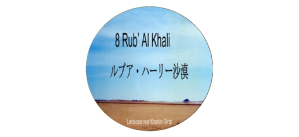
ルブア・ハーリー沙漠の地形
The Rub’ al Khali desert terrain
今日眺められる砂丘地帯は最近の極端に乾燥した数世紀の間に風に吹かれて移動した砂に表面を覆われていますが、第四期更新世の160万年前から10万年前に起きた数度の乾燥した時代に形成された沙漠を代表しています。
第三期鮮新世(500万年前から160万年前)後期および第四期更新世前期の湿った時代に水の流れで堆積層が作られました。しかし、更新世の間に湿った気候と乾燥した気候の交代があり、更新世の氷期最盛期に続く時期にはおそらく風成過程が活発でした。
最初の低い砂丘と砂シートは、70万年前、そして56万年から32.5万年以上前の湿潤期の前の更新世中期に形成された可能性があります。 この初期の段階では、ルブア・ハーリー沙漠はなく、更新世後期以降、特に完新世に来るより乾燥した条件の前兆に過ぎませんでした。
ルブア・ハーリー沙漠の地形は13から15位に分類できるといわれています。そのうちの代表的なものが砂丘の他に、炭酸塩の露頭などの岩盤、砂利平野、砂床とサブハがあります。砂丘環境である砂丘地帯の中も砂丘に加えて、砂床や砂丘間スペースに分けられ、砂丘間スペースが砂丘よりも広い砂丘間領域を占めています。
この堆積層が乾燥して、この砂丘地帯が形成され、ルブア・ハーリー沙漠の殆どを覆う土壌は砂丘地帯になりました。現在の高い尾根の縦方向の砂丘があるルブア・ハーリー沙漠の砂の堆積は、約6,000年前に始まったと考えられています。
西部地域ではインド洋から吹いてくる卓越風が数百キロも延びるゆるやかに起伏する砂の尾根(私は砂丘列と呼ぶ)を作り出しました。尾根の間に平行に並ぶ回廊では比較的容易に通行できます。中央地域では砂丘地帯の形はもっと複雑で予測し難いですが、最も劇的な眺望が見られるのは東部地域で。300メートルの高さの巨大なバルハン砂丘や折り重なった赤い横砂丘から成るウルークが太古の海底であった平らな白い含塩平地からそびえ立っています。
Dunes seen today are covered with aeolian sand that has been moved by winds of extremely dry climats in recent centuries, but their foundations were formed in the Pleistocene epoch. The Pleistocene epoch was a geological epoch in 1.6 million to 100,000 years ago, during which several dry climates had occurred already .
Sedimentary layers were formed by water streams during moist times of the late Pliocene in 5 to 1.6 million years ago and also the early Pleistocene. However, there were cycles between wet and dry climates during the Pleistocene, and geologival-age following the peak of Pleistocene’s Ice age was probably active in aeolian process.
Rudimentary low dunes and sand sheets may have formed 700,000 years ago, and in the mid-Pleistocene, before wet period in 560,000 to more than 325,000 years ago. In these early stages, the Rub’ al Khali was not existed and was only a precursor to more drier conditions that came after the late Pleistocene, especially the Holocene epoch.
The terrain of the Rub’ al Khali is classified into 13 to 15. In addition to sand dunes, typical of these are bedrocks (carbonate outcrops, etc.), gravel plains, sand sheet and sabkhas (salt flats). A dune environment can be further divided into dunes, sand sheet, interdunes and sabkhas. Spaces other than dunes occupy larger areas than that of dunes themselves.
Sand that covers most of the Rub’ al Khali was made by drying sedimentary layers. Sand deposits of the Rub’ al Khali, with its current high ridge longitudinal dunes, began about 6,000 years ago.
In the Western Rub’ al Khali region, prevailing winds from the Indian Ocean have created gently undulating sand ridges (dune rows) that extend for hundreds of kilometers. Parallel corridors between ridges are relatively easy to get through. Dune shapes are more complex and unpredictable in the Central Rub’ al Khali area, but the most dramatic views are in the Eastern Rub’ al Khali area. A uruq consisting of a huge barchan dunes with a height of 300 m and a folded red barchanoid type dunes rises from white flat sabkhas (white salt flats) that were ancient sea beds.
ルブア・ハーリー沙漠の砂丘を構成する堆積物
Sediments that make up the dunes of the Rub’ al Khali
ルブア・ハーリー沙漠内および周囲の露頭のほとんどすべてが炭酸塩であるのに、ルブア・ハーリー沙漠の大部分では、堆積物は主に珪質であり、その最大90%が石英で、残りは主に長石です。 但し、ルブア・ハーリー沙漠東部では、単結晶石英が約71〜76%、長石が14〜16%を占め、残りが炭酸塩、チャート、および変成粒子で構成されています。
堆積物は淡黄色から赤みがかった黄色で、石英粒子の表面に酸化鉄が薄くコーティングされているため、東部でも赤く見えます。 アラビア湾から約100キロ以内のルブア・ハーリー沙漠の北部と東部の砂丘は、おおむね石灰質で、炭酸塩はドロマイトまたは方解石のいずれかにしても二次的な量のままです。沙漠の最北東部でさえ、堆積物はまだ珪岩であり、不思議なことに深い赤の色合いがあります。
もともと先カンブリア時代の主なアラビア楯状地の結晶質の岩石から大量の砂が侵食されました。 侵食された砂の多くは、新第三紀のハドルク層とホフーフ層、カンブリア紀-オルドビス紀のサクとワジッドの層など、広範囲にわたる砕屑層に組み込まれています。 これらの地層が風化して侵食されたため、大量の緩い砂が解放されました。
中新世と鮮新世の時代に、隆起したアラビア楯状地からの排水が内部ホモクラインの中生代の断崖を突き破り、大量の石英質の砕屑性堆積物を堆積させ、現在は中新世のハドルク層と鮮新世のホフーフ層を形成しています。 未分化の上部第三紀の砂と泥灰土として、 これらの砂質の新第三紀層は、後にルブア・ハーリー沙漠の砂丘にある大量の砂の供給源になりました。
中新世と鮮新世の間に多湿で湿潤な気候が優勢で、鮮新生初期の第四紀に、非常に大きな扇状地が形成されました。そして、サラワート山脈の分水嶺に広範囲にわたる集水域のある涸れ谷ビーシャおよび涸れ谷タスリースを支流に持つ涸れ谷ダワースィルに代表され、さらに涸れ谷サフバー、涸れ谷ナジュラーン、涸れ谷ハブーナなどの主要な河川、またはワーディー(涸れ谷)がルブア・ハーリー沙漠に礫岩と砂の堆積物を流し込みました。この堆積物が、現在のルブア・ハーリー沙漠の赤い砂の源となっています。
降水量が多い時期には、ザグロス山脈やイラン高原の他の高地(がひどく侵食され、堆積物がチグリス川、カラン川、その他の川によってアラビア湾に運ばれました。 特に北と北東のルブア・ハーリー沙漠の砂丘は、陸地化し、乾燥した時期のアラビア湾から堆積物が今日よりも強い風によって運ばれてきました。
ザグロス山脈のさまざまな地層は、その範囲がルブア・ハーリー沙漠の堆積物の主な発生源であることがほぼ確認されています。イラン南部全体に広く露出しているアガジャリ層(は、主に石英砂岩で構成されています。 同様に、バフティヤーリーコングロマリットは石英砂の厚いマトリックスを持っていますが、炭酸塩がザグロス山脈では一般的です。
アラブ首長国連邦のほとんどの北部の砂丘の炭酸塩物質は、ザグロス山脈から派生し、シャマール風によってルブア・ハーリー沙漠地域に運ばれました。この砂は、アラビア湾岸に沿ったジャーフーラ沙漠や白い海岸砂丘を形成すると共に、ルブア・ハーリー沙漠の堆積物増量に寄与しています。
第3のルブア・ハーリー沙漠への堆積物供給としては、オマーンのハジャル山脈があります。この山脈の高い山々から南東に流れる多くの急なワーディーが東部と北東部に大量の沖積層と砂利を供給しており、この豊富な供給源が原因となって、高い三日月形の砂丘の大きな砂山のあるウルーク・ムウタリダとガニーム・サンドが生まれています。
In most of the Rub’ al Khali, sediments are predominantly siliceous, up to 90% quartz, and rest predominantly feldspar, while almost all outcrops in and around Rub’ al Khali are carbonate. In the eastern Rub’ al Khali, monocrystalline quartz accounts for 71-76%, feldspar accounts for 14-16%, and rest consists of carbonate, chert, and metamorphic grains.
Color of deposits is light yellow to reddish yellow, and surfaces of quartz particles are light coated with ferric oxide, therefore they look red even in the eastern Rub’ al Khali. Within distance of about 100 kilometers from the Arabian Gulf, dunes in the northern and eastern Rub’ al Khali are largely calcareous, with carbonates remaining secondary to either dolomite or calcite. Even in the northeastern Rub’ al Khali, sediments are still quartzite and strangely have a deep red tint.
Originally, large amounts of sand were eroded from crystalline rocks of the main Precambrian Arabian shields. Much of the eroded sand is incorporated into a wide range of debris layers, including the Hadrukh formation and the Hofuf formation of the Neogene and the Saq formation and the Wajid formation of the Cambro-Ordovician. A large amount of loose sand was released as these formations were weathered and eroded.
During the Miocene and Pliocene eras, drainage from the uplifted Arabian shield broke through the Mesozoic cliffs of the interior homocline, depositing large amounts of quartz detrital deposits and is now the Miocene Hadrukh formation. And the Pliocene Hofuf formation. As undifferentiated Upper Tertiary sand and marl, these sandy Neogene layers later became a source of large amounts of sand in the Rub’ al Khali.
A humid and humid climate predominates between the Miocene and the Pliocene, forming a very large alluvial fan in the early Quaternary of Pliocene. It is represented by the Wadi al Dawasir, which has the Wadi Bisha and the Wadi Tathlith as its tributaries, which have extensive catchment areas in the diversion ridges of Sarawat mountains, and also major rivers and or wadis such as the Wadi as-Sahba, the Wadi Najran, and the Wadi Habunah. Pour gravel and sand deposits into the Rub’ al Khali. This deposit is source of red sand of the today’s Rub’ al Khali.
During high rainfall, the Zagros mountains and other highlands of the Iranian plateau were severely eroded, and sediments were carried to the Arabian Gulf by the Tigris river, the Karun river and other rivers. Especially to dunes in the northern northeastern Rub’ al Khali, sediments were carried by stronger winds than today from the Arabian Gulf during that had been a dry land and a dry time.
Various formations of the Zagros mountains have been largely confirmed to be another important source of the Rub’ al Khali sediments. The Agha Jari formation, which is widely exposed throughout the southern Iran, is mainly composed of quartz sandstone. Similarly, the Bakhtiari conglomerate has a thick matrix of quartz sand, but carbonates are common in the Zagros Mountains.
Carbonate sediments of dunes in the northern United Arab Emirates are derived from the Zagros mountains and then they have been transported by shamal winds to the Rub’ al Khali desert. Those sediments also form the Jafurah Desert and white coastal dunes along the Arabian Gulf, however they finally contribute to sedimentation growth of the Rub’ al Khali.
A third source of sediment to the Rub’ al Khali is the Hajar mountains in Oman. Many steep wadis flowing southeast from this high mountain range supply large amounts of alluvium and gravel to the eastern and northeastern Rub’ al Khali, and this abundant source caused such large high crescent dunes as the Uruq Al Mutaridah and the Ghanim Sands.
